Carolina Beach in New Hanover County, North Carolina — The American South (South Atlantic)
To close the port of Wilmington...
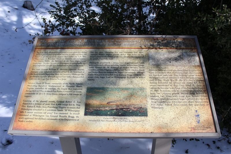
Photographed by Evan Dwyer, January 24, 2025
1. "To close the port of Wilmington is undoubtedly the most important and effective demonstration..." Marker
"To close the port of Wilmington is undoubtedly the most important and effective demonstration that can be made." U.S. Navy Department Secretary Gideon Welles
The U.S. Navy Department proposed several plans for closing Wilmington Harbor to blockade running in 1862 and 1863, but failed to get the necessary support from either the U.S. War Department or President Abraham Lincoln's administration. Yet Gideon Welles, the Secretary of the Navy Department exclaimed: "To close the port of Wilmington is undoubtedly the most important and effective demonstration that can be made."
Not until General William T. Sherman captured Atlanta, Georgia, a key industrial and railroad hub in the heartland of the South in early September 1864, did Secretary Welles get the go-ahead to organize an attack against Fort Fisher that guarded entry into the Cape Fear River at New Inlet.
Admiral David D. Porter, commander of the North Atlantic Blockading Squadron headquartered at Hampton Roads, Virginia, assembled 64 warships, the largest fleet organized during the Civil War, to attack Fort Fisher. General U.S. Grant, commander of all U.S.
this page online
Learning of the planned assault, General Robert E. Lee dispatched a division of more than 6,400 troops led by Maj. Gen. Robert F. Hoke, from Petersburg, Virginia to ensure that Wilmington remained in Confederate hands. "If Wilmington falls I cannot maintain my army," Lee cautioned. In overall command at Wilmington was General Braxton Bragg, the newly appointed, but disliked, commander of the Department of North Carolina.
For two days, Christmas Eve and Christmas Day 1864, Admiral Porter's mighty armada shelled Fort Fisher in the largest naval bombardment of the war. Despite the intensity of the attack, Fort Fisher held.
During the grand battle, a diverse force of approximately 3,400 gray-uniformed soldiers, including North Carolina State Troops under General W.W. Kirkland of Hoke's Division, South Carolina cavalry, Virginia artillery, and North Carolina Junior and Senior Reserves manned the Sugar Loaf defenses. After the Union fleet and army sailed away, General Bragg withdrew the troops from Sugar Loaf to Wilmington. It would be a fatal mistake.
Although Union naval and army forces failed to capture Fort Fisher at Christmas 1864, they returned for a second attempt less than three weeks later. Their campaign turned out to be the largest combined operation in American military history until D-Day, World War II. The U.S. Navy's pinpoint shelling dismantled the defenses and enabled U.S. Army troops, commanded by Brig. Gen. Alfred H. Terry, to capture the fort after heavy hand-to-hand combat on January 15, 1865. In keeping with his controversial reputation for being "not a fighting general," Braxton Bragg declined to reinforce Fort Fisher with troops from General Hoke's Division, which did not reach Sugar Loaf until after the U.S. Army's expeditionary forces had come ashore. After securing Fort Fisher, Federal forces turned their gun sights on Wilmington.
Erected 2021 by Sons of Union Veterans of the Civil War Charitable Foundation, Town of Carolina Beach.
Topics. This historical marker is listed in these topic lists: Forts and Castles • War, US Civil • Waterways & Vessels. A significant historical date for this entry is January 15, 1865.
Location. 34° 2.733′ N, 77° 53.831′ W. Marker is in Carolina Beach, North Carolina, in New Hanover County. It can be reached from North Lake Park Boulevard 0.2 miles north of Bennet Lane, on the right when traveling north. Located in Joseph Ryder Lewis Jr. Civil War Park north of the Publix Super Market Commons at Federal Point. Touch for map. Marker is at or near this postal address: 1018 N Lake Park Blvd, Carolina Beach NC 28428, United States of America. Touch for directions.

Regionally, this marker is in the Coastal Plain and on the Cape Fear Coast. It is also in the American South, specifically in the Upper South, in the Tidewater, and on the Eastern Seaboard. Globally, it is in the North Atlantic Region, North America, the Western Hemisphere, the Western World, and the Anglosphere. Historically, it finds itself in what was once the territory of the Mississippian Culture, one of the original Thirteen Colonies, one of the Confederate States of America, and the Antebellum South.
Other nearby markers. At least 8 other markers are within walking distance of this marker: We are strongly entrenched here... (a few steps from this marker); Such parts of the Sugar Loaf line... (a few steps from this marker); I hope we can hold Wilmington (within shouting distance of this marker); For a little while it was a lively and interesting fight (within shouting distance of this marker); Joseph Ryder Lewis Jr. Civil War Park (about 300 feet away, measured in a direct line); Battlefield of Sugar Loaf (about 300 feet away); Sugar Loaf Line (about 600 feet away); Civil War Fortifications (approx. 0.3 miles away). Touch for a list and map of all markers in Carolina Beach.
Credits. This page was last revised on June 16, 2025. It was originally submitted on June 15, 2025, by Evan Dwyer of Richmond, Virginia. This page has been viewed 135 times since then and 20 times this year. Photo 1. submitted on June 15, 2025, by Evan Dwyer of Richmond, Virginia. • Bernard Fisher was the editor who published this page.
