Near Smithfield in Isle of Wight County, Virginia — The American South (Mid-Atlantic)
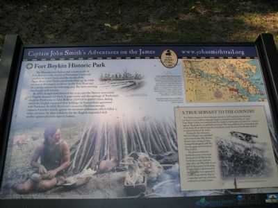
Fort Boykin Historic Park
Captain John Smith’s Adventures on the James
— www.johnsmithtrail.org —
By 1609, drought had withered the crops, and the Natives were weary of English demands for food. A peace treaty and the marriage of Powhatan’s daughter Pocahontas to John Rolfe in 1614 led to quieter times, during which the English expanded their holdings far beyond their agreement with Powhatan. In 1622, Powhatan’s successor, Opechancanough, organized punitive attacks against the incursive settlements, which killed many colonists. He then withdrew, but the English responded with warfare against all of the region’s Indians.
A True Servant to the Country.
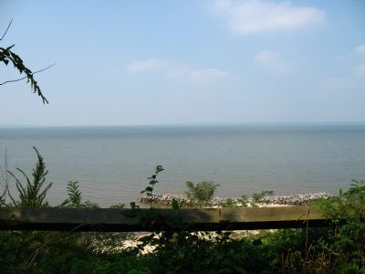
Fort Boykin began its role in American history in 1623 and since then has been involved in every military campaign fought on American soil. On May 11, 1623, Capt. Roger Smyth was commissioned to construct a fortification to protect the colonists against “Spaniards by sea and Indians by land.” The steep cliff here, its commanding view of the James River and its naturally deep ditches made the site of Fort Boykin ideal. It was then christened The Castle.
During the Revolutionary War, Fort Boykin was refortified and renamed after Maj. Francis Boykin, then serving on Gen. George Washington’s staff. The fort was again used during the War of 1812.
The present earthwork fortification was constructed during the Civil War by the Confederate army between June 1861 and May 1862. It was part of the system for blocking access to Richmond by river. The fort was captured by Union troops shortly after its completion and since then has remained essentially intact.
(captions)
“The New World” © MMV, New Line Productions, Inc. All rights reserved. Photo by Merie Wallace. Photo appears courtesy of New Line Productions, Inc.
Drawing by Marc Castelli for the John Smith Four Hundred Project © 2006
Capt. John Smith’s Trail
John Smith knew the James River by its Algonquian name: Powhatan, the same as the region’s paramount chief. Smith traveled the river many times between 1607 and 1609, trading with Virginia Indians to ensure survival at Jamestown. What he saw of Virginia’s verdant woodlands and pristine waters inspired him to explore the greater Chesapeake Bay, chronicling its natural wonders.
Capt. John Smith’s Trail on the James is a 40-site water trail and auto tour for modern explorers.
Erected by Captain John Smith’s Trail, James River Association, Virginia Department of Conservation and Recreation, Chesapeake Bay Gateways Network. (Marker Number 35.)
Topics. This historical marker is listed in these topic lists: Colonial Era • Exploration • Forts and Castles • Settlements & Settlers • War of 1812 • War, US Civil • War, US Revolutionary. A significant historical date for this entry is May 11, 1623.
Location. This marker has been replaced by another marker nearby. It was located near 37° 2.027′ N, 76° 37.066′ W. Marker was near Smithfield, Virginia, in Isle of Wight County. Marker could be reached from the intersection of Fort Boykin Trail (Virginia Route 705) and Mogarts Beach Road (Virginia Route 673), on the left when traveling north. Touch for map. Marker was at or near this postal address: 7410 Fort Boykin Trail, Smithfield VA 23430, United States of America. Touch for directions.
Other nearby markers. At least 8 other markers are within walking distance of this location. Welcome to Fort Boykin Historic Park (here, next to this marker); Welcome to Fort Boykin (a few steps from this marker); Fort Boykin (a few steps from this marker); Fort Boykin Memorial (within shouting distance of this marker); Camp Eustis Attacks Fort Boykin (about 300 feet away, measured in a direct line);
The Well (about 300 feet away); The Fort's Last Private Owners (about 400 feet away); Fort Boykin during the Civil War (about 600 feet away). Touch for a list and map of all markers in Smithfield.
Related marker. Click here for another marker that is related to this marker. New Marker At This Location titled Welcome to Fort Boykin Historic Park.
Credits. This page was last revised on April 7, 2024. It was originally submitted on September 24, 2007, by Laura Troy of Burke, Virginia. This page has been viewed 2,625 times since then and 45 times this year. Photos: 1. submitted on September 24, 2007, by Laura Troy of Burke, Virginia. 2. submitted on May 4, 2009, by Bernard Fisher of Richmond, Virginia. 3. submitted on September 24, 2007, by Laura Troy of Burke, Virginia. • J. J. Prats was the editor who published this page.


