Charleston on Staten Island in Richmond County, New York — The American Northeast (Mid-Atlantic)
A Forest Reborn
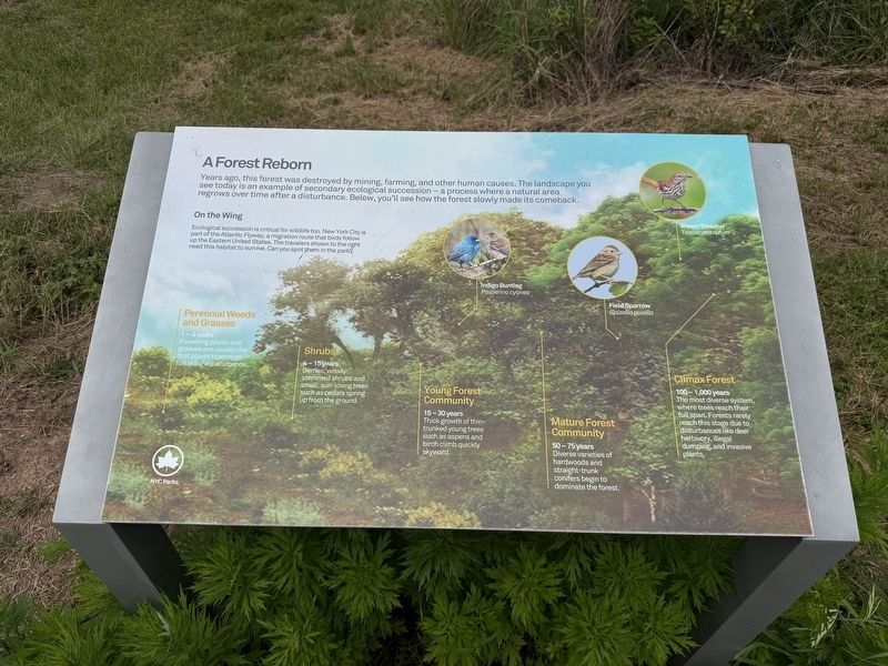
Years ago, this forest was destroyed by mining, farming, and other human causes. The landscape you see today is an example of secondary ecological succession — a process where a natural area regrows over time after a disturbance. Below, you'll see how the forest slowly made its comeback.
On the Wing
Ecological succession is critical for wildlife too. New York City is part of the Atlantic Flyway, a migration route that birds follow up the Eastern United States. The travelers shown to the right need this habitat to survive. Can you spot them in the park?
Indigo Bunting Passeirina cyanea • Field Sparrow Spizella usilla • Brown Thrasher Toxostoma rufum
Perennial Weeds and Grasses
1 - 4 years
Flowering plants and grasses are usually the first plants to emerge following a disturbance.
Shrubs
4 - 15 years
Berries, woody-stemmed shrubs and small, sun-loving trees such as cedars spring up from the ground.
Young Forest Community
15 - 30 years
Thick growth of thin-trunked young trees such as aspens and birch climb quickly skyward.
Mature Forest Community
50 - 75 years
Diverse varieties of hardwoods
this page online
Climax Forest
100 - 1,000 years
The most diverse system, where trees reach their full pan. Forests rarely reach this stage due to disturbances like deer herbivory, illegal dumping, and invasive plants.
Erected by NYC Parks.
Topics and series. This historical marker is listed in these topic lists: Environment • Horticulture & Forestry • Parks & Recreational Areas. In addition, it is included in the NYC Parks series list.
Location. 40° 31.875′ N, 74° 13.834′ W. Marker is on Staten Island, New York, in Richmond County. It is in Charleston. It can be reached from Bricktown Way west of Tyrellan Avenue, on the right when traveling west. The marker stands on the grounds of Fairview Park. Touch for map. Marker is at or near this postal address: 165 Bricktown Way, Staten Island NY 10309, United States of America. Touch for directions.

Regionally, this marker is in New York City. It is also in the American Northeast, in the Mid-Atlantic, and on the Eastern Seaboard. Globally, it is in the North Atlantic Region,

Other nearby markers. At least 8 other markers are within 2 miles of this marker, measured as the crow flies: Fairview Park (approx. 0.2 miles away); Welcome to Kreischerville (approx. 0.2 miles away); Welcome to the Clay Pit Ponds Bird Conservation Area (approx. half a mile away); September 11, 2001 Memorial (approx. half a mile away); Charleston War Memorial (approx. 0.7 miles away); Pleasant Plains Memorial (approx. 0.9 miles away); Staten Island Civil War Memorial (approx. 1.1 miles away); Joseph W. Palmer (approx. 1.1 miles away). Touch for a list and map of all markers in Staten Island.
Additional commentary.
1. About the marker
While not every sign interpreting natural history serves as a historical marker for the purposes of the database, this one does. It shares how the history of human activity has affected this and other forests, particularly mining and farming.
— Submitted June 19, 2025, by Devry Becker Jones of Washington, District of Columbia.
Credits. This page was last revised on June 19, 2025. It was originally submitted on June 19, 2025, by Devry Becker Jones of Washington, District of Columbia. This page has been viewed 124 times since then and 25 times this year. Photos: 1, 2. submitted on June 19, 2025, by Devry Becker Jones of Washington, District of Columbia.
