Carolina Beach in New Hanover County, North Carolina — The American South (South Atlantic)
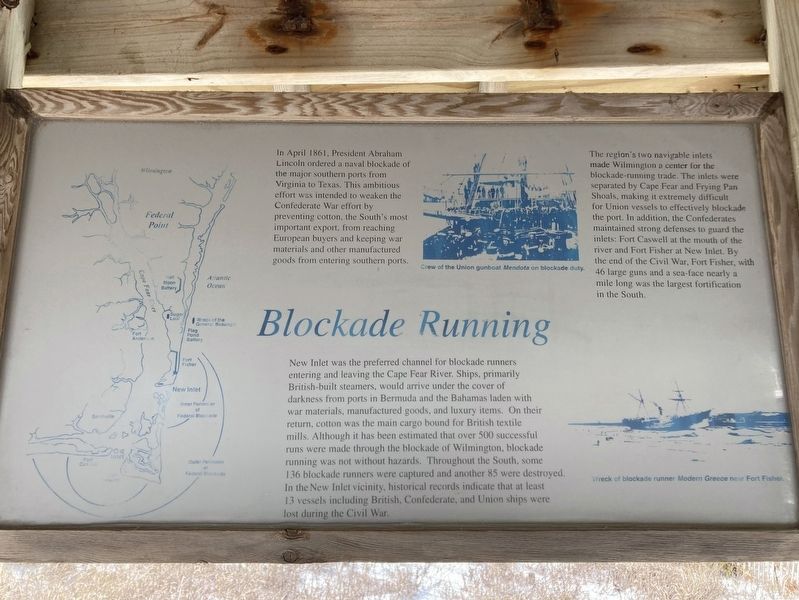
Blockade Running
Photographed by Evan Dwyer, January 24, 2025
1. Blockade Running Marker
The region's two navigable inlets made Wilmington a center for the blockade-running trade. The inlets were separated by Cape Fear and Frying Pan Shoals, making it extremely difficult for Union vessels to effectively blockade the port. In addition, the Confederates maintained strong defenses to guard the inlets: Fort Caswell at the mouth of the river and Fort Fisher at New Inlet. By the end of the Civil War, Fort Fisher, with 46 large guns and a sea-face nearly a mile long was the largest fortification in the South.
New Inlet was the preferred channel for blockade runners entering and leaving the Cape Fear River. Ships, primarily British-built steamers, would arrive under the cover of darkness from ports in Bermuda and the Bahamas laden with war materials, manufactured
this page online
(captions)
Crew of the Union gunboat Mendota on blockade duty.
Wreck of the blockade runner Modern Greece near Fort Fisher.
Topics. This historical marker is listed in these topic lists: Forts and Castles • Industry & Commerce • War, US Civil • Waterways & Vessels. A significant historical month for this entry is April 1861.
Location. 34° 1.626′ N, 77° 53.67′ W. Marker is in Carolina Beach, North Carolina, in New Hanover County. It can be reached from the intersection of Lake Drive and Carolina Beach Avenue South when traveling east. Touch for map. Marker is at or near this postal address: 701 Carolina Beach Ave S, Carolina Beach
Photographed by Evan Dwyer, January 25, 2025
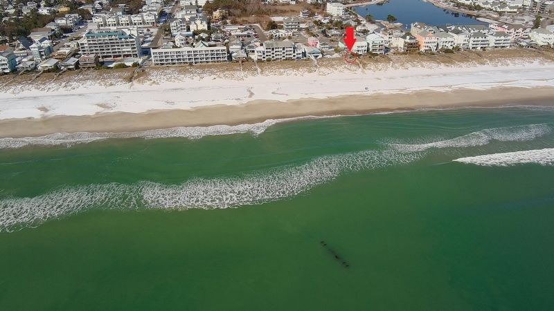
2. Marker Gazebo Proximity to the Wreck
The gazebo with the Blockade Running marker is circled in red beneath the red arrow. The remains of the blockade runner General Beauregard are just offshore - the prominent features are from her propulsion system, notably the axle for the sidewheels. This drone photo shows the location of the wreck compared to the gazebo and associated markers.

Regionally, this marker is in the Coastal Plain and on the Cape Fear Coast. It is also in the American South, specifically in the Upper South, in the Tidewater, and on the Eastern Seaboard. Globally, it is in the North Atlantic Region, North America, the Western Hemisphere, the Western World, and the Anglosphere. Historically, it finds itself in what was once the territory of the Mississippian Culture, one of the original Thirteen Colonies, one of the Confederate States of America, and the Antebellum South.
Other nearby markers. At least 8 other markers are within 2 miles of this marker, measured as the crow flies: The General Beauregard (here, next to this marker); Shipwreck Site (here, next to this marker); Loughlin Cottage (approx. half a mile away); The Joy Lee Apartment Building and Annex (approx. ¾ mile away); Battlefield of Sugar Loaf (approx. 1.2 miles away); Joseph Ryder Lewis Jr. Civil War Park (approx. 1.2 miles away); We are strongly entrenched here... (approx. 1.3 miles away); To close the port of Wilmington... (approx. 1.3 miles away). Touch for a list and map of all markers in Carolina Beach.
More about this marker. Marker is one of three mounted in a gazebo located along the Lake Public Beach Access boardwalk.
Regarding Blockade Running. A wrecked blockade runner, General Beauregard, is just offshore.
Related markers. Click here for a list of markers that are related to this marker. These two other markers combine with this one within the gazebo to add context to the shipwreck off shore.
Credits. This page was last revised on June 23, 2025. It was originally submitted on June 20, 2025, by Evan Dwyer of Richmond, Virginia. This page has been viewed 134 times since then and 22 times this year. Photos: 1, 2. submitted on June 20, 2025, by Evan Dwyer of Richmond, Virginia. • Bernard Fisher was the editor who published this page.
