Fort Story in Virginia Beach, Virginia — The American South (Mid-Atlantic)
Cape Henry Memorial Cross
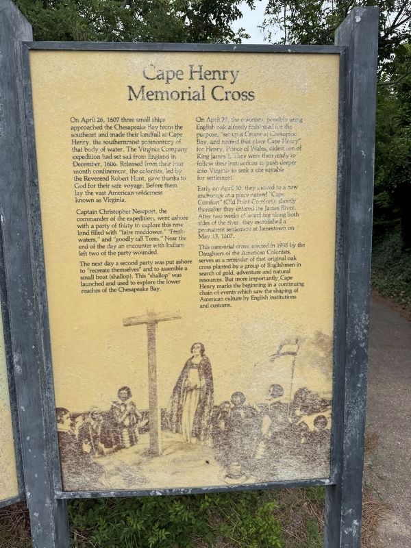
On April 26, 1607 three small ships approached the Chesapeake Bay from the southeast and made their landfall at Cape Henry, the southernmost promontory of that body of water. The Virginia Company expedition had set sail from England in December, 1606. Released from their four month confinement, the colonists, led by the Reverend Robert Hunt, gave thanks to God for their safe voyage. Before them lay the vast American wilderness known as Virginia.
Captain Christopher Newport, the commander of the expedition, went ashore with a party of thirty to explore this new land filled with "faire meadows," "Fresh-waters," and "goodly tall Trees." Near the end of the day an encounter with Indians left two of the party wounded.
The next day a second party was put ashore to "recreate themselves" and to assemble a small boat (shallop). This "shallop" was launched and used to explore the lower reaches of the Chesapeake Bay.
On April 29, the colonists, possibly using English oak already fashioned for the purpose, "set up a Crosse at Chesapioc Bay, and named that place Cape Henry" for Henry, Prince of Wales, oldest son of King James
this page online
Early on April 30, they moved to a new anchorage at a place named "Cape Comfort" (Old Point Comfort), shortly thereafter they entered the James River. After two weeks of searching along both sides of the river, they established a permanent settlement at Jamestown on May 13, 1607.
This memorial cross, erected in 1935 by the Daughters of the American Colonists, serves as a reminder of that original oak cross planted by a group of Englishmen in search of gold, adventure and natural resources. But more importantly, Cape Henry marks the beginning in a continuing chain of events which saw the shaping of American culture by English institutions and customs.
Erected by National Park Service, U.S. Department of the Interior.
Topics. This historical marker is listed in these topic lists: Colonial Era • Exploration • Settlements & Settlers • Waterways & Vessels. A significant historical date for this entry is April 26, 1607.
Location. 36° 55.667′ N, 76° 0.547′ W. Marker is in Virginia Beach, Virginia. It is in


Regionally, this marker is in Hampton Roads, specifically in Coastal Virginia, and in the Hampton Roads Metropolitan Area. It is also in the American South, specifically in the Upper South, in the Tidewater, and on the Eastern Seaboard. Globally, it is in the North Atlantic Region, North America, the Western Hemisphere, the Western World, and the Anglosphere. Historically, it finds itself in what was once the territory of the Mississippian Culture, one of the original Thirteen Colonies, one of the Confederate States of America, and the Antebellum South.
Other nearby markers. At least 8 other markers are within walking distance of this marker: Gateway to the Chesapeake Bay (here, next to this marker); Battle of the Capes 1781 (here, next to this marker); Cape Henry Memorial (within shouting distance of this marker); François Joseph Paul de Grasse (within shouting distance

Photographed by Sandra Hughes, August 9, 2010
3. Cape Henry Memorial Cross Marker
This is a photo of the three markers together before they weathered.
Credits. This page was last revised on June 21, 2025. It was originally submitted on June 21, 2025, by Richard E. Miller of Oxon Hill, Maryland. This page has been viewed 243 times since then and 59 times this year. Photos: 1, 2. submitted on June 21, 2025, by Devry Becker Jones of Washington, District of Columbia. 3. submitted on October 15, 2011, by Sandra Hughes Tidwell of Killen, Alabama, USA. • Devry Becker Jones was the editor who published this page.
