Fair Haven in New Haven in South Central Region, Connecticut — The American Northeast (New England)
How have people changed the marsh?
Peabody Museum of Natural History, Yale University
Photographed by Conrad Ward, April 26, 2024
1. How have people changed the marsh - Marker
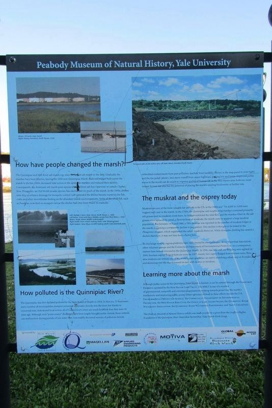
The Quinnipiac and Mill River salt marsh was once the largest salt marsh in the state. Gradually, the marshes have been filled in, leaving the 1000-acre Quinnipiac Marsh. Railroad bridges built across the marsh in the late 1800s decreased tidal action in the upstream marshes and reduced their salinity. Consequently, the dominant salt marsh grass species changed from salt hay (Spartina) to cattails (Typha). Now Phragmites, an Old World invader species, has encroached on much of the marsh. In the 1930s, ditches were dug to enhance drainage for mosquito control. Left untended the ditches became nurseries for fish, crabs and other invertebrates feeding on the abundant marsh microorganisms. Some of the small fish, such as Fundulus, now feed on mosquito larvae the ditches had once been meant to eradicate.
How polluted is the Quinnipiac River?
The Quinnipiac was first declared polluted by the State Board of Health in 1914. In that era, 71 businesses and a number of municipalities dumped untreated wastewater directly into the river, but thanks to concerted state, federal and local action, all of Connecticut's rivers are much healthier than they were 50 years ago. Although such "point source" discharges have been largely brought under control, these controls can malfunction during periods of low water flow. Less readily discerned sources of pollution include embedded contaminants from past pollution, leachate from landfills (Shown in the map panel to your right) and the tire pond (above), and storm runoff from major highways, parking lots and lawns. Improved public access to the marsh can do much to improve quality of human life in the New Haven area; however, more intense human use also has the potential of placing the marsh's existing biodiversity at further risk.
The muskrat and the osprey today
Muskrats
this page online
To encourage nesting, osprey-platforms have been erected by the Quinnipiac River Watershed Association, other volunteer groups and the Connecticut Department of Environmental Protection. As a consequence, ospreys have indeed returned to the Quinnipiac Marsh. In 1996, one nest and one fledgling were sighted; in 2000, fourteen osprey fledged from six nests; by 2003,
Photographed by Conrad Ward, April 26, 2024
2. How have people changed the marsh - Marker
Learning more about the marsh
Although public access to the Quinnipiac Tidal Marsh is limited, it can be entered through the Fargeorge Preserve operated by the New Haven Land Trust. The NHLT is one of a number of governmental, nonprofit and volunteer organizations working towards preserving the marsh's biodiversity and improving public access. Other agencies involved in these efforts include the U.S. Environmental Protection Agency, The Connecticut Department of Environmental Protection, The New Haven Bird Club, The Office Of Long Island Sound, The Quinnipiac River Watershed Association, The Quinnipiac River Watershed Partnership, and Trout Unlimited.
This Peabody Museum of Natural History exhibit was made possible by a grant from the Geoffrey Hughes Foundation to the Quinnipiac River Watershed Partnership, Tidal Marsh Work Group.
Erected by Peabody Museum of Natural History, Yale University.
Topics. This historical marker is listed in these topic lists: Animals • Environment • Waterways & Vessels.
Location. 41° 18.525′ N, 72° 53.344′ W. Marker is in New Haven in South Central Region, Connecticut. It is in Fair Haven. It is on Front Street south of East Grand Avenue, on the right when traveling north. Located in the Quinnipiac River Park. Touch for map. Marker is at or near this postal address: 156 Front St, New Haven CT 06513, United States of America. Touch for directions.

Regionally, this marker is in the Connecticut River Valley and on the Connecticut Shoreline. It is also in the American Northeast, in New England, and on the Eastern Seaboard. Globally, it is in the North Atlantic Region, North America, the Western Hemisphere, the Western World, and the Anglosphere. Historically, it finds itself in what was once New Haven County and also one of the original Thirteen Colonies.
Other nearby markers. At least 8 other markers are within 2 miles of this marker, measured as the crow flies: The Quinnipiac Marsh Timeline (a few steps from this marker); The Quinnipiac River (approx. 0.2 miles away); Grannis Island (approx. 0.7 miles away); Welcome to the Preserve (approx. 0.8 miles away); The Connecticut Twenty-Ninth Colored Regiment, C. V. Infantry (approx. 0.9 miles away); 32nd Ward World War I Memorial (approx. 1.1 miles away); Jocelyn Square (approx. 1.1 miles away); New Haven World War Two Veterans Memorial (approx. 1.1 miles away). Touch for a list and map of all markers in New Haven.
Also see . . .
1. Yale Peabody Museum. (Submitted on May 30, 2025, by Michael Herrick of Southbury, Connecticut.)
2. Peabody Museum of Natural History (Wikipedia). (Submitted on May 30, 2025, by Michael Herrick of Southbury, Connecticut.)
Credits. This page was last revised on May 19, 2026. It was originally submitted on May 26, 2025, by Conrad Ward of Guilford, Connecticut. This page has been viewed 122 times since then and 30 times this year. Last updated on June 21, 2025, by Conrad Ward of Guilford, Connecticut. Photos: 1, 2. submitted on May 26, 2025, by Conrad Ward of Guilford, Connecticut. • Devry Becker Jones was the editor who published this page.
