Plymouth in Washington County, North Carolina — The American South (South Atlantic)
Plymouth was at the Center of the Underground Railroad in North Carolina
By Devry Becker Jones (CC0), June 14, 2025
1. Plymouth was at the Center of the Underground Railroad in North Carolina Marker
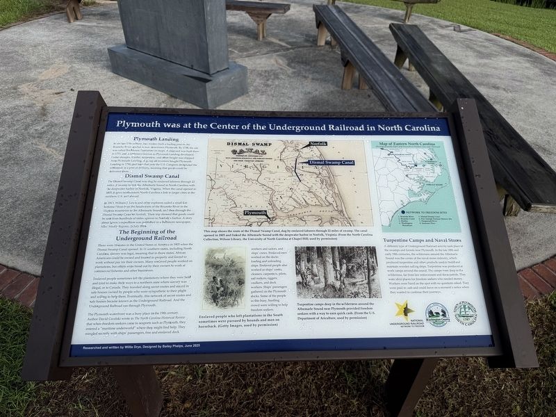
In 1815, William J. Lewis and other explorers sailed a small flat-bottomed boat from the headwaters of the Roanoke River in the Virginia mountains to the Albemarle Sound, and then through the Dismal Swamp Canal to Norfolk. Their trip showed that goods could
this page online
Enslaved people sometimes left the plantations where they were held and tried to make their ways to a northern state where slavery was illegal, or to Canada. They traveled along secret routes and stayed in safe houses owned by people who were sympathetic to their plight and willing to help them. Eventually, this network of secret routes and safe houses became known as the Underground Railroad. And the Underground Railroad ran through Plymouth.
The Plymouth waterfront was a busy place
Photographed by Devry Becker Jones (CC0), June 14, 2025
2. Plymouth was at the Center of the Underground Railroad in North Carolina Marker
[Captions:]
This map shows the route of the Dismal Swamp Canal, dug by enslaved laborers through 22 miles of swamp. The canal opened in 1805 and linked the Albemarle Sound with the deepwater harbor in Norfolk, Virginia. (From the North Carolina Collection, Wilson Library, the University of North Carolina at Chapel Hill; used by permission)
Enslaved people who left plantations in the South sometimes were pursued by hounds and men on horseback. (Getty Images, used by permission)
Turpentine camps deep in the wilderness around the Albemarle Sound near Plymouth provided freedom seekers with a way to earn quick cash. (From the U.S. Department of Agriculture, used by permission)
Erected 2025 by National Underground Railroad Network to Freedom; Washington County, North Carolina; Town of Plymouth, North Carolina.
Topics and series. This historical marker is listed in these topic lists: Abolition & Underground RR • African Americans • Industry & Commerce • Waterways & Vessels. In addition, it is included in the Network to Freedom series list. A significant historical month for this entry is July 1816.
Location. 35° 51.988′ N, 76° 45.229′ W. Marker is in Plymouth, North Carolina, in Washington County. It is at the intersection of West Water Street and Monroe Street, on the right when traveling west on West Water Street. Touch for map. Marker is at or near this postal address: 215 W Water St, Plymouth NC 27962, United States of America. Touch for directions.

Regionally, this marker is in North Carolina’s Coastal Plain. It is also in the American South, specifically in the Upper South, in the Tidewater, and on the Eastern Seaboard. Globally, it is in the North Atlantic Region, North America, the Western Hemisphere, the Western World, and the Anglosphere. Historically, it finds itself in what was once the territory of the Mississippian Culture, one of the original Thirteen Colonies, one of the Confederate States of America, and the Antebellum South.
Other nearby markers. At least 8 other markers are within walking distance of this marker: Plymouth Water Street Landing Park (here, next to this marker); Why Plymouth? (here, next to this marker); Roanoke River Lighthouse (a few steps from this marker); Hampton Academy (approx. 0.2 miles away); Brick House Landing (approx. 0.2 miles away); Augustin Daly (approx. ¼ mile away); Battle of Plymouth (approx. ¼ mile away); Cushing’s Torpedo (approx. ¼ mile away). Touch for a list and map of all markers in Plymouth.
Another marker is no longer nearby. Battle of Plymouth (was approx. ¼ mile away but has been replaced with another marker now near it).
Additional keywords. self-emancipation
Credits. This page was last revised on June 22, 2025. It was originally submitted on June 22, 2025, by Devry Becker Jones of Washington, District of Columbia. This page has been viewed 351 times since then and 75 times this year. Photos: 1, 2. submitted on June 22, 2025, by Devry Becker Jones of Washington, District of Columbia.
