Ocean Park in Santa Monica in Los Angeles County, California — The American West (Pacific Coastal)
Native Story

Photographed by Craig Baker, June 29, 2025
1. Native Story Marker
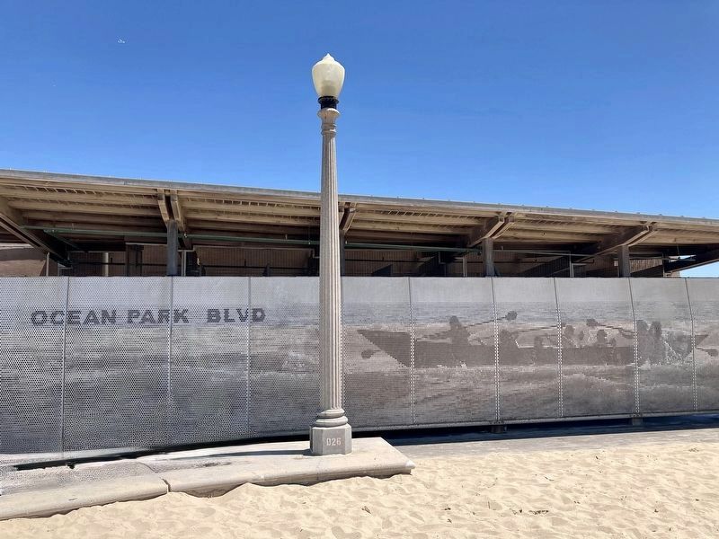
The Tongva or Gabrieleno tribe settled in the Santa Monica-Malibu area thousands of years ago. The Tongva were admired by Spanish explorers for their large seaworthy plank canoes called Te'aat that could hold up to 12 people. Driftwood planks were sewn together and their edges sealed with tar or pine pitch. Early populations were estimated at 5,500 and today approximately 1,500 people make up the growing Tongva tribe. The Tongva have a special relationship with the sea that is recounted in the legend of Torovim:
A Tongva chieftain was being pursued by an enemy tribe somewhere in Topanga - "Where the mountains meet the sea". He came to a cliff. Rather than submit to his captors, he dove into the sea. As he fell, he changed into the Dolphin, or Torovim - "Our brother of the ocean". He now swims around the world, staying ever vigilant and alert to ensure the safety of our people. It is his duty as caretaker of the ocean. And, when Torovim is no more, our people will also cease to be.
Erected by City of Santa Monica, California State Parks, and National Park Service.
Topics. This historical marker is listed in these topic lists: Indigenous Peoples and Communities • Waterways & Vessels.
Location. 33° 59.964′ N, 118° 29.164′ W. Marker is in Santa Monica, California, in Los Angeles County. It is in Ocean Park. It can be reached from Barnard Way just south of Ocean Park Boulevard, on the right when traveling south. Located on the restroom building next to beach parking lot 5-South. Touch for map. Marker is at or near this postal address: 2701 Barnard Way, Santa Monica CA 90405, United States of America. Touch for directions.

Regionally, this marker is in Greater Los Angeles and in the Transverse Ranges. It is also on the American
this page online
Other nearby markers. At least 8 other markers are within walking distance of this marker: Grunion Run (about 800 feet away, measured in a direct line); Roy Jones House (approx. 0.2 miles away); Pleasure Piers (approx. ¼ mile away); Ocean Park Branch Library (approx. ¼ mile away); Third Street Neighborhood Historic District (approx. 0.3 miles away); Shotgun House (approx. 0.3 miles away); a different marker also named Third Street Neighborhood Historic District (approx. 0.3 miles away); a different marker also named Third Street Neighborhood Historic District (approx. 0.3 miles away). Touch for a list and map of all markers in Santa Monica.
Related marker. Click here for another marker that is related to this marker. - Tongva Memorial at Loyola Marymount University.

Photographed by Craig Baker
2. Native Story Marker
Photographed by Craig Baker, June 29, 2025
3. Native Story Mural

courtesy NPS/Public Domain
4. Te'aat - or Tomol - a Tongva Canoe
Credits. This page was last revised on June 30, 2025. It was originally submitted on June 30, 2025, by Craig Baker of Sylmar, California. This page has been viewed 348 times since then and 23 times this year. Photos: 1, 2, 3, 4. submitted on June 30, 2025, by Craig Baker of Sylmar, California.
