Manchester in Coffee County, Tennessee — The American South (East South Central)
The Escarpment
| — | The Old Stone Fort State Archaeological Park | — |
Photographed by Darren Jefferson Clay, June 28, 2025
1. The Escarpment Marker
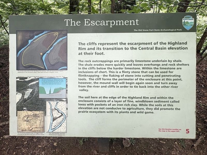
The rock outcroppings are primarily limestone underlain by shale. The shale erodes more quickly and leaves overhangs and rock shelters in the cliffs below the harder limestone. Within the limestone are inclusions of chert. This is a flinty stone that can be used for flintknapping - the flaking of stone into cutting and penetrating tools. The cliff forms the perimeter of the enclosure at this point, however, the mound wall will begin again soon and turn away from the river and cliffs in order to tie back into the other river valley.
The soil here at the edge of the Highland Rim and within the enclosure consists of a layer of fine, windblown sediment called loess with pockets of an iron rich clay. While the soils at this elevation are not conducive to agriculture, they did promote the prairie ecosystem with its plants and wild game.
Erected by Tennessee State Parks. (Marker Number 5.)
Topics. This historical marker is listed in these topic lists: Environment • Forts and Castles •
this page online
Location. 35° 29.346′ N, 86° 6.808′ W. Marker is in Manchester, Tennessee, in Coffee County. It can be reached from Stone Fort Dr south of U.S. 41, on the left when traveling south. Touch for map. Marker is in this post office area: Manchester TN 37355, United States of America. Touch for directions.

Regionally, this marker is in Middle Tennessee and in the Highland Rim. It is also in the American South and specifically in the Upper South. Globally, it is in North America, the Western Hemisphere, the Western World, and the Anglosphere. Historically, it finds itself in what was once the territory of the Mississippian Culture, one of the Confederate States of America, and the Antebellum South.
Other nearby markers. At least 8 other markers are within walking distance of this marker: The "Moat" is an Adandoned River Channel (about 400 feet away, measured in a direct line); Granny Hickerson Cemetery (approx. ¼ mile away); The Uses of Water in Different Cultures (approx. 0.4 miles away); Mills Interrupt the Walls (approx. half a mile away); The Old Stone Fort and the Stone Fort Paper Co.
Photographed by Darren Jefferson Clay, June 28, 2025
2. The Escarpment Marker
Credits. This page was last revised on July 8, 2025. It was originally submitted on July 6, 2025, by Darren Jefferson Clay of Duluth, Georgia. This page has been viewed 89 times since then and 25 times this year. Photos: 1, 2. submitted on July 6, 2025, by Darren Jefferson Clay of Duluth, Georgia. • James Hulse was the editor who published this page.
