Mackinac Island in Mackinac County, Michigan — The American Midwest (Great Lakes)
People of the Water
| — | Native American Cultural History Trail | — |
Photographed by Joel Seewald, July 1, 2025
1. People of the Water Marker, Side One
Side 1
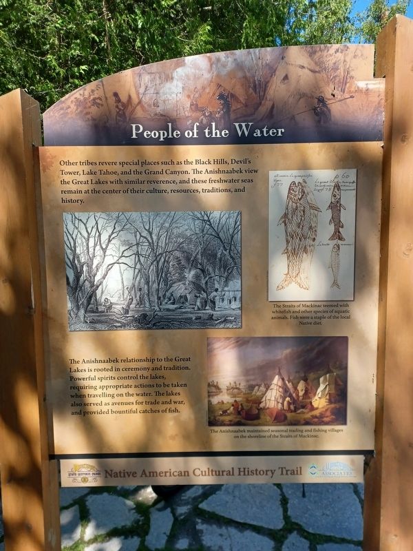
Other tribes revere special places such as the Black Hills, Devil's Tower, Lake Tahoe, and the Grand Canyon. The Anishnaabek view the Great Lakes with similar reverence, and these freshwater seas remain at the center of their culture, resources, traditions, and history.
The Anishnaabek relationship to the Great Lakes is rooted in ceremony and tradition. Powerful spirits control the lakes, requiring appropriate actions to be taken when travelling on the water. The lakes also served as avenues for trade and war, and provided bountiful catches of fish.
Top right image caption: The Straits of Mackinac teemed with whitefish and other species of aquatic animals. Fish were a staple of the local Native diet.
Bottom right image caption: The Anishnaabek maintained seasonal trading and fishing villages on the shoreline of the Straits of Mackinac.
Side 2
The Anishnaabek relied on extensive trade routes throughout the Great Lakes. The most prolific Anishnaabek traders were the Odawa, whose name translates to "trade" in Anishnaabamowin, their native language. Ojibway from Lake Superior traveled with the Odawa on
this page online
Once back at Mackinac, they journeyed to western villages to trade these goods for pelts. As fur sources declined at the turn of the 19th century, Anishnaabek trappers were forced into new trapping grounds. Odawa trappers went as far west as Lake Winnipeg, Manitoba, or in rare instances, to Lake Athapasca, Saskatchwan. The trip from Mackinac to Lake Athapasca was 1,300 miles!
Fishing was and continues to be an important resource for the Anishnaabek. Large villages could be sustained by whitefish and sturgeon. French explorer Antoine de la Mothe Cadillac described fishing at Mackinac in 1695:
The great abundance of fish and the convenience of the place for fishing have caused the Indians to make a fixed settlement in those parts. It is a daily manna, which never fails; there is no family which does not catch sufficient fish in the course of the year for its subsistence. Moreover, better fish cannot be eaten and they are bathed and nourished in the purest water, the clearest and the most pellucid you can see anywhere.The

Photographed by Joel Seewald, July 1, 2025
2. People of the Water Marker, Side Two
Lower image caption: Highly prized by European traders, beaver fur was used to make warm, waterproof hats. Anishnaabek men hunted the beaver, while women prepared the furs for trade.
Erected 2017 by Mackinac State Historic Parks and Mackinac Associates.
Topics. This historical marker is listed in these topic lists: Indigenous Peoples and Communities • Industry & Commerce • Waterways & Vessels. A significant historical year for this entry is 1695.
Location. 45° 52.955′ N, 84° 37.905′ W. Marker is on Mackinac Island, Michigan, in Mackinac County. It is on Lake Shore Boulevard (State Highway 185), on the left when traveling west. Marker is between mile markers 3 and 4 on the north shore of Mackinac Island. Touch for map. Marker is in this post office area: Mackinac Island MI 49757, United States of America. Touch for directions.

Regionally, this marker is on the Upper Peninsula and on the Straits of Mackinac. It is also in the American Midwest. Globally, it is in North America, in the Great North Woods, on the Great Lakes, in the Western
Photographed by Joel Seewald, July 1, 2025
3. People of the Water Marker
Other nearby markers. At least 8 other markers are within 2 miles of this marker, measured as the crow flies: Contest for the Island (approx. 0.7 miles away); Limestone Breccia (approx. ¾ mile away); The Ice Bridge (approx. ¾ mile away); The Mackinac Bridge (approx. ¾ mile away); British Landing (approx. ¾ mile away); The Treaty of Washington, 1836 (approx. 1½ miles away); Sugar Loaf (approx. 1.6 miles away); Resting Place of the Ancestors (approx. 1.6 miles away). Touch for a list and map of all markers in Mackinac Island.
Credits. This page was last revised on July 10, 2025. It was originally submitted on July 9, 2025, by Joel Seewald of Madison Heights, Michigan. This page has been viewed 120 times since then and 26 times this year. Photos: 1, 2, 3. submitted on July 9, 2025, by Joel Seewald of Madison Heights, Michigan.
