Westchester Township near Porter in Porter County, Indiana — The American Midwest (Great Lakes)
The Wreck of the J.D. Marshall

Photographed by Daniel Barriball, July 17, 2025
1. The Wreck of the J.D. Marshall Marker
The 154.5 foot steamship J.D. Marshall was built in 1891 to haul lumber. She was later converted to collect and transport sand. Fully loaded, she sprung a leak and sank in a storm on June 11, 1911. Three crewmen were trapped below deck and drowned. The remaining seven were washed overboard and all but one was saved.
Martin Donahue, First Mate
Gus Jake, Fireman
Charles Langeman, Assistant Engineer
John Wisemann, Seaman
Indiana Underwater Heritage Site
It is illegal to remove items from this wreck or the surrounding area per the Abandoned Shipwreck Act, passed in 1987 and Indiana state statute IC 14-21-1, passed in 1989. Please take only pictures and leave only bubbles.
"The man who has experienced shipwreck shudders even at a calm sea."—Ovid
Erected 2025 by Indiana Department of Natural Resources, Indiana State Parks and Indiana University Center for Underwater Science.
Topics. This historical marker is listed in these topic lists: Disasters • Parks & Recreational Areas • Waterways & Vessels. A significant historical date for this entry is June 11, 1911.
Location. 41° 39.745′ N, 87° 3.769′ W. Marker
this page online

Regionally, this marker is in Northwest Indiana, specifically on the Indiana Dunes and Lake Michigan Shore, and in the Calumet Region. It is also in the American Midwest and in the Corn Belt. Globally, it is in North America, on the Great Lakes, in the Western Hemisphere, in the Western World, and in the Anglosphere. Historically, it finds itself in what was once the territory of the Mississippian Culture and also the Northwest Territory.
Other nearby markers. At least 8 other markers are within walking distance of this marker: "Squall Causes Lake Disaster" (here, next to this marker); Dune Creek Watershed: What Makes It Special? (a few steps from this marker); The Chicago Skyline (about 300 feet away, measured in a direct
Photographed by Daniel Barriball, July 17, 2025
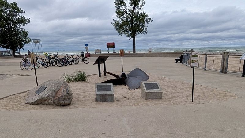
2. The Wreck of the J.D. Marshall Marker in context
The marker is on the left concrete block. The J.D. Marshall's propeller is behind this marker, and the back of the "Squall Causes Lake Disaster" marker is behind the propeller. The J.D. Marshall Preserve map is on the right concrete block.
Another marker is no longer nearby. The J.D. Marshall (was approx. 0.7 miles away but has been permanently removed).
Regarding The Wreck of the J.D. Marshall. The shipwreck is located under 30 feet of water approximately 2,400 feet offshore in front of the beach pavilion. It was named as Indiana's first underwater nature preserve in 2013. These markers were given to Indiana Dunes State Park by the Indiana University Center for Underwater Science. An identical pair mounted on Indiana limestone are on the lakebed at the shipwreck site.
Also see . . . JD Marshall Nature Preserve. Indiana Department of Natural Resources Information about the J.D. Marshall and the nature preserve. (Submitted on July 17, 2025, by Daniel Barriball of Chesterton, Indiana.)

Photographed by Daniel Barriball, July 17, 2025
3. J.D. Marshall Preserve Map
This map is on the concrete block to the right of the historical marker.
Credits. This page was last revised on August 6, 2025. It was originally submitted on July 17, 2025, by Daniel Barriball of Chesterton, Indiana. This page has been viewed 274 times since then and 88 times this year. Photos: 1, 2, 3. submitted on July 17, 2025, by Daniel Barriball of Chesterton, Indiana. • Andrew Ruppenstein was the editor who published this page.
