Welland in Niagara Region, Ontario — Central Canada (North America)
The Eight Bridges
Welland Feeder Canal
Photographed by Kevin Westell, July 21, 2025
1. The Eight Bridges - Marker
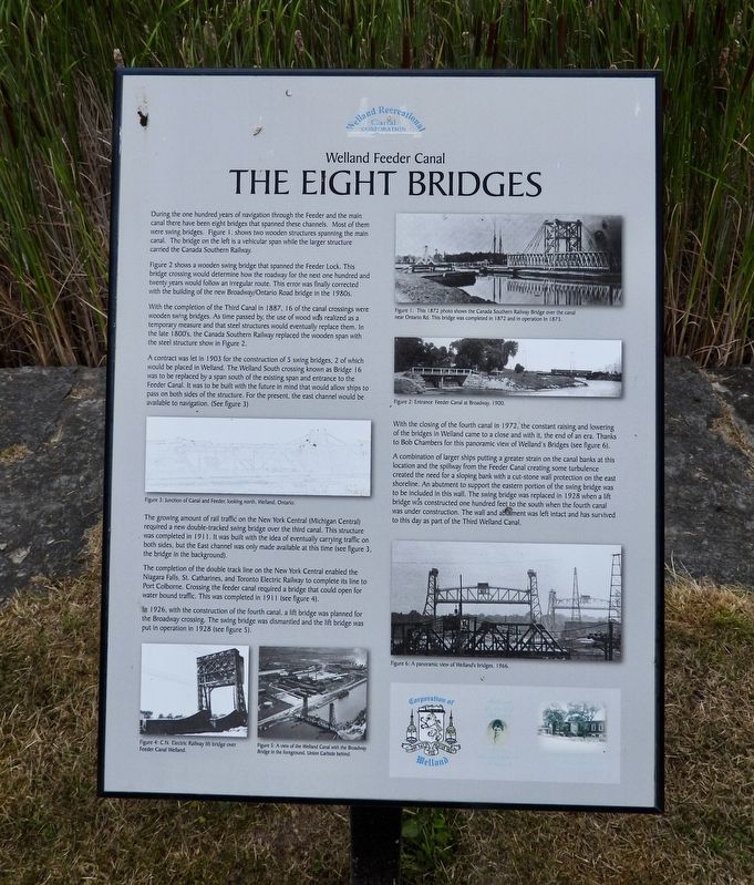
Figure 2 shows a wooden swing bridge that spanned the Feeder Lock. This bridge crossing would determine how the roadway for the next one hundred and twenty years would follow an irregular route. This error was finally corrected with the building of the new Broadway/Ontario Road bridge in the 1980s.
With the completion of the Third Canal in 1887, 16 of the canal crossings were wooden swing bridges. As time passed by, the use of wood was realized as a temporary measure and that steel structures would eventually replace them. In the late 1800's, the Canada Southern Railway replaced the wooden span with the steel structure shown in Figure 2.
A contract was let in 1903 for the construction of 5 swing bridges, 2 of which would be placed in Welland. The Welland South
this page online
The growing amount of rail traffic on the New York Central (Michigan Central) required a new double-tracked swing bridge over the third canal. This structure was completed in 1911. It was built with the idea of eventually carrying traffic on both sides, but the East channel was only made available at this time (see figure 3, the bridge in the background).
The completion of the double track line on the New York Central enabled the Niagara Falls, St. Catharines, and Toronto Electric Railway to complete its line to Port Colborne. Crossing the feeder canal required a bridge that could open for water bound traffic. This was completed in 1911 (see figure 4).
In 1926, with the construction of the fourth canal, a lift bridge was planned for the Broadway crossing. The swing bridge was dismantled and the lift bridge was
Photographed by Kevin Westell, July 21, 2025
2. The Eight Bridges - Marker in context
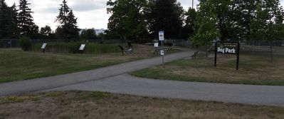
The photo faces east and south-east from Prince Charles Drive. The marker is one of the six around the marsh-pond within the feeder canal lock.
With the closing of the fourth canal in 1972, the constant raising and lowering of the bridges in Welland came to a close and with it, the end of an era. Thanks to Bob Chambers for this panoramic view of Welland's Bridges (see figure 6).
A combination of larger ships putting a greater strain on the canal banks at this location and the spillway from the Feeder Canal creating some turbulence created the need for a sloping bank with a cut-stone wall protection on the east shoreline. An abutment to support the eastern portion of the swing bridge was to be included in this wall. The swing bridge was replaced in 1928 when a lift bridge was constructed one hundred feet to the south when the fourth canal was under construction. The wall and abutment was left intact and has survived to this day as part of the Third Welland Canal.
Erected by Welland Canal Recreational Canal Corporation.
Topics and series. This historical marker is listed in these topic lists: Bridges & Viaducts • Railroads & Streetcars • Roads & Vehicles • Waterways & Vessels. In addition, it is included in the The Welland Canals series list. A significant historical year for this entry is 1872.
Location. 42° 58.45′ N, 79° 15.466′ W. Marker is in Welland, Ontario, in Niagara Region. It is at the intersection of Prince Charles Drive S and Ontario Road, on the right when traveling north on Prince Charles Drive S. The marker is one of six in a semi-circle around a small marsh-pond at the feeder canal lock, between two dog park fenced areas, 40 metres east of Prince Charles Drive and 40 metres east of Ontario Road. The best parking is at the dog park, off of Federal Road. Touch for map. Marker is at or near this postal address: 383 Prince Charles Drive S, Welland ON L3B 3P2, Canada. Touch for directions.

Regionally, this marker is on Ontario’s Golden Horseshoe and in Niagara Canada. It is also in Central Canada. Globally, it is in North America, on the Great Lakes, in the Western Hemisphere, in the Western World, and in the Anglosphere. Historically, it finds itself in what was once a British colony, the Viceroyalty of New France, the Haudenosaunee (Iroquois) Confederacy, and Rupert’s Land.
Other nearby markers. At least 8 other markers are within walking distance of this marker: The Raceway (here, next to this marker); The Origins (a few steps from this marker); Junction Village (a few steps from this marker); The Decline (a few steps from this marker); The Feeder Canal - Junction Lock - 1845 (a few steps from this marker); Economic Impact (a few steps from this marker); Artist - Catharine Mills "Hockey" (approx. 0.9 kilometers away); Ukrainian Labour Temple 2005 (approx. one kilometer away). Touch for a list and map of all markers in Welland.
Regarding The Eight Bridges. Explanatory notes:
1. The feeder canal flowed from Dunnville to this point, originally as a source for water to operate the first and second Welland canals; and once widened, also for ship transport.
2. For clarity: where the inscription refers to closing the fourth canal in 1972: the Welland canal by-pass (around the east side of Welland) opened in 1973, and this section of the fourth canal was closed to ship traffic. (The water still flows at a low rate.)
Credits. This page was last revised on July 23, 2025. It was originally submitted on July 23, 2025, by Kevin Westell of St. Catharines, Ontario. This page has been viewed 84 times since then and 13 times this year. Photos: 1, 2. submitted on July 23, 2025, by Kevin Westell of St. Catharines, Ontario. • Andrew Ruppenstein was the editor who published this page.
