
Near Winchester in Frederick County, Virginia — The American South (Mid-Atlantic)
Rose Hill
William W. Glass Farm
| — | 1862 Valley Campaign | — |
Photographed by Mark P Brock-Cancellieri, July 4, 2025
1. Rose Hill Marker
Marker format has been updated.
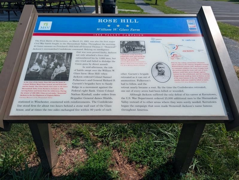
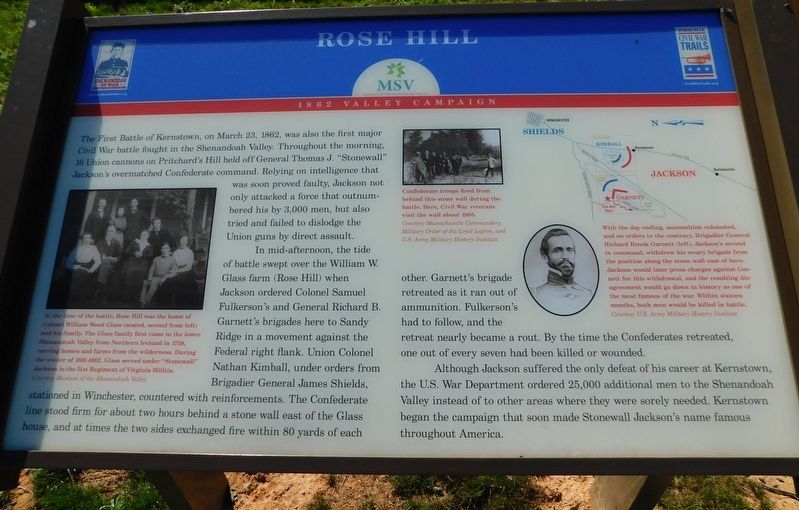
The First Battle of Kernstown, on March 23, 1862, was also the first major Civil War battle fought in the Shenandoah Valley. Throughout the morning, 16 Union cannons on Pritchard’s Hill held off Gen. Thomas J. “Stonewall” Jackson’s overmatched Confederate command. Relying on intelligence that was soon proved faulty, Jackson not only attacked a force that outnumbered his by 3,000 men, but also tried and failed to dislodge the Union guns by direct assault.
In mid-afternoon, the tide of battle swept over the William W. Glass farm (Rose Hill) when Jackson ordered Col. Samuel Fulkerson’s and Gen. Richard B. Garnett’s brigades here to Sandy Ridge in a movement against the Federal right flank. Union Col. Nathan Kimball, under orders from Brigadier General James Shields, stationed in Winchester, countered with reinforcements. The Confederate line stood firm for about two hours behind a stone wall east of the Glass house, and at times the two sides exchanged fire within 80 yards of each other. Garnett’s brigade retreated as it ran out of ammunition. Fulkerson’s had to follow, and the retreat nearly became a rout. By the time
this page online
Although Jackson suffered the only defeat of his career at Kernstown, the U.S. War Department ordered 25,000 additional men to the Shenandoah Valley instead of to other areas where they were sorely needed. Kernstown began the campaign that soon made Stonewall Jackson’s name famous throughout America.
(captions)
At the time of the battle, Rose Hill was the home of Colonel William Wood Glass (seated, second from left) and his family. The Glass family first came to the lower Shenandoah Valley from Northern Ireland in 1738, carving homes and farms from the wilderness. During the winter of 1861–1862, Col. Glass served under "Stonewall" Jackson in the 51st Regiment of Virginia Militia. Courtesy Museum of the Shenandoah Valley
Confederate troops fired from behind this stone wall during the battle. here, Civil War veterans visit the wall about 1885. Courtesy Massachusetts Commandery, Military Order of the Loyal Legion, and U.S. Army Military History Institute
With the day ending, ammunition exhausted, and no orders to the contrary, Brigadier General Richard Brook Garnett (left), Jackson’s second in command, withdrew his weary brigade from the position along the stone wall east of here. Jackson would later press charges against Garnett for this withdrawal, and the resulting disagreement would go down in history as one of the most famous of the war. Within sixteen months both men would be killed in battle. Courtesy U.S. Army Military History Institute
Erected by Virginia
Photographed by Bradley Owen, August 29, 2026
2. Rose Hill Marker
Marker is on the right.
Topics and series. This historical marker is listed in this topic list: War, US Civil. In addition, it is included in the Virginia Civil War Trails series list. A significant historical date for this entry is March 23, 1862.
Location. 39° 9.191′ N, 78° 13.189′ W. Marker is near Winchester, Virginia, in Frederick County. It is on Jones Road (Virginia Route 621) 0.4 miles south of Cedar Creek Grade ( Route 622), on the left when traveling south. Marker is at the beginning of the walking trail off the parking lot at the entrance to Rose Hill Park. Touch for map. Marker is at or near this postal address: 1871 Jones Road, Winchester VA 22602, United States of America. Touch for directions.

Regionally, this marker is in Virginia’s Shenandoah Valley. It is also in the American South, specifically in the Upper South, and in the Mid-Atlantic. Globally, it is in North America, the Western Hemisphere, the Western World, and the Anglosphere. Historically, it finds itself in what was once the territory of the Mississippian Culture, one of the original Thirteen Colonies, one of the Confederate
Photographed by Bradley Owen, October 18, 2017
3. Rose Hill Marker
Previous format.
Other nearby markers. At least 8 other markers are within walking distance of this marker: The First Battle Of Kernstown (here, next to this marker); War In The Backyard (about 400 feet away, measured in a direct line); Fight for the High Ground (about 700 feet away); a different marker also named Northern Victory, Southern Defeat (approx. 0.2 miles away); a different marker also named The Defense of the Stone Wall (approx. ¼ mile away); The Order For Retreat (approx. 0.3 miles away); a different marker also named The Advance of Tyler's Brigade (approx. 0.3 miles away); Caring For the Wounded and Dead (approx. 0.6 miles away). Touch for a list and map of all markers in Winchester.
Other markers no longer nearby. How To See the Battlefield (was about 500 feet away but has been permanently removed); War in the Backyard (was about 500 feet away but has been permanently removed); a different marker also named Rose Hill (was about 700 feet away but has been replaced with another marker now near it); Northern Victory, Southern Defeat (was approx. 0.2 miles away but has been replaced with another marker now near it); The Defense of the Stone Wall (was approx. 0.2 miles away but has been replaced with another marker now near it); The Order for Retreat (was approx. ¼ mile away but has been replaced with another marker now near it); The Advance of Tyler’s Brigade (was approx. ¼ mile away but has been replaced with another marker now near it).
Credits. This page was last revised on September 7, 2026. It was originally submitted on April 7, 2021, by Bradley Owen of Morgantown, West Virginia. This page has been viewed 887 times since then and 57 times this year. Last updated on July 24, 2025, by Carl Gordon Moore Jr. of North East, Maryland. Photos: 1. submitted on July 24, 2025, by Mark P. Brock-Cancellieri of Baltimore, Maryland. 2. submitted on September 7, 2026, by Bradley Owen of Morgantown, West Virginia. 3. submitted on April 3, 2021, by Bradley Owen of Morgantown, West Virginia. • Bernard Fisher was the editor who published this page.
