
Thorold in Niagara Region, Ontario — Central Canada (North America)
Battle of Beaverdams Park

Photographed by Kevin Westell, July 28, 2025
1. Battle of Beaverdams Park Marker
The History of Lock 25
Lock 25, located in the Battle of Beaverdams Park in downtown Thorold, is one of the 27 stone locks of the 2nd Welland Canal, which were constructed between 1841 and 1845 to replace the 40 inferior wooden locks of the 1st canal. Its role, of historic significance not only for Niagara Region but the entire Great Lakes waterway system, was facilitating marine travel between Lakes Ontario and Erie.
After having been filled in during the late 1950s and 60s, like all the 2nd Canal locks which flowed through downtown Thorold, Lock 25 was partially excavated in 1976 when the Battle of Beaverdams Park was opened.
Along with 16 other locks of the 2nd Welland Canal, Lock 25 was constructed from limestone quarried locally, at what is now Walker's Quarry.
The lock's important contextual value lies in its association with Thorold's 2nd Canal lands which were completely buried in the mid-20th century. Evidence of the presence of this waterway is found in the swale-like topography of central Thorold. The lock is also located within a 500-meter radius of numerous designated and non-designated
this page online
Lock 25 is part of the built heritage and cultural landscape of downtown Thorold, as a reminder of the various Welland Canals' impact on the historic character of the community. It demonstrates how industrial heritage can be revitalized and incorporated into the cultural heritage landscape. As such, it fulfills the goal of establishing a link to the past that can serve to support contemporary aspirations and ideals.
Erected 2024 by City of Thorold.
Topics and series. This historical marker is listed in these topic lists: Parks & Recreational Areas • Waterways & Vessels. In addition, it is included in the The Welland Canals series list. A significant historical year for this entry is 1841.
Location. 43° 7.369′ N, 79° 12.094′ W. Marker is in Thorold, Ontario, in Niagara Region. It is on Sullivan Avenue, on the right when traveling east. The marker is within The Battle of Beaverdams Park, adjacent to the walking path that comes from the Sullivan Avenue gate. Touch for map. Marker is at or near this postal address: 7 Sullivan Avenue, Thorold ON L2V 2X9, Canada. Touch for directions.

Regionally,
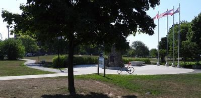
Photographed by Kevin Westell, July 28, 2025
2. Battle of Beaverdams Park - Marker in context
Other nearby markers. At least 8 other markers are within walking distance of this marker: Beaver Dams (here, next to this marker); Laura Ingersoll Secord (a few steps from this marker); Arthur S. Whelan (within shouting distance of this marker); a different marker also named Beaver Dams (within shouting distance of this marker); In Memory of Unknown American Soldiers (within shouting distance of this marker); City of Thorold Time Capsule (within shouting distance of this marker); In Memory of John Bean, Ph.D., M.D. (about 90 meters away, measured in a direct line); The JB Stone (about 90 meters away). Touch for a list and map of all markers in Thorold.
Credits. This page was last revised on July 29, 2025. It was originally submitted on July 28, 2025, by Kevin Westell of St. Catharines, Ontario. This page has been viewed 168 times since then and 20 times this year. Photos: 1, 2. submitted on July 28, 2025, by Kevin Westell of St. Catharines, Ontario. • Andrew Ruppenstein was the editor who published this page.
