Ostia Antica in Città metropolitana di Roma Capitale, Latium, Rome, Italy — Central Italy (Tyrrhenian Coast)
La Necropoli della Via Ostiense
⎯⎯⎯
The Via Ostiensis Necropolis

Photographed by Sean P. Flynn, August 5, 2025
1. La Necropoli della Via Ostiense / The Via Ostiensis Necropolis Marker
Starting from the 2nd century BC, tombs of various types began to be built on the south side of the Via Ostiensis outside the city, gradually increasing in number to occupy increasingly large areas and sometimes superimposed on one another. There are no tombs on the north side of the road because the strip next to the Tiber was considered public land. The first funerary monuments were open-air enclosures in which cremations took place; later, columbarium tombs were built with cinerary urns placed in small niches along the walls. Between the 2nd and 3rd centuries AD, burial prevailed: the deceased were placed in terracotta or marble sarcophagi, but also in simple graves dug into the ground and covered with tiles. Based on the surviving inscriptions, we can identify magistrates and prominent individuals from Ostia among the owners of the sixty or so funerary monuments found in this area.
Erected by Italian
this page online
Topics. This historical marker is listed in these topic lists: Anthropology & Archaeology • Cemeteries & Burial Sites.
Location. 41° 45.472′ N, 12° 17.81′ E. Marker is in Ostia Antica, Lazio (Latium, Rome), in Città metropolitana di Roma Capitale. It can be reached from Viale degli Scavi. The marker is in Ostia Antica Archaeological Park, a short walk from the entrance. Touch for map. Marker is in this post office area: Ostia Antica, Lazio 00119, Italy. Touch for directions.

Regionally, it is in Europe, the European Union, the Schengen Area, a coastal Mediterranean country, and the Western World. Historically, it finds itself in what was once the Roman Empire.
Other nearby markers. At least 8 other markers are within walking distance of this marker: Ostia Antica: Storia e Sviluppo Urbano / Ancient Ostia: History and Urban Development (a few steps from this marker); Tomba degli Archetti / Tomb of the Arches (within shouting distance of this marker); The Archeological Area of Ostia Antica / L'Area Archeologica di Ostia Antica
Photographed by Sean P. Flynn, August 5, 2025
2. La Necropoli della Via Ostiense / The Via Ostiensis Necropolis Marker
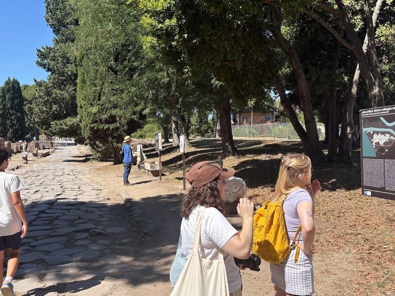
This view shows the main road into the city, whose ancient walls are about 125 meters ahead. A map of the archeological park is near this historical marker, and another historical marker can be found about 15 meters east (to the right).
More about this marker. The marker is found along the city's main entry road, known as Decumanus Maximus. It is about 125 meters east of the Porto Romano, which was the ancient gateway into the city.
Also see . . . Porta Romana necropolis.
Excerpt: "The Porta Romana necropolis consists of some sixty tombs, located just outside the Roman Gate. It was unearthed by Pietro Ercole Visconti in the years 1855-1859, by Dante Vaglieri in the years 1909-1913, and by Guido Calza in the period 1919-1923. The necropolis continued(Submitted on August 8, 2025, by Sean P. Flynn of Oak Park, Illinois.)further to the east, but this part has not been excavated systematically. The necropolis has been studied in great detail by Michael Heinzelmann."Photographed by Sean P. Flynn, August 5, 20253. Necropoli outside the city walls of ancient OstiaThis photo is taken from near the historical marker.


Photographed by Sean P. Flynn, August 5, 2025
4. Inscription from the nearby necropolis of Caius Domitius Fabius Hermogenes
Credits. This page was last revised on August 8, 2025. It was originally submitted on August 8, 2025, by Sean P. Flynn of Oak Park, Illinois. This page has been viewed 115 times since then and 45 times this year. Photos: 1, 2, 3, 4. submitted on August 8, 2025, by Sean P. Flynn of Oak Park, Illinois.
