Port Colborne in Niagara Region, Ontario — Central Canada (North America)
Settlement Begins - Port Colborne's Early Inhabitants
La Colonisation - Les Premiers Habitants De Port Colborne
Photographed by Kevin Westell, August 14, 2025
1. Settlement Begins - Port Colborne's Earl Inhabitants - Marker

Settlement Begins - Port Colborne's Early Inhabitants
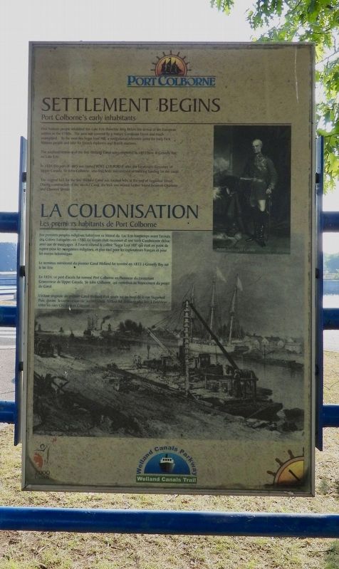
First Nations people inhabited this Lake Erie shoreline long before the arrival of the European settlers in the 1780s. The area was covered by a mature Carolinian forest and much swampland. To the west lies Sugar Loaf Hill, a navigational reference point for early First Nations people and later for French explorers and British mariners.
The southern terminus of the first Welland canal was completed in 1833 here at Gravelly Bay on Lake Erie.
In 1834 this port of entry was named Port Colborne after the Lieutenant-Governor of Upper Canada, Sir John Colborne, who had been instrumental in securing funding for the canal.
The original lock for the first Welland canal was located here at the end of Sugarloaf Street. During construction of the second Canal, the lock was moved further inland between Charlotte and Clarence Streets.
La Colonisation - Les Premiers Habitants De Port Colborne
Les premiers peuples indigènes habitèrent ce littoral du Lac Erie longtemps avant l'arrivée des colons Européens en 1780. Le terrein était recouvert d'une forêt Carolinienne dense ainsi que de marécages. A l'ouest s'étend la colline "Sugar Loaf Hill" qui était un point de repère pour les navigateurs indigènes, et plus tard pour les explorateurs français et pour les marins britanniques.
Le terminus méridional du premier Canal Welland fut terminé en 1833 à Gravelly Bay sur le lac Erie.
En 1834, ce port d'accès fut nommé Port Colborne en l'honneur du Lieutenant Gouverneur de Upper Canada, Sir John Colborne, qui contribua au financement du project du Canal.
L'écluse originale du premier canal Welland était située ici au bout de la rue Sugarloaf. Puis, durant la construction du second canal, l'écluse fut déplacée plus
this page online
Erected 2000.
Topics and series. This historical marker is listed in these topic lists: Colonial Era • Settlements & Settlers • Waterways & Vessels. In addition, it is included in the The Welland Canals series list. A significant historical year for this entry is 6000 BCE.
Location. 42° 52.849′ N, 79° 14.982′ W. Marker is in Port Colborne, Ontario, in Niagara Region. It is at the intersection of Sugarloaf Street and West Street, on the right when traveling east on Sugarloaf Street. Touch for map. Marker is in this post office area: Port Colborne ON L3K 4E6, Canada. Touch for directions.

Regionally, this marker is on the Golden Horseshoe and in Niagara Canada. It is also in Central Canada. Globally, it is in North America, on the Great Lakes, in the Western Hemisphere, in the Western World, and in the Anglosphere. Historically, it finds itself in what was once a British colony, the Viceroyalty of New France, the Haudenosaunee (Iroquois) Confederacy, and Rupert’s Land.
Other nearby markers. At least 8 other markers are within walking distance

Photographed by Kevin Westell, August 14, 2025
2. Settlement Begins - Port Colborne's Earl Inhabitants - The reverse side
This is a map of Port Colborne, showing the locations of this series of historic panels. (Most currently exist.)

Photographed by Kevin Westell, August 14, 2025
3. Settlement Begins - Port Colborne's Earl Inhabitants - Marker in context
Photo faces south across Sugarloaf St . West Street runs down the left side of the photo. The marker is adjacent to the paved walking/biking trail, 5 metres from the intersection.
Credits. This page was last revised on August 20, 2025. It was originally submitted on August 15, 2025, by Kevin Westell of St. Catharines, Ontario. This page has been viewed 207 times since then and 65 times this year. Photos: 1, 2, 3. submitted on August 15, 2025, by Kevin Westell of St. Catharines, Ontario. • Andrew Ruppenstein was the editor who published this page.
