Near Chesterton in Porter County, Indiana — The American Midwest (Great Lakes)
Indiana State Parks: the First 100 Years 1916-2016
| — | Indiana Dunes State Park | — |

Photographed by Daniel Barriball, March 9, 2025
1. Indiana State Parks: the First 100 Years 1916-2016 Marker
…our parks and preserves are not mere picnicking places. They are rich storehouses of memories and reveries. They are a solace to the aged and an inspiration to the young.
Richard Lieber, Founder
Indiana State Parks
Setting the Stage
Alarm over the nation's disappearing natural landscape gave birth to the parks movement. Richard Lieber and others advocated for the creation of a state park system as Indiana's 1916 centennial gift.
First Parks
Land for Turkey Run came up for sale at an auction, but was lost to a higher bidder. McCormick's Creek was purchased in time for the State's centennial celebration. Within the year, however, Lieber's group purchased Turkey Run. By 1932, ten parks dotted the state.
State Park Inns
Inns provided accommodations for early park visitors. Many early visitors would stay for over a week.
Gatehouses
Indiana State Parks was a leader in implementing a "User Pays" model to support operating costs.
Nature Guides
Almost from the beginning, Indiana State Parks provided nature guides to interpret the natural and cultural stories of the parks.
Civilian Conservation Corps
During
this page online
Post-World War II
Following the war, many veterans earned college degrees, entered the work force and started families. Increased income led to more travel and a demand for parks.
Reservoirs
Beginning in the 1950s, the US Army Corps of Engineers constructed dams for flood control. Land was managed for camping, hunting and fishing by the Division of Reservoir Management (later merging with State Parks).
Conserving Resources
The 1960s brought new understanding and concern for the environment. State Parks began management practices to conserve and maintain valuable ecosystems.
The Next 100 Years
We continue to be a leader in state park conservation and management. We hope you and future generations will continue to use and support Indiana State Parks. Make your own memories!
1. 1916 – McCormick's Creek
2. 1916 – Turkey Run
3. 1920 – Clifty Falls
4. 1925 – Pokagon
5. 1925 – Indiana Dunes
6. 1927 – Spring Mill
7. 1929 – Brown County
8. 1929 –Shakamak
9. 1930 – Mounds
10. 1932– LincolnPhotographed by Daniel Barriball, March 9, 20252. Indiana State Parks Centennial PlaqueTo the left of the marker.
11. 1943 – Tippecanoe River
12. 1943 – Versailles
13. 1947 – Shades
14. 1949 – Whitewater Mem.
15. 1953 – Lieber SRA
16. 1960 – Chain O' Lakes
17. 1960 – Raccoon Lake
18. 1962 – Ouabache
19. 1966 – Harmonie
20. 1966 – Monroe Lake
21. 1967 – Salmonie Lake
22. 1968 – Mississinewa Lake
23. 1969 – Potato Creek
24. 1973 – Hardy Lake
25. 1975 – Brookville Lake
26. 1980 – Patoka Lake
27. 1988 – Summit Lake
28. 1990 – Falls of the Ohio
29. 1996 – Charlestown
30. 1996 – Fort Harrison
31. 2004 – O'Bannon Woods
32. 2004 – Prophetstown
33. 2007 – Trine SRA

Erected 2016 by Indiana Department of Natural Resources, Indiana State Parks.
Topics. This historical marker is listed in these topic lists: Environment • Parks & Recreational Areas. A significant historical year for this entry is 1916.
Location. 41° 39.388′ N, 87° 3.647′ W. Marker is near Chesterton, Indiana, in Porter County. It is on County Road 100E, on the left when traveling east. The marker is just north of the southern entrance to the picnic area off of the park road in Indiana Dunes State Park. Touch for map. Marker is in this post office area:
Photographed by Daniel Barriball, March 9, 2025
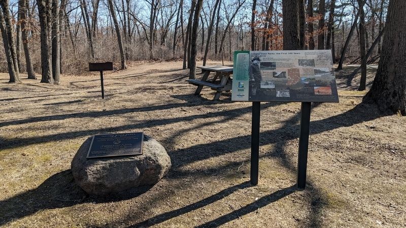
3. Wide angle view of Indiana State Parks: the First 100 Years 1916-2016 Marker

Regionally, this marker is in Northwest Indiana, specifically on the Indiana Dunes and Lake Michigan Shore, and in the Calumet Region. It is also in the American Midwest and in the Corn Belt. Globally, it is in North America, on the Great Lakes, in the Western Hemisphere, in the Western World, and in the Anglosphere. Historically, it finds itself in what was once the territory of the Mississippian Culture and also the Northwest Territory.
Other nearby markers. At least 8 other markers are within walking distance of this marker: Daylighting: Getting Dunes Creek Out of the Pipe (approx. 0.3 miles away); Le Petit Fort (approx. 0.3 miles away); The Wreck of the J.D. Marshall (approx. 0.4 miles away); "Squall Causes Lake Disaster" (approx. 0.4 miles away); Dune Creek Watershed: What Makes It Special? (approx. 0.4 miles away); The Chicago Skyline (approx. 0.4 miles away); Mt. Tom: A View of Ancient Shorelines (approx. half a mile away); 100 Years Indiana Dunes State Park (approx. 0.6 miles away). Touch for a list and map of all markers in Chesterton.
Another marker is no longer nearby. The J.D. Marshall (was approx. 0.6 miles away but has been permanently removed).
More about this marker. Duplicates of this marker were placed at every Indiana state park and reservoir during the centennial year of 2016.
Credits. This page was last revised on August 18, 2025. It was originally submitted on March 9, 2025, by Daniel Barriball of Chesterton, Indiana. This page has been viewed 244 times since then and 52 times this year. Last updated on August 16, 2025, by Daniel Barriball of Chesterton, Indiana. Photos: 1, 2, 3. submitted on March 9, 2025, by Daniel Barriball of Chesterton, Indiana. • Devry Becker Jones was the editor who published this page.
