South Murderkill Hundred in Magnolia in Kent County, Delaware — The American Northeast (Mid-Atlantic)
Murderkill/Motherkiln Friends Meeting
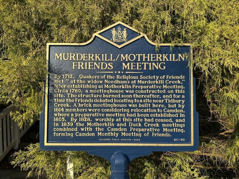
Photographed by Pete Skillman, August 26, 2025
1. Murderkill/Motherkiln Friends Meeting Marker
Erected 2022 by Delaware Public Archives. (Marker Number KC-90.)
Topics and series. This historical marker is listed in these topic lists: Cemeteries & Burial Sites • Colonial Era • Religion & Religious Structures. In addition, it is included in the Delaware Public Archives, and the Quakerism series lists. A significant historical year for this entry is 1712.
Location. 39° 4.544′ N, 75° 28.755′ W. Marker is in Magnolia, Delaware, in Kent County. It is in South
this page online

Regionally, this marker is in the American Mid-Atlantic, on the Delmarva Peninsula, and on the Eastern Seaboard. Globally, it is in the North Atlantic Region, North America, the Western Hemisphere, the Western World, and the Anglosphere. Historically, it finds itself in what was once New Netherland, one of the original Thirteen Colonies, and the Antebellum South.
Other nearby markers. At least 8 other markers are within 3 miles of this marker, measured as the crow flies: Warner Mifflin 1745-1798 (here, next to this marker); Banning Meeting House (approx. 1.4 miles away); The St. Jones River: Why the Mansion Faces South (approx. 2.4 miles away); The Dickinsons in Delaware (approx. 2½ miles away); Toward a Future Union (approx. 2½ miles away); Home of John Dickinson (approx. 2½ miles away); St. Jones Neck (approx. 2.7 miles away); U-3A (approx. 3.1 miles away). Touch for a list and map of all markers

Photographed by Pete Skillman, August 26, 2025
2. Murderkill/Motherkiln Friends Meeting Marker - wide view
Other markers no longer nearby. Warner Mifflin (was here, next to this marker but has been replaced with another marker now near it); Murderkill / Motherkiln Friends Meeting (was here, next to this marker but has been replaced with another marker now near it).
Credits. This page was last revised on May 15, 2026. It was originally submitted on August 26, 2025, by Pete Skillman of Wilmington, Delaware. This page has been viewed 93 times since then and 27 times this year. Photos: 1, 2. submitted on August 26, 2025, by Pete Skillman of Wilmington, Delaware.
