Port Dalhousie in St. Catharines in Niagara Region, Ontario — Central Canada (North America)
Green Ribbon Trail - Eco-Tour
Welcome
Photographed by Kevin Westell, September 12, 2025
1. Green Ribbon Trail - Eco-Tour - Marker
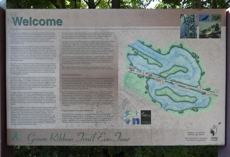
Wetlands are some of the most diverse ecosystems on earth because they have both land and aquatic characteristics. The wide variety of plant species in a wetland provides habitat for the different animal communities. Microorganisms, invertebrates, reptiles, mammals, and amphibians are all commonly found living in wetlands. Many fish species require wetland habitat for spawning, feeding, or protection from predators. Birds, especially waterfowl, are attracted to wetlands by the abundance of food and spots for nesting, resting, and feeding. In Canada, wetlands are home to many threatened or endangered species of fish, birds, amphibians,
this page online
Physically, wetlands help control floods by storing water and slowly releasing it to downstream areas. Wetlands can reduce wave action and slow down the flow of water, lessening erosion and causing sediments to settle out of the water. This improves water quality, as does the removal of nutrients and contaminants from the water by wetland plants and by chemical processes in wetland sediments. Wetlands may also serve as sites where surface water can seep into the ground and replenish the groundwater.
The wetland you are about to explore is made up of the Barnesdale Marsh and Richardson's Creek. The Barnesdale Marsh is a Class 1 provincially significant and protected wetland. It sits within the flood banks of Richardson's Creek as it flows north to Martindale Pond. As you travel along the paved trail you will go down into the creek's lowlands. You will pass through the marsh and over the creek at its northern end, just before it meanders into Martindale Pond. Looking upstream from the bridge you will be able to see the marsh characterized by emergent plants and the call of birds.
This urban marsh
Photographed by Kevin Westell, September 12, 2025
2. Green Ribbon Trail
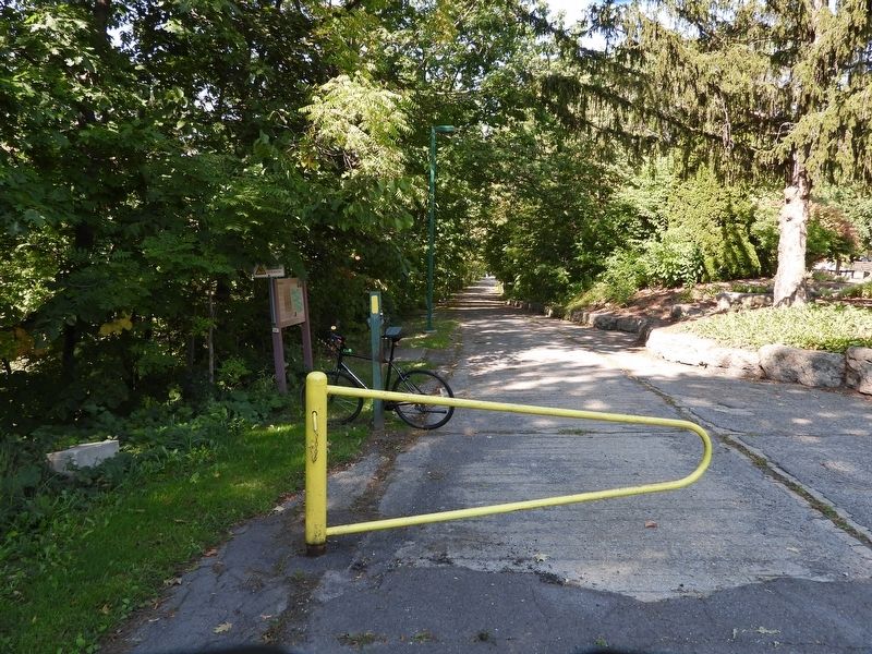
Photo faces west, from the parking lot. The asphalt was scraped off the old road, leaving the concrete base to walk on.
Along the Green Ribbon Trail you will find nine signs describing different plants and animals and how they interact within an ecosystem. Each sign gives you specific and general information on each topic, including the common and scientific name of the individual species living here, the species' role in the Barnesdale Marsh / Richardson's Creek food web, and the habitat these individuals enjoy. A food chain is a sequence of feeding relationships among living organisms, which shows the movement of energy from one organism to the next. At each station information is given describing a chain commonly found in a wetland setting although it may not necessarily be occurring within this one. To show how life within the wetland continues to expand and grow a life cycle example is included at each station.
Due to our temperate climate the descriptions given on each sign may not be appropriate all year round. The best viewing takes place during the growing season. During the winter many marsh animals have migrated south to warmer climates. Those that remain are hibernating, resting, or are active searching for food in the harsh winter.
In the winter, aquatic animals like the muskrat stay under the ice feeding on plants, crayfish, freshwater clams, and mussels. Cold blooded animals like fish and amphibians sleep during the winter. Many burrow into the mud and plant material on the pond's bottom to sleep although some fish, such as yellow perch and northern pike, stay awake in the deep unfrozen water. Once the warmth of spring arrives and the animal's body temperature increases they become fully active again. Many insect species stay active during the winter. Some can be found in air pockets under the ice or clinging to underwater plants. During a thaw many can be seen gliding across the surface or swimming around underwater.
As you tour the wetland please keep to the paved trail. A number of plants are considered unusual or rare and they do not respond well to being trampled. Also there are clusters of poison ivy at the edges of the wooded area which, if touched, could cause discomfort. If you are taking the tour during the winter please do not walk on the ice and be careful for thin patches along the shoreline, rocks and stumps.
Please respect the habitat and do not disturb or remove any plants, soil, water or other element of the ecosystem. Please put all garbage in its proper spot. Thank you and enjoy.
Green Ribbon Trail History
The City of St. Catharines along with Child Find, the John Howard Society, private sector companies and many volunteers created the Green Ribbon Trail. The walkway was built over top of the Old Martindale Road. A new parking lot was built on top of the bank and a welcome garden established to greet visitors to the trail. Volunteers built and installed a new bridge to link both sides of the trail and permit people to stroll, bike, job or roller blade uninterrupted through the serene wetland. The Green Ribbon Trail was dedicated to all missing children in memory of Kristen French.
In 1997, to prepare for the 1999 World Rowing Championships, the City of St. Catharines Public Works and Government Services Canada, Environment Canada, the Ministry of Natural Resources, the Ministry of the Environment, and the Canadian Henley Rowing Corporation developed an Ecosystem Management Plan for Martindale Pond. One aspect of the plan was to enhance wildlife habitat and create sediment control structures in Richardson's Creek. To do this two barrier beaches were constructed, one upstream and the other downstream of the walking bridge. Home to waterfowl, insects, plants and marsh birds these islands provide a diverse environment and some of the best wildlife viewing in St. Catharines.
Project Partners of The Green Ribbon Trail
This Eco-Tour was developed as a co operative effort between The Canada Millennium Partnership Program, The Corporation of the City of St. Catharines, Niagara College, The District School Board of Niagara, The Niagara Catholic District School Board, The Niagara Peninsula Conservation Authority, The Ministry of the Environment, and The Friends of Twelve Mile Creek.
Topics. This historical marker is listed in these topic lists: Education • Environment • Parks & Recreational Areas. A significant historical year for this entry is 1997.
Location. 43° 11.095′ N, 79° 16.936′ W. Marker is in St. Catharines, Ontario, in Niagara Region. It is in Port Dalhousie. It is on Martindale Road 0 kilometers north of Courtland St, on the right when traveling south. The marker is 15 metres south-west of the road, 10 metres west of the walking trail's small parking lot, beside the yellow metal gate at the start of the trail. Touch for map. Marker is at or near this postal address: Martindale Road, St Catharines ON L2N 7M2, Canada. Touch for directions.

Regionally, this marker is on the Golden Horseshoe and in Niagara Canada. It is also in Central Canada. Globally, it is in North America, on the Great Lakes, in the Western Hemisphere, in the Western World, and in the Anglosphere. Historically, it finds itself in what was once a British colony, the Viceroyalty of New France, the Haudenosaunee (Iroquois) Confederacy, and Rupert’s Land.
Other nearby markers. At least 8 other markers are within 3 kilometers of this marker, measured as the crow flies: The Burgoyne, Nelson, Newman Boathouse (approx. 1.2 kilometers away); Mayholme (approx. 1.5 kilometers away); Green Ribbon Memorial Garden (approx. 1.5 kilometers away); Third Welland Canal 1887 - 1930 (approx. 1.5 kilometers away); Former Home - Sid Brookson 1919 (approx. 1.7 kilometers away); St John's Anglican Church 1868 (approx. 1.9 kilometers away); Main Street at Ann Street (approx. 1.9 kilometers away); Port Dalhousie Cenotaph (approx. 1.9 kilometers away). Touch for a list and map of all markers in St. Catharines.
Regarding Green Ribbon Trail - Eco-Tour. This 1990s "eco" project was interesting, in successfully returning an urban feature (road and bridge) to a quasi-natural state. The trail itself is short, ½ kilometre, down into a creek valley and up the other side, built around 1995. The original stepping stones (more fun but seasonally troublesome) across the creek were replaced by the safer and more accessible walking bridge. This "welcome" sign and the related nine nature signs along the trail were erected around 1999. Today (2025), most (if not all) of the nature signs are gone, as a result of "human erosion".
Credits. This page was last revised on September 14, 2025. It was originally submitted on September 13, 2025, by Kevin Westell of St. Catharines, Ontario. This page has been viewed 82 times since then and 29 times this year. Photos: 1, 2. submitted on September 13, 2025, by Kevin Westell of St. Catharines, Ontario. • Andrew Ruppenstein was the editor who published this page.
