Near Harmon in Burleigh County, North Dakota — The American Midwest (Upper Plains)
Geophysical Prospecting in Archaeology
Double Ditch Indian Village State Historic Site
Photographed by Barry Swackhamer, July 22, 2025
1. Geophysical Prospecting in Archaeology Marker
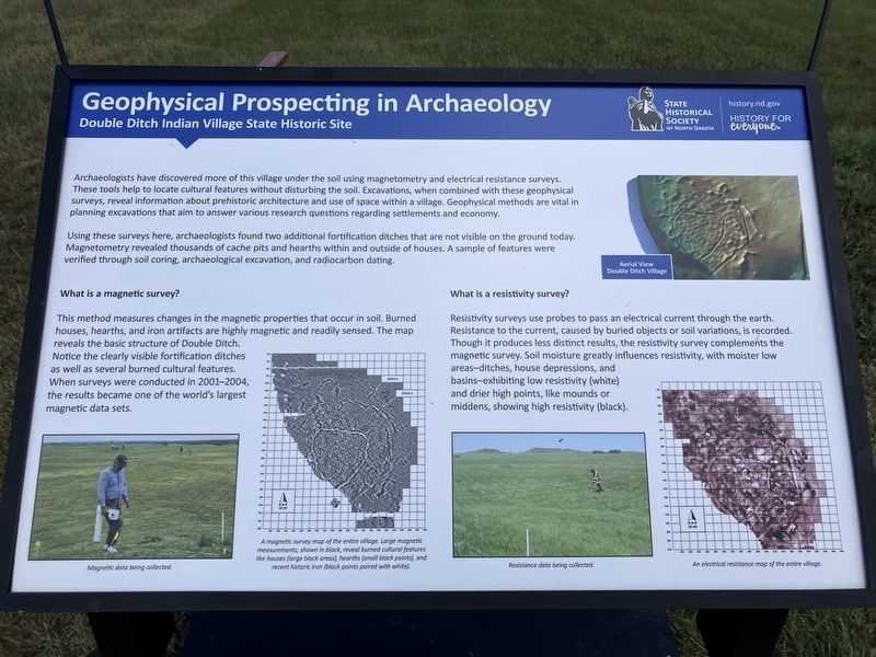
Captions: (upper aright) Aerial View Double Ditch Village.; (bottom row, left to right) Magnetic data being collected; A magnetic survey map of the entire village. Large magnetic measurements, shown in black, reveal burned cultural features like houses( (large black areas), hearths (small black points), and recent historic iron (black points paired with white).; Resistance data being collected.; An electrical resistance map of the entire village.
Using these surveys here, archaeologist found two additional fortification ditches the that are not visible on the ground today. Magnetometry revealed thousands of cache pits and hearths within and outside of houses. A sample of features were verified through soil coring, archaeological excavation, and radiocarbon dating.
What is a magnetic survey?
This method measures changes in the magnetic properties that occur in soil, Burned houses, hearths, and iron artifacts are highly magnetic and readily sensed. The map reveals the basic structure of Double Ditch. Notice the clearly visible fortification ditches as well as several burned cultural features.
this page online
What is a resistivity survey?
Resistivity surveys use probes to pass and electrical current through the earth. Resistance to the current, caused by buried objects or soil variations, is recorded. Though it produces less distinct results, the resistivity survey complements the magnetic survey. Soil moisture greatly influences resistivity, with moister low areas-ditches, house depressions, and basins-exhibiting low resistivity (white), and drier high points, like mounds or middens, showing high resistivity (black). Captions: (upper aright) Aerial View Double Ditch Village.; (bottom row, left to right) Magnetic data being collected; A magnetic survey map of the entire village. Large magnetic measurements, shown in black, reveal burned cultural features like houses( (large black areas), hearths (small black points), and recent historic iron (black points paired with white).; Resistance data being collected.; An electrical resistance map of the entire village.
Erected by State Historical Society of North Dakota.
Topics. This historical marker is listed in these topic lists: Anthropology & Archaeology • Indigenous Peoples and Communities.
Location. 46° 56.047′ N, 100° 53.894′ W. Marker is near Harmon, North Dakota, in Burleigh County. It can be reached from State Highway 1804 at milepost 91 near Double Ditch Loop. Harmon, North Dakota is on the opposite side of the Missouri River from Double Ditch Indian Village State Historic Site which is located in Burleigh County. Touch for map. Marker is in this post office area: Mandan ND 58554, United States of America. Touch for directions.

Regionally, this marker is on the Missouri Plateau and in Greater Bismarck Area. It is also in the American Lewis & Clark Corridor, on the prairies, and on the Northern Plains. Globally, it is in North America, the Western Hemisphere, the Western World, and the Anglosphere. Historically, it finds itself in what was once Rupert’s Land and also the Louisiana Purchase.
Other nearby markers. At least 8 other markers are within walking distance of this marker: A different marker also named Geophysical Prospecting in Archaeology (here, next to this marker); Early Maps Illustrating Double Ditch (within shouting distance of this marker); Missouri River Resources (within shouting distance of this marker); Ditch 2 (within shouting distance of this marker); Double Ditch State Historic Site (within shouting distance of this marker); Final Occupation of Double Ditch (about 300 feet away, measured in a direct line); Ditch 3 (about 400 feet away); Archaeological Excavations in 1905 (about 500 feet away).
More about this marker. This marker has replaced an earlier marker also listed on Historical Marker Database. The text is similar.
Credits. This page was last revised on September 14, 2025. It was originally submitted on September 14, 2025, by Barry Swackhamer of Brentwood, California. This page has been viewed 62 times since then and 17 times this year. Photo 1. submitted on September 14, 2025, by Barry Swackhamer of Brentwood, California.
