Niagara Falls in Niagara Region, Ontario — Central Canada (North America)
Millenium Recreational Trail
Photographed by Kevin Westell, September 17, 2025
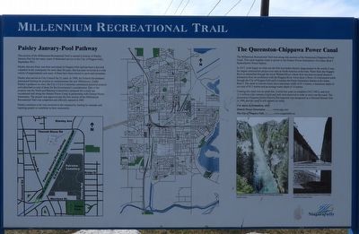
1. Millenium Recreational Trail - Marker
Paisley Janvary-Pool Pathway
This section of the Millennium Recreational Trail is named in honour of Paisley Janvary-Pool for her many years of dedicated service to the City of Niagara Falls, September 2011.
Paisley Janvary-Pool, was born and raised in Niagara Falls and has been a devoted volunteer in the community for more than 50 years. She has been involved in a wide variety of organizations and many of them have been related to sport and recreation.
Paisley also served on City Council for 21 years. In 1998, the Federal Government announced funding for projects to commemorate the new Millennium. Under Paisley's guidance as chair, the City's Civic Committee entertained potential projects and submitted several of them for the Government's consideration. One of the projects was the Trails and Bikeway Committee's proposal for a multi use recreational trail along the Ontario Power Canal in partnership with Ontario Power Generation. The project was approved and the first section of the Millennium Recreational Trail was completed and officially opened in 2001.
Paisley continues to
this page online
The Queenston-Chippawa Power Canal
The Millennium Recreational Trail runs along side sections of the Queenston-Chippawa Power Canal. This canal supplies water to power to the Ontario Power Generation's Sir Adam Beck I Hydroelectric Power Station.
In 1917, work began on what was the first true hydro-electric mega-project in the world. It was the largest construction project ever seen in North America at the time. Water from the Niagara River is channelled through the lower Welland River, whose flow has been reversed almost 6 kilometres from its confluence with the Niagara River. From there it flows 13.2 kilometres north through the City of Niagara Falls until it reaches the Pump Generation Station at Sir Adam Beck I. The canal is concrete lined, has a maximum width of 91.5 metres, a maximum depth of cut rock of 43.5 metres and an average water depth of 15 metres.
Creating this canal was no small feat. It took four years to complete (1917-1921), and over 11.5 million cubic metres of earth
Photographed by Kevin Westell, September 17, 2025
2. Millenium Recreational Trail - Marker in context
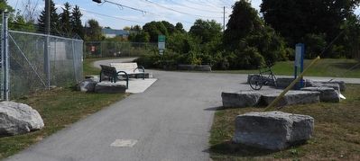
Photo faces south from Thorold Stone Road. The marker (right) is 10 metres from the road's sidewalk. The subject walking/biking path jinks to the left, then continues south out of sight.
For more information, visit:
Ontario Power Generation.....www.opg.com
The City of Niagara Falls.....www.niagarafalls.ca
Erected by City of Niagara Falls.
Topics. This historical marker is listed in these topic lists: Charity & Public Work • Industry & Commerce • Parks & Recreational Areas • Waterways & Vessels.
Location. 43° 6.918′ N, 79° 5.312′ W. Marker is in Niagara Falls, Ontario, in Niagara Region. It is at the intersection of Thorold Stone Road and Stanley Ave, on the right when traveling east on Thorold Stone Road. Touch for map. Marker is at or near this postal address: 5681 Thorold Stone Road, Niagara Falls ON L2J 1A1, Canada. Touch for directions.

Regionally, this marker is on the Golden Horseshoe and in Niagara Canada. It is also in Central Canada. Globally, it is in North America, on the Great Lakes, in the Western Hemisphere, in the Western World, and in the Anglosphere. Historically, it finds itself in what was once a British colony, the Viceroyalty of New France, the Haudenosaunee (Iroquois) Confederacy, and Rupert’s Land.
Other nearby markers. At least 8 other markers are within walking distance of this marker: Niagara Falls Park and River Railway (approx. 1.2 kilometers away); Niagara River Recreation Trail (approx. 1.2 kilometers away); Church of St. John the Evangelist (approx. 1.3 kilometers away); Buried Railway Trestle and Buried Gorge (approx. 1.3 kilometers away); Niagara Portage Road (approx. 1.4 kilometers away); Mitchell Cottage 1805 (approx. 1.4 kilometers away); Alexander Robinson Cody House circa 1821 (approx. 1.4 kilometers away); 3357 St Patrick 1805 (approx. 1.5 kilometers away). Touch for a list and map of all markers in Niagara Falls.
Credits. This page was last revised on September 19, 2025. It was originally submitted on September 18, 2025, by Kevin Westell of St. Catharines, Ontario. This page has been viewed 52 times since then and 17 times this year. Photos: 1, 2. submitted on September 18, 2025, by Kevin Westell of St. Catharines, Ontario. • Andrew Ruppenstein was the editor who published this page.
