Northport in Tuscaloosa County, Alabama — The American South (East South Central)
Northport's Cotton Industry ⎯⎯⎯ Original Village of North Port
Photographed by Jimmy Emerson
1. Northport's Cotton Industry Marker
Inscription.
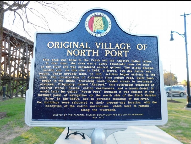
Northport's Cotton Industry, also, Original Village of North Port. . In 19th-century Northport, the land was fertile, cotton was king and the riverbank was a hub for commerce and activity. Warehouses were built for cotton storage as early as 1824 near this site along the banks of the Black Warrior River. The cotton, which had been transported along Byler Road, was loaded on to steamships bound for markets all over the world. The docks and boat landings were located on the river's margin where the water level was high enough to safely accommodate steamships. In 1897, when the M and O train trestle was built, the cotton warehouse was relocated to a parcel of land east of the trestle. A cotton gin was installed at the turn of the 20th century, to further expand the business of cotton. On March 21, 1932, a tornado destroyed the cotton warehouse and gin. They were rebuilt soon afterward, and remained operational until the 1970s. The gin structures were removed in 2006 to make way for future development of the riverfront., Reverse Side , This area was home to the Creek and the Choctaw Indian tribes. At that time, the area was a dense canebrake near the falls of the river and was considered neutral ground. The tribes became hostile and, on this site in 1785, a fierce, two-day battle was fought. Three decades later, in 1816, settlers began arriving to the area. The construction of Alabama's first public road, Byler Road, began in the 1820s, providing much-needed access to northwest Alabama. Originally named "Kentuck,” this settlement consisted of several stores, houses, cotton warehouses, and a tavern-hotel. It would later be called "North Port” because it was located at the farthest point of navigation on the north side of the Black Warrior River. In the 1830s, due to periodic flooding of the river, the buildings were relocated to their present-day location, with the exception of the cotton warehouses, which were to remain along the riverbank.
In 19th-century Northport, the land was fertile, cotton was king
and the riverbank was a hub for commerce and activity. Warehouses
were built for cotton storage as early as 1824 near this site along
the banks of the Black Warrior River. The cotton, which had been
transported along Byler Road, was loaded on to steamships bound
for markets all over the world. The docks and boat landings were
located on the river's margin where the water level was high enough
to safely accommodate steamships. In 1897, when the M & O train
trestle was built, the cotton warehouse was relocated to a parcel
of land east of the trestle. A cotton gin was installed at the turn
of the 20th century, to further expand the business of cotton. On
March 21, 1932, a tornado destroyed the cotton warehouse and gin.
They were rebuilt soon afterward, and remained operational until
the 1970s. The gin structures were removed in 2006 to make
way for future development of the riverfront.
Reverse Side
This area was home to the Creek and the Choctaw Indian tribes.
At that time, the area was a dense canebrake near the falls
of the river and was
Click or scan to see this page online
considered neutral ground. The tribes became
hostile and, on this site in 1785, a fierce, two-day battle was
fought. Three decades later, in 1816, settlers began arriving to the
area. The construction of Alabama's first public road, Byler Road,
began in the 1820s, providing much-needed access to northwest
Alabama. Originally named "Kentuck,” this settlement consisted of
several stores, houses, cotton warehouses, and a tavern-hotel. It
would later be called "North Port” because it was located at the
farthest point of navigation on the north side of the Black Warrior
River. In the 1830s, due to periodic flooding of the river,
the buildings were relocated to their present-day location, with the
exception of the cotton warehouses, which were to remain
along the riverbank.
Erected 2023 by Alabama Tourism Department and the City of Northport.
87° 34.636′ W. Marker is in Northport, Alabama, in Tuscaloosa County. It is at the intersection of Main Avenue and 1st Street, on the right when traveling south on Main Avenue. Touch for map. Marker is at or near this postal address: 106 Main Avenue, Northport AL 35476, United States of America. Touch for directions.
Regionally, this marker is in the American South and specifically in the Deep South. Globally, it is in North America, a Gulf of Mexico state, the Western Hemisphere, the Western World, and the Anglosphere. Historically, it finds itself in what was once the territory of the Mississippian Culture, one of the Confederate States of America, and the Antebellum South.
More about this marker. Marker was to have been erected in 2010 but was not installed as of August 2022 but was installed by Fall 2023 when I took this picture.
Credits. This page was last revised on September 30, 2025. It was originally submitted on September 27, 2025, by Jimmy Emerson of Dalton, Georgia. This page has been viewed 92 times since then and 41 times this year. Photos:1, 2. submitted on September 27, 2025, by Jimmy Emerson of Dalton, Georgia. • James Hulse was the editor who published this page.
Editor’s want-list for this marker. A wide view photo of the marker and the surrounding area together in context. • Can you help?