Cape May Point in Cape May County, New Jersey — The American Northeast (Mid-Atlantic)
A Beacon to Freedom
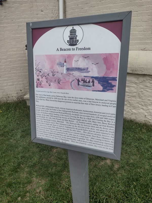
Photographed by Charles Berman, September 24, 2025
1. A Beacon to Freedom Marker
Due west of the beach, across Delaware Bay, were the slave states of Delaware, Maryland and Virginia. The lighthouse, erected in 1859 near the site of two earlier ones, was a true beacon to enslaved people across the bay. Many braved the currents to reach the free state of New Jersey, landing in Cape May.
William Still, a Philadelphia-based, African American abolitionist, businessman, historian and civil rights activist, often called the Father of the Underground Railroad, interviewed hundreds of escaped enslaved people. In his book, Underground Railroad Records, he details two accounts from 1858 and 1860 respectively, of freedom seekers landing at this beach: Crossing the Bay in a Skiff and Crossing the Bay in a Batteau. In the latter, Still detailed the bravery of Thomas Sipple and wife, Mary Ann, Henry Burkett and Elizabeth, his wife, John Purnell and Hale Burton -- six freedom seekers setting out from Kunkletown near Worcester County, Maryland. “The Delaware Bay lay between them and the Jersey shore, which the desired to reach. They managed to find out the direction of the shore, and about the length of time that it might take them to reach it. Undaunted by the perils before them the party repaired to the bay, and at ten o’clock P.M. embarked direct for the other shore… They did not calculate, however, that before leaving the Delaware shore they would have to contend with the enemy. Near Kate’s Hammock on the Delaware shore, they were attacked by five white men in a small boat.” After
this page online
Topics and series. This historical marker is listed in these topic lists: Abolition & Underground RR • African Americans • Waterways & Vessels. In addition, it is included in the Lighthouses series list. A significant historical year for this entry is 1859.
Location. 38° 55.982′ N, 74° 57.618′ W. Marker is in Cape May Point, New Jersey, in Cape May County. It is on Light House Avenue (County Route 629) north of Yale Avenue, on the left when traveling north. Located in Cape May Point State Park. Touch for map. Marker is at or near this postal address: 215 Light House Avenue, Cape May NJ 08204, United States of America. Touch for directions.

Regionally, this marker is on New Jersey’s Jersey Shore. It is also in the American Northeast, in the Mid-Atlantic, and on the Eastern Seaboard. Globally, it is in the North Atlantic Region, North America, the Western Hemisphere, the Western World, and the Anglosphere. Historically, it finds itself in what was once New Netherland and also one of the original Thirteen Colonies.
Other nearby markers. At least 8 other markers are within walking distance of this marker: Lighthouse Keepers' Homes & Gardens (here, next to this marker); Monomoy Lifesaving Boat (here, next to this marker); The Cape May Lighthouse (a few steps from this marker); Oil House (a few steps from this marker); a different marker also named Welcome to the Cape May Lighthouse (a few steps from this marker); Maritime Sentinels (a few steps from this marker); a different marker also named Oil House (a few steps from this marker but has been replaced with another marker now near it); A Woman Leads the Lighthouse (a few steps from this marker).
Other markers no longer nearby. Welcome to the Cape May Lighthouse (was a few steps from this marker but has been replaced with another marker now near it); All Shapes, Sizes and Materials (was a few steps from this marker but has been replaced with another marker now near it).
Credits. This page was last revised on October 4, 2025. It was originally submitted on September 30, 2025, by Charles Berman of Binghamton, New York. This page has been viewed 65 times since then and 22 times this year. Photo 1. submitted on September 30, 2025, by Charles Berman of Binghamton, New York. • Michael Herrick was the editor who published this page.
Editor’s want-list for this marker. A wide view photo of the marker and its surroundings. • Can you help?
