
Highland Park in Saint Paul in Ramsey County, Minnesota — The American Midwest (Upper Plains)
Crosby Farm
Photographed by McGhiever, August 23, 2025
1. Crosby Farm Marker
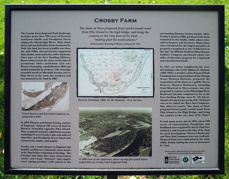
The chain of these proposed forest parks would reach from Pike Island to the high bridge, and bring the country to the very door of St. Paul… "making glad the waste places."
Minneapolis Morning Tribune, January 29, 1911
The Crosby Farm Regional Park landscape includes more than 700 acres of forested sandstone bluffs and floodplain forest edging the Mississippi River. Only about three and one-half miles from downtown St. Paul, the land has been in public use since the mid-1960s, but previously supported dairy farms, stone quarries, and a log boom. Once part of the Fort Snelling Military Reservation across the river, at the time of permanent white settlement this was Reserve Township, established in 1858 and settled primarily by farmers. The township extended north to Marshall Avenue and to Dale Street at the west; the southern end was annexed to St. Paul in 1887.
Forest Reserve and West End Commons as proposed in 1911.
In 1858 Thomas and Emma Crosby, natives of England, claimed 160 acres of land in Reserve Township opposite Pike Island. They acquired extensive additional acreage including 31-acre Crosby Lake
this page online
Crosby was a cattle farmer in England and briefly worked as a wholesale meat dealer in St. Paul before returning to farming. The Crosbys and their five sons raised dairy cattle and crops. Potatoes and apples were among produce well suited to the surrounding Ramsey County market. After Crosby's death in 1886, portions of the farm remained in the family, while others were sold to farmers and investors. Many ideas were circulated for this important piece of property recognized as the "wilderness in the city." In 1896 the Frederick Weyerhauser Lumber Company purchased about two miles of shoreline property for a log boom and unrealized sawmill.
Reserve Township, 1886 (G.M. Hopkins)
A 1940 view of the landscape, about twenty-five years before acquisition as Crosby Farm Regional Park.
In 1911, as urban neighborhoods were developing to the north, Alpheus B. Stickney (1840-1916), a member of the Board of Park Commissioners and president of the Chicago Great Western Railway, proposed the acquisition of the farm as a public Forest Reserve. Reserve

Photographed by McGhiever, August 23, 2025
2. Crosby Farm Marker at the south trailhead of the paved path through Crosby Farm Regional Park
It took many years, but in 1965, about 500 acres of surrounding floodplain and bluffland were acquired by the St. Paul Port Authority and leased to the City of St. Paul for park development. Reserve Boulevard and West End Commons were not realized. Shepard Road was constructed in the early 1960s, finally linking the area to downtown St. Paul.
Erected by Saint Paul Department of Parks and Recreation, Federal Highway Commission, Great River Road Minnesota, America's Byways.
Topics. This historical marker is listed in these topic lists: Agriculture • Parks & Recreational Areas. A significant historical year for this entry is 1858.
Location. 44° 53.887′ N, 93° 9.942′ W. Marker is in Saint Paul, Minnesota, in Ramsey County. It is in Highland Park. It is on Crosby Farm Road. The marker is in Crosby Farm Regional Park, at the beginning of the trail at the south parking lot. Touch for map. Marker is in this post office area: Saint Paul MN 55116, United States of America. Touch for directions.

Regionally, this marker is in the Twin Cities Metropolitan Area. It is also in the American Midwest, in the Corn Belt, and in the Great River Road Region. Globally, it is in North America, the Western Hemisphere, the Western World, and the Anglosphere. Historically, it finds itself in what was once Rupert’s Land, the territory of the Mississippian Culture, and the Louisiana Purchase.
Other nearby markers. At least 8 other markers are within walking distance of this marker: Floodplain Forests (about 400 feet away, measured in a direct line); Prairies (about 700 feet away); Explore Your Mississippi (approx. 0.2 miles away); Wetlands (approx. 0.2 miles away); The Lay of the Land (approx. 0.7 miles away); De Dakod Makoce Unkitawapi E E (approx. 0.7 miles away); Settling the Frontier (approx. 0.7 miles away); Two Rivers Overlook (approx. 0.7 miles away). Touch for a list and map of all markers in Saint Paul.
Credits. This page was last revised on October 2, 2025. It was originally submitted on October 2, 2025, by McGhiever of Minneapolis, Minnesota. This page has been viewed 96 times since then and 60 times this year. Photos: 1, 2. submitted on October 2, 2025, by McGhiever of Minneapolis, Minnesota.
