St. Michaels in Talbot County, Maryland — The American Northeast (Mid-Atlantic)
John Smith Shallop
Chesapeake Bay Maritime Museum
Photographed by Devry Becker Jones (CC0), October 5, 2025
1. John Smith Shallop Marker
Inscription.
John Smith Shallop. .
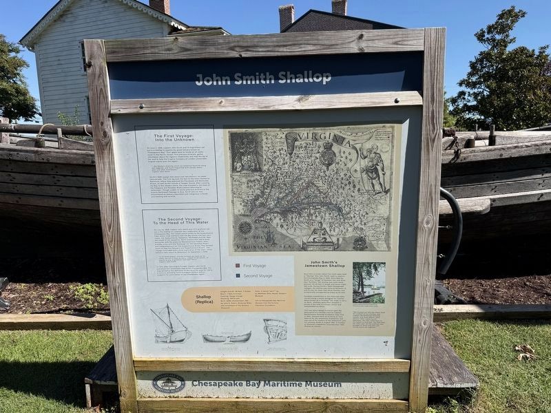
John Smith's Jamestown Shallop. Very little is known about the small open boat or "shallop" that John Smith used to explore the Chesapeake Bay in 1608. Described by Smith as a "barge" of between two and three tons of "burthen," the shallop was most likely between 25-35 feet in length and seven-eight feet wide. During Smith's 1608 Chesapeake voyages, the shallop was home to between 13 and 15 men for more than three months, and occasionally transported as many as 25 men., European expeditions to the Americas often carried along a vessel designed for coastal patrol known as a "shallop." Too large to carry on deck, shallops were often shipped in pieces in the hold of a larger vessel and reassembled on shore., This two-piece design is based upon the description of a shallop used by Captain Bartholomew Gosnald to explore Cape Cod in 1602. Gosnald went on to serve as Vice Admiral for the Jamestown Expedition and was one of the leaders of the settlement until his untimely death in August 1607. A member of Gosnold's expedition recorded their 1602 shallop as follows:,
"We hoisted out [of] the ship's hold the onehalf of our shallop, and Captain Bartholomew Gosnold, myself, and three others, went ashore." After exploring all afternoon, the men came back to the beach to find that, "by that time, the other part [of the shallop] was brought to shore and [the two halves were] set together."
The First Voyage: Into the Unknown. On June 2, 1608, Captain John Smith and 14 Englishmen set out in a shallop to explore the great estuary known as "Chesapeack Bay." Their goals were to locate an all-water route to the Pacific Ocean, find precious minerals, gather information about the region's inhabitants, and map the lay of the land to help the Virginia Company of London consolidate English claims over the region.,
" the Western shore by which we sailed we found all along well watered and much frequented with wolves, bears, deer and other wild beasts." Captain John Smith
Smith's 1608 voyage took place over two distinct, six-week time periods. The first leg took then men to the lower Delmarva Peninsula, where they explored the Pocomoke and Nanticoke Rivers, as well as the islands of Tangier Sound. After crossing the Bay to the western shore, the crew traveled to the head of the Patapsco and Potomac Rivers before returning to Jamestown. Though unable to locate precious minerals or the elusive Northwest Passage to Asia, Smith and his men encountered an estuary populated with indigenous cultures and teeming with wildlife.",
The Second Voyage: To the Head of This Water. On July 24, 1608, Captain John Smith and 12 Englishmen set out in the shallop to complete their exploration of the Chesapeake Bay. The vessel sailed swiftly to the Susquehanna Flats where crew members saw the Bay divide into four main rivers: the Susquehanna, Sassafras, Northeast and Elk. Near the mouth of the Sassafras, Sith and his men had a tense encounter with the powerful Massawomeck Indians. After friendly visits with the Tockwogh (on the Sassafras River) and Susquehannock (on the Susquehanna River), the headed south to map the Patuxent and Rappahannock Rivers. The voyage concluded with a brief exploration of the lower James before safe return to Jamestown on September 7, 1608.,
"In all those places and the furthest we came up the rivers, we cut in trees so many crosses as we would, to signify to any, Englishmen had been there." Captain John Smith
In 1612, after returning to Europe, Captain John Smith published this remarkable map of the Chesapeake Bay. The map served as the definitive rendering of the area for nearly a century, providing future European settlers with a blueprint for colonization of the Chesapeake region.,
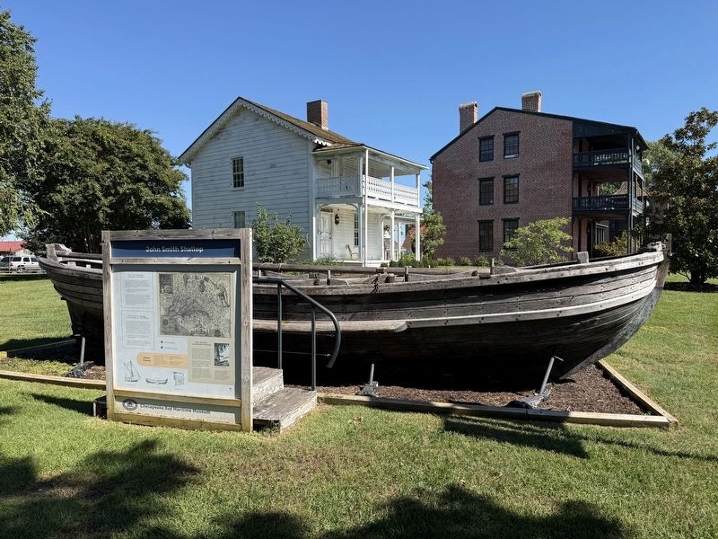
Shallop (Replica).
Length overall: 28 feet, 7 inches Beam: 7 feet, 8 inches Framing: Osage orange Planking: White oak Built: 2006, Chestertown, Md. by John E. Swain, Nicholas Biles, and volunteers of the Sultana Shiphard Sails: 2-sailed "sprit" rig, by Matthew Otto, Mystic Seaport Museum, Gift to the Chesapeake Bay Maritime Museum from the Sultana Education Foundation
John Smith's Jamestown Shallop
Very little is known about the small open boat or "shallop" that John Smith used to explore the Chesapeake Bay in 1608. Described by Smith as a "barge" of between two and three tons of "burthen," the shallop was most likely between 25-35 feet in length and seven-eight feet wide. During Smith's 1608 Chesapeake voyages, the shallop was home to between 13 and 15 men for more than three months, and occasionally transported as many as 25 men.
European expeditions to the Americas often carried along a vessel designed for coastal patrol known as a "shallop." Too large to carry on deck, shallops were often shipped in pieces in the hold of a larger vessel and reassembled on shore.
This two-piece design is based upon the description of a shallop used by Captain Bartholomew Gosnald to explore Cape Cod in 1602. Gosnald went on to serve as Vice Admiral for the Jamestown Expedition and was one of the leaders of the settlement until his untimely death in August 1607. A member of Gosnold's expedition recorded their 1602 shallop as follows:
"We hoisted out [of] the ship's hold the onehalf of our
Click or scan to see this page online
shallop, and Captain Bartholomew Gosnold, myself, and three others, went ashore." After exploring all afternoon, the men came back to the beach to find that, "by that time, the other part [of the shallop] was brought to shore and [the two halves were] set together."
The First Voyage:
Into the Unknown
On June 2, 1608, Captain John Smith and 14 Englishmen set out in a shallop to explore the great estuary known as "Chesapeack Bay." Their goals were to locate an all-water route to the Pacific Ocean, find precious minerals, gather information about the region's inhabitants, and map the lay of the land to help the Virginia Company of London consolidate English claims over the region.
" the Western shore by which we sailed we found all along well watered and much frequented with wolves, bears, deer and other wild beasts."
Captain John Smith
Smith's 1608 voyage took place over two distinct, six-week time periods. The first leg took then men to the lower Delmarva Peninsula, where they explored the Pocomoke and Nanticoke Rivers, as well as the islands of Tangier Sound. After crossing the Bay to the western shore, the crew traveled
Photographed by Devry Becker Jones (CC0), October 5, 2025
2. John Smith Shallop replica display
to the head of the Patapsco and Potomac Rivers before returning to Jamestown. Though unable to locate precious minerals or the elusive Northwest Passage to Asia, Smith and his men encountered an estuary populated with indigenous cultures and teeming with wildlife."
The Second Voyage:
To the Head of This Water
On July 24, 1608, Captain John Smith and 12 Englishmen set out in the shallop to complete their exploration of the Chesapeake Bay. The vessel sailed swiftly to the Susquehanna Flats where crew members saw the Bay divide into four main rivers: the Susquehanna, Sassafras, Northeast and Elk. Near the mouth of the Sassafras, Sith and his men had a tense encounter with the powerful Massawomeck Indians. After friendly visits with the Tockwogh (on the Sassafras River) and Susquehannock (on the Susquehanna River), the headed south to map the Patuxent and Rappahannock Rivers. The voyage concluded with a brief exploration of the lower James before safe return to Jamestown on September 7, 1608.
"In all those places and the furthest we came up the rivers, we cut in trees so many crosses as we would, to signify to any, Englishmen had been there."
Captain John Smith
In 1612, after returning to Europe, Captain John Smith published this remarkable map of the Chesapeake Bay. The map served as the definitive rendering of the area for nearly a century, providing future European settlers with a blueprint for colonization of the Chesapeake region.
Shallop
(Replica)
Length overall: 28 feet, 7 inches Beam: 7 feet, 8 inches Framing: Osage orange Planking: White oak Built: 2006, Chestertown, Md. by John E. Swain, Nicholas Biles, and volunteers of the Sultana Shiphard Sails: 2-sailed "sprit" rig, by Matthew Otto, Mystic Seaport Museum
Gift to the Chesapeake Bay Maritime Museum from the Sultana Education Foundation
Location. 38° 47.234′ N, 76° 13.278′ W. Marker is in St. Michaels, Maryland, in Talbot County. It can be reached from Mill Street west of Burns Street, on the left when traveling west. Touch for map. Marker is at or near this postal address: 302 Mill St, Saint Michaels MD 21663, United States of America. Touch for directions.

Regionally, this marker is on the Eastern Shore. It is also in the American Mid-Atlantic, on the Delmarva Peninsula, in the Tidewater, and in the Chesapeake Bay Region. Globally, it is in the North Atlantic Region, North America, the Western Hemisphere, the Western World, and the Anglosphere. Historically, it finds itself in what was once one of the original Thirteen Colonies and also the Antebellum South.
Other markers no longer nearby. Shallop (was a few steps from this marker but has been replaced with another marker now near it); Captain John Smith's Shallop (was a few steps from this marker but has been permanently removed); Navy Point Historic Houses (was within shouting distance of this marker but has been permanently removed); Freedom's Figurehead (was within shouting distance of this marker but has been permanently removed); What's under your feet? (was within shouting distance of this marker but has been replaced with another marker now near it).
Credits. This page was last revised on October 6, 2025. It was originally submitted on October 6, 2025, by Devry Becker Jones of Washington, District of Columbia. This page has been viewed 63 times since then and 18 times this year. Photos:1, 2. submitted on October 6, 2025, by Devry Becker Jones of Washington, District of Columbia.