Saxis in Accomack County, Virginia — The American South (Mid-Atlantic)
Saxis Island Culture

In 1666, Robert Sikes, the island's namesake, was granted land here. Until the 1750s, Saxis Island was used for raising livestock tended initially by local Indians. Settlers then arrived from nearby Maryland and Virginia. By 1870, all men inhabiting the island were oystermen. In the 1880s there was an oyster boom. By 1920, the island's population had grown to over 600. Today, there are less than 200 people living on the island.
Relying on the natural bounty of the Chesapeake Bay and surrounding marshes, people adapted year to year and season to season to the changing bounty – from oysters, to clams, to crabs, to fish, to trapping, and back to oysters. The island's inhabitants have survived hurricanes, nor-easters and winters when the Pocomoke Sound was frozen solid.
The offshore Steamboat Wharf, built in 1903, was destroyed by the Storm of 1933. In 1936, the Creek Point Wharf was built, and the channel was dredged in 1937. In 1954, Hurricane Hazel sank most of the boats in the harbor. In the 1960s, the new Harbor of Refuge was built. Crab shedding houses were built on Creek Point and near the new harbor. The were
this page online
Over 150 years later, a few remaining watermen continue crabbing, oystering and fishing. In some years the natural oyster rocks near the island are open, and oystering thrives. In other years, they are closed and the island's oystermen travel to the James and Rappahannock Rivers to work.
Learn more about the history and life of Saxis, and enjoy a taste of the trading lifestyle of the Saxis Island watermen. Visit the Crockett Store, the only surviving general store in Saxis, and now home to the Saxis Island Museum.
Topics. This historical marker is listed in these topic lists: Colonial Era • Industry & Commerce • Settlements & Settlers • Waterways & Vessels. A significant historical year for this entry is 1666.
Location. 37° 55.168′ N, 75° 43.653′ W. Marker is in Saxis, Virginia, in Accomack County. It is on Starling Creek Road south of Saxis Road, on the left when traveling east. Touch for map. Marker is at or near this postal address: 9137 Starling Crk Rd, Saxis VA 23427, United States of America. Touch for directions.

Regionally, this

Photographed by Devry Becker Jones (CC0), October 11, 2025
2. Several markers in front of the comfort station at the docks
Other nearby markers. At least 8 other markers are within 8 miles of this marker, measured as the crow flies: While Visiting (here, next to this marker); Severn J. Crockett General Store (approx. 0.3 miles away); This Memorial Pyramid (approx. 5.1 miles away); Francis Makemie Monument (approx. 5.1 miles away); Anne Makemie Holden (approx. 5.2 miles away); Makemie Monument Park (approx. 5.2 miles away); Make Peace (approx. 6.8 miles away in Maryland); Ward Brothers Workshop (approx. 7.3 miles away in Maryland). Touch for a list and map of all markers in Saxis.
Photographed by Devry Becker Jones (CC0), October 11, 2025
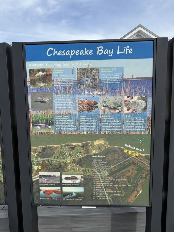
3. Chesapeake Bay Life
This adjacent sign features no historical information but shares details on local wildlife as well as a legend for the map on both signs.
Credits. This page was last revised on October 12, 2025. It was originally submitted on October 12, 2025, by Devry Becker Jones of Washington, District of Columbia. This page has been viewed 68 times since then and 32 times this year. Photos: 1, 2, 3. submitted on October 12, 2025, by Devry Becker Jones of Washington, District of Columbia.
