Bouckville in Madison County, New York — The American Northeast (Mid-Atlantic)
Welcome to the Chenango Canal Towpath Trail

Photographed by Paige Miller, September 7, 2025
1. Welcome to the Chenango Canal Towpath Trail Marker
Welcome to the Chenango Canal Towpath Trail
Chenango Canal Association, Inc. Mission
The Chenango Canal Association (CCA) is dedicated to preserving, maintaining and improving the historic Chenango Canal and its towpath. Preservation of the canal creates an understanding of its historic significance, as well as builds a foundation for ongoing, positive community development. This is accomplished through a range of recreational and educational activities.
The Cottage Museum is located on the corner of Canal Road & Scenic Byway State Rt. 20, Bouckville. Open 10-5, it contains a collection of local history and explains the impact the Chenango Canal had on New York State and America from 1837-1878. Adjacent parking is available.
The CCA meets every month and is an all-volunteer organization. We partner with local schools and colleges to keep the trail clear and rely on the generosity of local businesses. Our budget is based on donations, friend's memberships, fundraisers and grants to keep the Towpath Trail along the 5-mile summit clear for the public to enjoy. Please sign in our visitor's book and consider a donation.
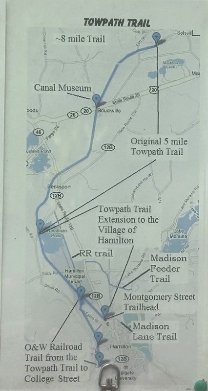
Towpath Trail
The
this page online
The length of the trail from Hamilton to the North end is about 8 miles. There is a Hamilton Police shooting range next to the trail near Woodman Pond. Watch for signs warning when the range is in use. Trespassing signs are for Woodman Pond and not for use of the trail.
There is an about 1.5 mile branch along the abandoned O&W railroad bed leading south from the Hamilton Municipal Airport to College Street. The RR trail also goes north from the airport to Woodman Road and a 1 K walk along the road to the west leads to the Towpath trail back to the airport. Park at the airport and one can circumnavigate the airport.
Park at the Chenango Canal Association Cottage Museum in Bouckville at the intersection of Canal Road and Route 20. Open for self-guiding 10 AM to 5 PM. There is a self-guided audio tour of the Trail in Bouckville for smart phones.
--- or park at The North

Photographed by Paige Miller, September 7, 2025
2. Chenango Canal Towpath Trail
showing stairway down from street level to the canal towpath
-- or park at
---Woodman Pond Road at the canal
---or park at the Montgomery Street Trailhead.
Birding along the trail is excellent at peak migration times and Woodman Pond often has a wide variety of waterfowl in the Fall. There are geocaching locations along the Trail. For more information see www.chenangoCanal.org.
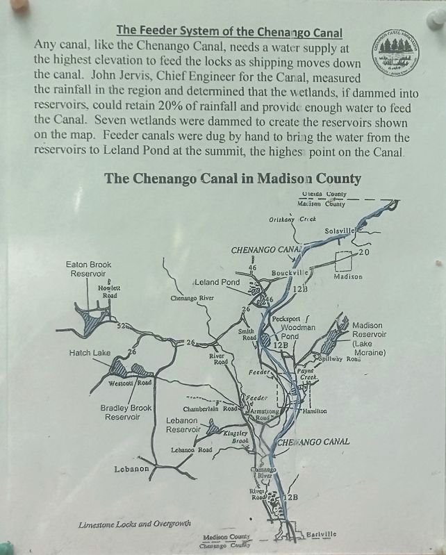
The Feeder System of the Chenango Canal
Any canal, like the Chenango Canal, needs a water supply at the highest elevation to feed the locks as shipping moves down the canal. John Jervis, Chief Engineer for the Canal, measured the rainfall in the region and determined that the wetlands, if dammed into reservoirs, could retain 20% of rainfall and provide enough water to feed The Canal. Seven wetlands were dammed to create the reservoirs shown on the map. Feeder canals were dug by hand to bring the water from the reservoirs to Leland Pond at the summit, the highest point on the Canal.
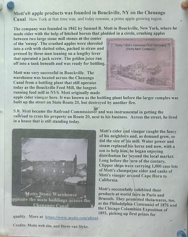
Mott's® apple products was founded in Bouckville, NY on the Chenango Canal. New York at that time was, and today remains, a prime apple growing region.
The company was founded in

Photographed by Paige Miller, September 7, 2025
3. Chenango Canal Towpath Trail
Mott was very successful in Bouckville. The warehouse was located across the Chenango Canal from a bottling plant that still operates today as the Bouckville Feed Mill, the longest-running feed mill in NYS. Mott originally made apple cider vinegar here. It was known as the bottling plant before the larger complex was built up the street on State Route 20, but destroyed by another fire.
S.R. Mott became the Railroad Commissioner and was instrumental in getting the railroad to cross his property on Route 20, next to his business. Across the street, he lived in a house that is still standing today.
Mott's cider and vinegar caught the fancy of his neighbors and, as demand grew, so did the size of his mill. Water power and steam replaced his horse and now, with a son to help him, he began enjoying distribution far beyond the local market. Long before the turn of the century, Clipper ships were carrying 1,000 case lots of Mott's champagne cider and casks of Mott's vinegar around Cape Horn to California.
Mott's Stone Warehouse opposite the main buildings across the Chenango Canal Mott's successfully exhibited their products at world fairs in Paris and Brussels. They promoted their wares, too, at the Philadelphia Centennial of 1876 and the Chicago Columbian Exposition of 1893, picking up first prizes for quality. More at https://www.motts.com/about.
Credits: Motts web site, and

Photographed by Paige Miller, September 7, 2025
4. Bouckville Feed Mill
Mentioned in the marker text
Erected by Chenango Canal Association.
Topics. This historical marker is listed in these topic lists: Agriculture • Industry & Commerce • Waterways & Vessels. A significant historical year for this entry is 1837.
Location. 42° 53.269′ N, 75° 33.135′ W. Marker is in Bouckville, New York, in Madison County. It is on Canal Road (County Route 81) 0.1 miles south of US Route 20 (U.S. 20), on the right when traveling south. Touch for map. Marker is at or near this postal address: 3448 Canal Road, Bouckville NY 13310, United States of America. Touch for directions.

Regionally, this marker is in Upstate New York, specifically in Central New York, and in the Syracuse Metropolitan Area. It is also in the American Northeast and in the Mid-Atlantic. Globally, it is in North America, the Western Hemisphere, the Western World, and the Anglosphere. Historically, it finds itself in what was once the Haudenosaunee (Iroquois) Confederacy, New Netherland, and one of the original Thirteen Colonies.
Other nearby markers. At least 8 other markers are within 4 miles of this marker, measured as the crow flies:
Photographed by Susan A. Dalaba, June 26, 2026
5. Welcome to the Chenango Canal Towpath Trail Marker
Photographed by Susan A. Dalaba, June 26, 2026
6. Welcome to the Chenango Canal Towpath Trail Marker
Photographed by Susan A. Dalaba, June 26, 2026
7. Welcome to the Chenango Canal Towpath Trail Marker
Credits. This page was last revised on July 11, 2026. It was originally submitted on October 23, 2025, by Paige Miller of Getzville, New York. This page has been viewed 119 times since then and 57 times this year. Photos: 1, 2, 3, 4. submitted on October 23, 2025, by Paige Miller of Getzville, New York. 5, 6, 7. submitted on June 27, 2026, by Susan A. Dalaba of Cortland, New York. • Andrew Ruppenstein was the editor who published this page.
