Solomons in Calvert County, Maryland — The American Northeast (Mid-Atlantic)
Majestic Patuxent River
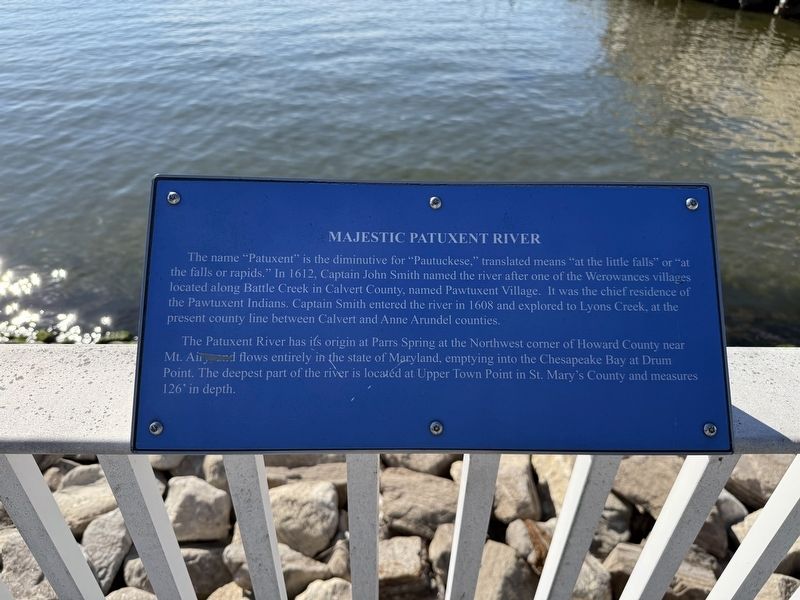
The name "Patuxent" is the diminutive for "Pautuckese," translated means "at the little falls" or "at the falls or rapids." In 1612, Captain John Smith named the river after one of the Werowances villages located along Battle Creek in Calvert County, named Pawtuxent Village. It was the chief residence of the Pawtuxent Indians. Captain Smith entered the river in 1608 and explored to Lyons Creek, at the present county line between Calvert and Anne Arundel counties.
The Patuxent River has its origin at Parrs Spring at the Northwest corner of Howard County near Mt. Airy and flows entirely in the state of Maryland, emptying into the Chesapeake Bay at Drum Point. The deepest part of the river is located at Upper Town Point in St. Mary's County and measured 126' in depth.
Topics. This historical marker is listed in these topic lists: Exploration • Indigenous Peoples and Communities • Settlements & Settlers • Waterways & Vessels. A significant historical year for this entry is 1612.
Location. 38° 19.249′ N, 76° 27.511′ W. Marker is in Solomons, Maryland, in Calvert County. It is on Solomons Island Road South north
this page online

Regionally, this marker is in Southern Maryland. It is also in the American South, specifically in the Upper South, in the Mid-Atlantic, in the Tidewater, in the Chesapeake Bay Region, and on the Eastern Seaboard. Globally, it is in the North Atlantic Region, North America, the Western Hemisphere, the Western World, and the Anglosphere. Historically, it finds itself in what was once one of the original Thirteen Colonies and also the Antebellum South.
Other nearby markers. At least 8 other markers are within walking distance of this marker: The ESSO Fleet (within shouting distance of this marker); Dewey Floating Dry Dock (within shouting distance of this marker); Point Patience (within shouting distance of this marker); Patuxent River Naval Air Station (about 300 feet away, measured in a direct line); Governor Thomas Johnson Bridge (about 600 feet away); M. M. Davis Shipyard (about 700 feet away); Watery Grave (about 700
Credits. This page was last revised on November 2, 2025. It was originally submitted on November 2, 2025, by Devry Becker Jones of Washington, District of Columbia. This page has been viewed 80 times since then and 38 times this year. Photos: 1, 2. submitted on November 2, 2025, by Devry Becker Jones of Washington, District of Columbia.
