Marlboro in Ulster County, New York — The American Northeast (Mid-Atlantic)
Presbyterian Church & Cemetery
Photographed by Clifton Patrick, March 10, 2010
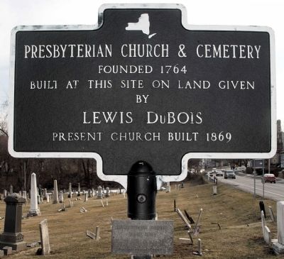
1. Presbyterian Church & Cemetery Marker
Founded 1764 Built at this site on land given by Louis DuBois Present church built in 1869
[Plaque:]
Revolutionary soldiers buried here.
Erected by N. Y. State Organization NSDAR.
Topics and series. This historical marker is listed in these topic lists: Cemeteries & Burial Sites • Colonial Era • Heroes • Military • Patriots & Patriotism • Religion & Religious Structures • War, US Revolutionary. In addition, it is included in the Daughters of the American Revolution (DAR) series list. A significant historical year for this entry is 1764.
Location. 41° 36.168′ N, 73° 58.335′ W. Marker is in Marlboro, New York, in Ulster County. It is on U.S. 9W (U.S. 9W) 0.2 miles County Road 14 (County Route 14), on the left when traveling south. Touch for map. Marker is at or near this postal address: 1340 U.S 9W, Marlboro NY 12542, United States of America. Touch for directions.

Regionally, this marker is in Upstate New York and in the Hudson Valley. It is also in the American Northeast, in the Mid-Atlantic, and on the Eastern Seaboard. Globally, it is in the North Atlantic Region, North
this page online
Other nearby markers. At least 8 other markers are within 4 miles of this marker, measured as the crow flies: Gomez Mill House (approx. 1.2 miles away); Estate Owned and Occupied 1804-1812 By George Clinton (approx. 2.3 miles away); Historic Carnwath Farms (approx. 2½ miles away); Carnwath Farms (approx. 2.6 miles away); Mesier Park (approx. 2.8 miles away); a different marker also named Mesier Park (approx. 2.9 miles away); Old Indian Road (approx. 3 miles away); War Memorial (approx. 4 miles away).
Photographed by Clifton Patrick, March 10, 2010
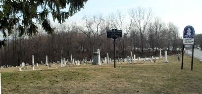
2. Presbyterian Church & Cemetery (looking south).
Credits. This page was last revised on March 10, 2022. It was originally submitted on March 15, 2010, by Clifton Patrick of Chester, NY, United States. This page has been viewed 1,598 times since then and 58 times this year. Last updated on March 18, 2010, by Clifton Patrick of Chester, NY, United States. Photos: 1, 2. submitted on March 15, 2010, by Clifton Patrick of Chester, NY, United States. • Bill Pfingsten was the editor who published this page.
