Chester in Chesterfield County, Virginia — The American South (Mid-Atlantic)
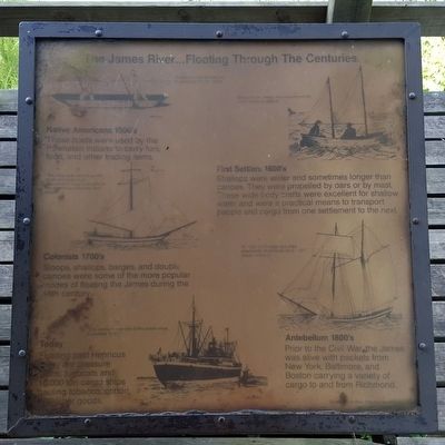
The James River...Floating Through The Centuries
Photographed by Bernard Fisher, August 29, 2015
1. The James River...Floating Through The Centuries Marker
Native Americans 1500's
These boats were used by the Powhatan Indians to carry furs, food, and other trading items.
First Settlers 1600's
Shallops were wider and sometimes longer than canoes. They were propelled by oars or by mast. These wide body crafts were excellent for shallow water and were a practical means to transport people and cargo from one settlement to the next.
Colonists 1700's
Sloops, shallops, barges, and double canoes were some of the more popular modes of floating the James during the 18th century.
Antebellum 1800's
Prior to the Civil War, the James was alive wth packets from New York, Baltimore, and Boston carrying a variety of cargo to and from Richmond.
Today
Floating past Henricus today are pleasure crafts, tugboats and 10,000 ton cargo ships hauling tobacco, cotton, and other goods.
[Captions:]
"Rough canoes, burned and scraped out of virgin timber"
"Boats on the James were versions of the Indian canoe or shallop"
"The River was swarming with boats and ships of all descriptions, many built right on the plantation from their own forests" "in 1855 1,217 boats and ships entered the (Richmond) dock,1,377 departed from it"
"The James is now one of the state's more accessible rivers"
Quotes from In River Time Ann Woodlief, 1985
Topics.
this page online
Location. Marker has been permanently removed. It was located near 37° 22.597′ N, 77° 21.629′ W. Marker was in Chester, Virginia, in Chesterfield County. It could be reached from Henricus Park Road 1.3 miles east of Coxendale Road, on the left when traveling east. Located in Henricus Historical Park 300 yards north of the parking lot. Touch for map. Marker was at or near this postal address: 251 Henricus Park Road, Chester VA 23836, United States of America.
We have been informed that this marker is no longer there and will not be replaced. This page is an archival view of what was.
Regionally, this marker was in the Piedmont, in Central Virginia, and in the Richmond Metropolitan Area. It was also in the American South, specifically in the Upper South, and on the Eastern Seaboard. Globally, it was in the North Atlantic Region, North America, the Western Hemisphere, the Western World, and the Anglosphere.

Photographed by Bernard Fisher, August 29, 2015
2. The James River...Floating Through The Centuries Marker
Other nearby markers. At least 8 other markers are within walking distance of this location: Mortar Pit (a few steps from this marker); USCTs At Dutch Gap (a few steps from this marker); Dutch Gap Canal (a few steps from this marker); The Bermuda Hundred Campaign (a few steps from this marker); The Lightkeeper’s House (within shouting distance of this marker); Henricopolis (within shouting distance of this marker); The Church of Henricopolis (within shouting distance of this marker); Henricus Historical Park (within shouting distance of this marker). Touch for a list and map of all markers in Chester.
Other markers no longer nearby. Dutch Gap (was here, next to this marker but has been permanently removed); The Tides (was here, next to this marker but has been permanently removed); Mount Malady (was here, next to this marker but has been permanently removed).
Also see . . . Henricus Historical Park. (Submitted on August 30, 2015.)
Photographed by Bernard Fisher, August 29, 2015
3. The James River...Floating Through The Centuries Marker
Credits. This page was last revised on November 10, 2025. It was originally submitted on August 30, 2015, by Bernard Fisher of Richmond, Virginia. This page has been viewed 664 times since then and 30 times this year. Last updated on November 8, 2025, by Evan Dwyer of Richmond, Virginia. Photos: 1, 2, 3. submitted on August 30, 2015, by Bernard Fisher of Richmond, Virginia. • Devry Becker Jones was the editor who published this page.
