Chester in Chesterfield County, Virginia — The American South (Mid-Atlantic)
Dutch Gap Conservation Area
Captain John Smith’s Adventures on the James
| — | www.johnsmithtrail.org | — |
Photographed by Bernard Fisher, August 23, 2015
1. Dutch Gap Conservation Area Marker
Chesterfield County Parks & Recreation website entry
Click for more information.
Click for more information.
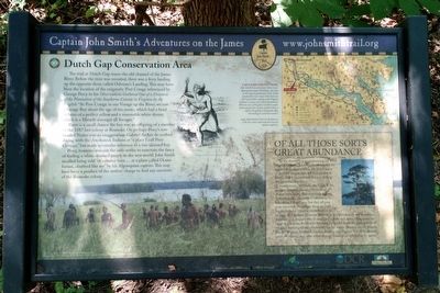
The trail at Dutch Gap traces the old channel of the James River. Before the river was rerouted, there was a ferry landing on the opposite shore called Osborne’s Landing. This may have been the location of the enigmatic Port Cotage referenced by George Percy in his Observations Gathered Out of a Discourse of the Plantation of the Southerne Colonie of Virginia by the English: “At Port Cotage in our Voyage up the River, we saw Savage Boy about the age of ten yeeres, which had a head of haire of a perfect yellow and a reasonable white skinne, which is a Miracle amongst all Savages.”
There is a small chance the boy was an offspring of a member of the 1587 lost colony at Roanoke. Or, perhaps Percy’s tow-headed Native was an exaggeration. Gabriel Archer described dining with the Arrohateck Indians at “a place I call Poor Cottage,” but made no similar reference to a fair-skinned boy.
Percy, however, was not the only settler to entertain the fancy of finding a white-skinned people in the new world. John Smith recalled being told "of a certaine men…at a place called Ocanahonan, cloathed like me” by his Algonquian captors.
this page online
Capt. John Smith’s Trail
John Smith knew the James River by its Algonquian name: Powhatan, the same as the region’s paramount chief. Smith traveled the river many times between 1607 and 1609, trading with Virginia Indians to ensure survival at Jamestown. What he saw of Virginia’s verdant woodlands and pristine waters inspired him to explore the greater Chesapeake Bay, chronicling its natural wonders.
Capt. John Smith’s Trail on the James is a 40-site water trail and auto tour for modern explorers.
(sidebar)
Of All Those Sorts Great Abundance
In the description accompanying his 1612 Map of Virginia, John Smith catalogued the region's abundant wildlife. He listed many of the bird species that still find shelter at Dutch Gap Conservation Area, including the great blue heron.
Smith wrote: "Of birds, the Eagle is the greatest devourer. Hawkes there be of diverse sorts as our Falconers called them, Sparrowhawkes, Lanarets, Goshawkes, Falcons and Osperayes; but they all pray most upon fish. Partridges there are little bigger
Photographed by Bernard Fisher, August 23, 2015
2. Dutch Gap Conservation Area Marker
Erected by Captain John Smith's Trail. (Marker Number 10.)
Topics. This historical marker is listed in these topic lists: Colonial Era • Exploration • Indigenous Peoples and Communities • Settlements & Settlers. A significant historical year for this entry is 1587.
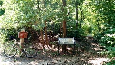
Location. 37° 21.934′ N, 77° 23.387′ W. Marker is in Chester, Virginia, in Chesterfield County. It can be reached from Henricus Park Road 1.3 miles east of Coxendale Road. Located on the Dutch Gap Trail in the Dutch Gap Conservation Area. Touch for map. Marker is at or near this postal address: 251 Henricus Park Road, Chester VA 23836, United States of America. Touch for directions.

Regionally, this marker is in the Piedmont, in Central Virginia, and in the Richmond Metropolitan Area. It is also in the American South, specifically in the Upper South, and on the Eastern Seaboard. Globally, it is in the North Atlantic Region, North America, the Western Hemisphere, the Western World, and the Anglosphere. Historically, it finds itself in what was once the territory of the Mississippian Culture, one of the original Thirteen Colonies, one of the Confederate States of America, and the Antebellum South.
Other nearby markers. At least 8 other markers are within walking distance of this marker: The Battle of Trent’s Reach (approx. 0.4 miles away); Battery Dantzler (approx. half a mile away); The Bermuda Hundred Campaign (approx. half a mile away); a different marker also named Battery Dantzler (approx. half a mile away); Olin Miller Dantzler (approx. half a mile away); a different marker also named Battery Dantzler (approx. half a mile away); The Siege of Petersburg (approx. 0.9 miles away); a different marker also named Battery Dantzler (approx. 0.9 miles away). Touch for a list and map of all markers in Chester.
More about this marker. On the lower left is a depiction of Native Americans along the James River. The photo carries the caption "“The New World” © MMV, New Line Productions, Inc. All rights reserved. Photo by Merie Wallace. Photo appears courtesy of New Line Productions, Inc."
On the upper center is a sketch of a "tow-headed Native" Image Courtesy of the Library of Virginia
Also see . . . Captain John Smith Chesapeake National Historic Trai-l3,000 Miles...15,000 Years of Culture. National Park Service website entry (Submitted on April 5, 2023, by Larry Gertner of New York, New York.)
Credits. This page was last revised on November 10, 2025. It was originally submitted on August 23, 2015, by Bernard Fisher of Richmond, Virginia. This page has been viewed 943 times since then and 52 times this year. Last updated on November 8, 2025, by Evan Dwyer of Richmond, Virginia. Photos: 1, 2. submitted on August 23, 2015, by Bernard Fisher of Richmond, Virginia. • Devry Becker Jones was the editor who published this page.
