Arvada in Jefferson County, Colorado — The American Mountains (Southwest)
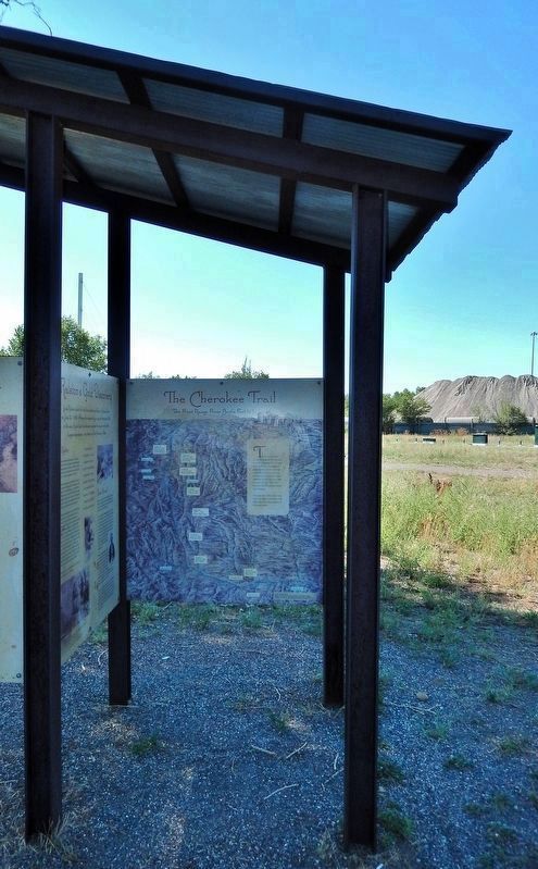
The Cherokee Trail
The Front Range from Bent's Fort to Laramie

Photographed by Cosmos Mariner, August 14, 2022
1. The Cherokee Trail Marker
The route followed by the McNair party of 1850 has been named the Cherokee Trail, in honor of the members of the Cherokee tribes and their families who were among the first to travel the area. Sections of the trail may have been established by early fur traders, thus the name “Trappers Trail”. The Cherokee Trail extends from Bent’s Fort to Laramie.
This map, dated 1894, shows many towns and settlements not yet established when the trail was pioneered in the mid-1800s.
[campsites highlighted on map, from south to north]
Camp 34 — June 10, 1850 — Bent’s Fort
Camp 37 — June 13, 1850 — Fort Pueblo
Camp 38 — June 15, 1850 — Fountain River
Camp 40 — June 17, 1850 — “Passed Pike’s Peak”
Camp 41 — June 18, 1850 — Cherry Creek
Camp 42 — June 19, 1850 — “Waters of the Platt”
Camp 43 — June 20, 1850 — crossed the South Platte River
Camp 44 — June 22, 1850 — Lewis Ralston’s Gold Discovery [here at this site!]
[map legend]
Courtesy US Geological Survey Reproduced from the original map held in the collection of the Library of Congress, Geography and Map Division. Map originally drawn by Frank Pezolt, copyrighted by The Caxton Co. in 1894 and published by James McConnell School Supplies, Denver, CO.
Topics.
this page online
Location. 39° 47.88′ N, 105° 3.391′ W. Marker is in Arvada, Colorado, in Jefferson County. It can be reached from West 56th Avenue just south of Ralston Road, on the right when traveling east. The marker is on the south side of an interpretive kiosk in Gold Strike Park. Touch for map. Marker is at or near this postal address: 5500 West 56th Avenue, Arvada CO 80002, United States of America. Touch for directions.

Regionally, this marker is in the Front Range. It is also in the American Mountain West. Globally, it is in North America, the Rocky Mountains, the Western Hemisphere, the Western World, and the Anglosphere. Historically, it finds itself in what was once the Louisiana Purchase.
Other nearby markers. At least 8 other markers are within 2 miles of this marker, measured as the crow flies: Placer Mining (here, next to this marker); Ralston's Gold Discovery (here, next to this marker); Gold Fever (here, next to this marker); Gold Was Discovered
Photographed by Cosmos Mariner, August 14, 2022
2. The Cherokee Trail Marker
The marker is on the south side of this interpretive kiosk in Gold Strike Park.
Related markers. Click here for a list of markers that are related to this marker.
Also see . . .
1. Cherokee Trail (Wikipedia).
Excerpt: The Cherokee Trail was a historic overland trail through the present-day U.S. states of Oklahoma, Kansas, Colorado, and Wyoming that was used from the late 1840s up through the early 1890s. The route was established in 1849 by a wagon train headed to the gold fields in California. Among the members of the expedition were a group of Cherokee.(Submitted on November 29, 2025, by Cosmos Mariner of Cape Canaveral, Florida.)
According to Erb, Brown, and Hughes, "The Cherokee Trail came west out of Oklahoma along the Arkansas River Valley in Colorado to the mouth of Black Squirrel Creek, a tributary of Cherry Creek (Colorado), following the latter to the South Platte River. It went on north along the eastern base of the Rockies to the Cache la Poudre in the vicinity of Laporte and Virginia Dale then over to the Laramie Plains.
2. History of the Cherokee Trail.
Excerpt: Captain Lewis Evans/Cherokee wagon company, joined by other wagons from Santa Fe, proceeded from Pueblo north along the front range of the Rocky Mountains on the old Trappers or Divide Trail. This trail, from Santa Fe to Fort Laramie, ran east of Colorado Springs, over “the divide” between the Arkansas and South Platte rivers watersheds, then north down Cherry Creek to the South Platte River, where Denver now stands. Clement Vann McNair's train stopped north of present Denver, spending two days panning gold on a small creek. Cherokee diarist John Lowery Brown noted the finding of gold on a creek they named Ralston for the discover.(Submitted on November 29, 2025, by Cosmos Mariner of Cape Canaveral, Florida.)
Credits. This page was last revised on November 29, 2025. It was originally submitted on November 28, 2025, by Cosmos Mariner of Cape Canaveral, Florida. This page has been viewed 90 times since then and 38 times this year. Photos: 1, 2. submitted on November 28, 2025, by Cosmos Mariner of Cape Canaveral, Florida.
