Arvada in Jefferson County, Colorado — The American Mountains (Southwest)
Gold Fever
1828 to 1858
Photographed by Cosmos Mariner, August 14, 2022
1. Gold Fever Marker
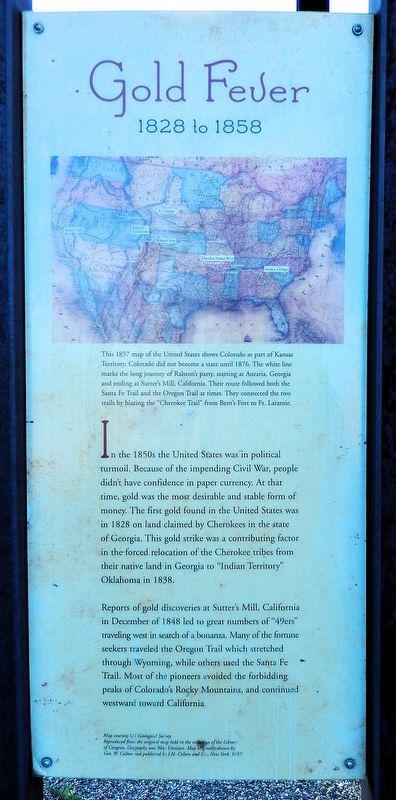
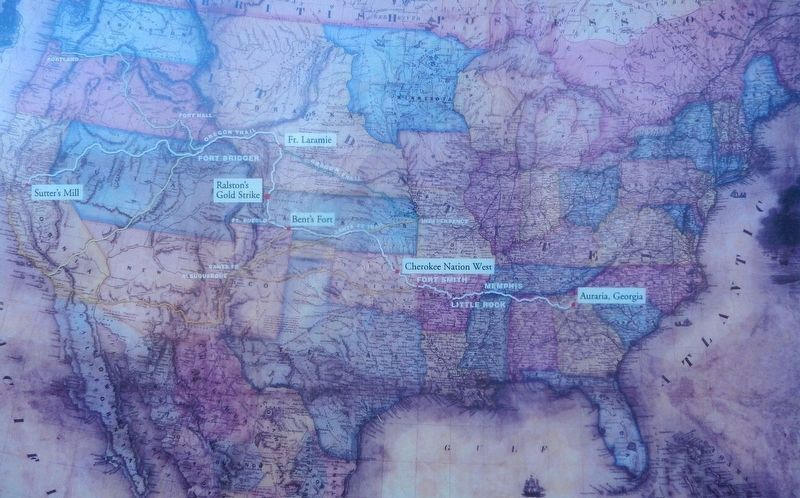
This 1857 map of the United States shows Colorado as part of Kansas Territory. Colorado did not become a state until 1876. The white line marks the long journey of Ralston's party, starting at Auraria, Georgia and ending at Sutter's Mill, California. Their route followed both the Santa Fe Trail and the Oregon Trail at times. They connected the two trails by blazing the “Cherokee Trail” from Bent's Fort to Ft. Laramie.
In the 1850s the United States was in political turmoil. Because of the impending Civil War, people didn't have confidence in paper currency. At that time, gold was the most desirable and stable form of money. The first gold found in the United States was in 1828 on land claimed by Cherokees in the state of Georgia. This gold strike was a contributing factor in the forced relocation of the Cherokee tribes from their native land in Georgia to “Indian Territory” Oklahoma in 1838.
Reports of gold discoveries at Sutter's Mill, California in December of 1848 led to great numbers of “49ers” traveling west in search of a bonanza. Many of the fortune seekers traveled the Oregon Trail which stretched through Wyoming, while others used the Santa Fe Trail. Most of the pioneers avoided the forbidding peaks of Colorado's Rocky Mountains and continued westward toward California.
Topics. This historical marker is listed in these topic lists: Exploration • Indigenous Peoples and Communities • Industry & Commerce • Roads & Vehicles. A significant historical year for this entry is 1828.
Location. 39° 47.882′ N, 105° 3.39′ W. Marker is in Arvada, Colorado, in Jefferson County. It can be reached from West 56th Avenue just south of Ralston Road, on the right when traveling east. The marker is on the north side of an interpretive kiosk in Gold Strike Park. Touch for map. Marker is at or near this postal
this page online

Regionally, this marker is in the Front Range. It is also in the American Mountain West. Globally, it is in North America, the Rocky Mountains, the Western Hemisphere, the Western World, and the Anglosphere. Historically, it finds itself in what was once the Louisiana Purchase.
Other nearby markers. At least 8 other markers are within 2 miles of this marker, measured as the crow flies: Ralston's Gold Discovery (here, next to this marker); Placer Mining (here, next to this marker); The Cherokee Trail (here, next to this marker); Gold Was Discovered (approx. ¾ mile away); McIlvoy House (approx. 1.2 miles away); Arvada's Trolleys (approx. 1.2 miles away); Arvada's First Park (approx. 1.2 miles away); Roads and Trains (approx. 1.2 miles away). Touch for a list and map of all markers in Arvada.
Related markers. Click here for a list of markers that are related to this marker.
Also see . . . Lewis Ralston (Wikipedia).
Excerpt: On January 24, 1848, James W. Marshall found placer gold near Coloma, California,(Submitted on November 29, 2025, by Cosmos Mariner of Cape Canaveral, Florida.)and unbeknownst nine days later, Mexico ceded California and the rest of northern Mexico to the United States with the Treaty of Guadalupe Hidalgo. The California Gold Rush ensued. In the spring of 1850, Lewis Ralston, an American placer gold prospector from Georgia, joined a wagon train of predominately Cherokee gold prospectors led by John Beck headed to the California gold fields. The party followed the Trail of Tears west, and on June 22, 1850, they crossed the South Platte River (a few miles north of what is today Denver) and camped near the confluence of two streams. Ralston panned for gold near the mouth of the smaller stream (in what is today Arvada.) He found about ¼ troy ounce of gold, then worth about five dollars (about $550 USD today.) While Ralston was elated, the rest of the party was unimpressed and continued on to California the next morning. Ralston continued panning for gold but gave up after a few days and caught up with his party. Ralston had little success in California and soon returned to his family in Georgia where he settled near Dahlonega.Courtesy US Geological Survey2. Marker detail: 1857 Map of the United StatesReproduced from the original map held in the collection of the Library of Congress, Geography and Map Division. Map originally drawn by Geo. W. Colton and published by J.H. Colton and Co., New York, 1857.

Photographed by Cosmos Mariner, August 14, 2022
3. Gold Fever Marker
The marker [left] is on the north side of this interpretive kiosk in Gold Strike Park.
Credits. This page was last revised on November 29, 2025. It was originally submitted on November 29, 2025, by Cosmos Mariner of Cape Canaveral, Florida. This page has been viewed 62 times since then and 22 times this year. Photos: 1, 2, 3. submitted on November 29, 2025, by Cosmos Mariner of Cape Canaveral, Florida.
