Leadville in Lake County, Colorado — The American Mountains (Southwest)
Welcome to Historic Leadville — Twin Lakes
⎯⎯⎯
Bienvenido a la histórico Leadville — Twin Lakes
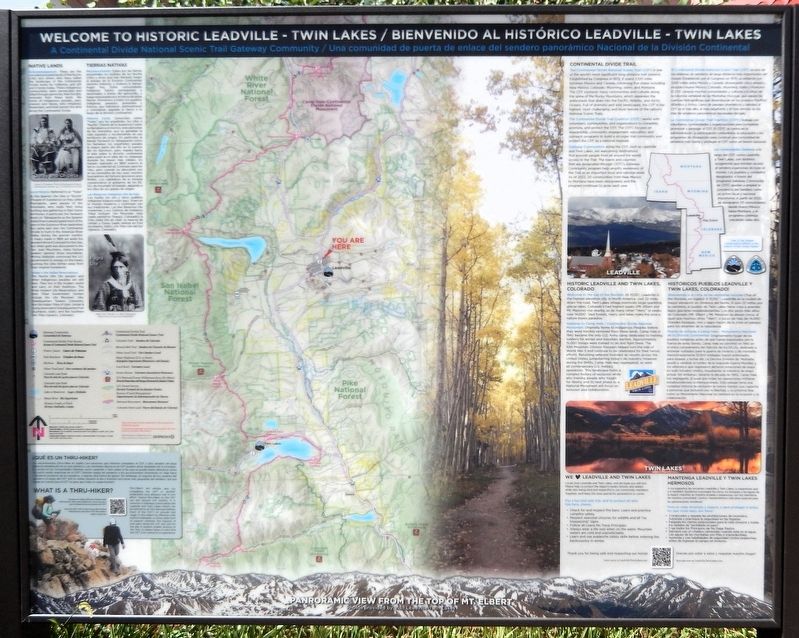
Photographed by Cosmos Mariner, July 27, 2025
1. Welcome to Historic Leadville — Twin Lakes / Bienvenido a la histórico Leadville — Twin Lakes Marker

Native Lands
Acknowledgement:
These are the unceded ancestral lands of the Nuche (Ute) and others who have called the landscape of the Continental Divide home for millennia, and still call it home today. These Indigenous communities were persecuted and killed through genocide, then forcibly removed from these lands. We honor all Indigenous peoples, past, present and future, who inhabited, stewarded, and hold sacred the land along the Continental Divide.
Local History:
Referred to as "Yutas" by the Spanish, the Utes or "Nuche" (People of Substance) as they called themselves, were people of the mountains who made their living hunting and gathering in their home territories. In particular, the Taviwach band (or Tabeguache as the Spanish called them) would spend most of the year in the Gunnison River watershed but came east over the Continental Divide to hunt in the Arkansas River Valley during the warmer months. A treaty made in 1868 set aside the western third of Colorado for the Utes, but when gold was discovered in the San Juan Mountains, many fortune
this page online
Today's Ute Indian Reservations:
The Nuche (the Ute people) and other Indigenous peoples are still here. They live in the modern world and carry on their traditions. The three modern Ute Reservations and their Tribal Government Centers include the Ute Mountain Utes (headquarters Towaoc, Colorado); the Ute Indian Tribe of Utah, Uintah & Ouray reservation (headquarters Fort Duchesne, Utah); and the Southern Ute Tribe (Ignacio, Colorado).
Continental Divide Trail
The Continental Divide National Scenic Trail (CDT) is one of the world's most significant long-distance trail systems. Established by Congress in 1978, it spans 3,100 miles between Mexico and Canada, traversing five states including New Mexico, Colorado, Wyoming, Idaho, and Montana. The CDT connects many communities and cultures along the spine of the Rocky Mountains, which separates the watersheds that drain into the Pacific, Atlantic, and Arctic Oceans. Full of dramatic and wild landscapes, the CDT is the highest,
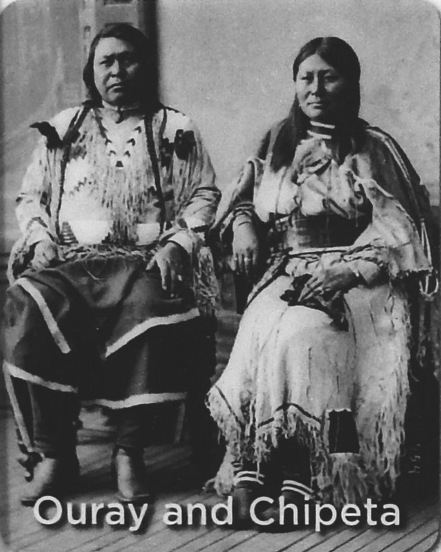
Library of Congress, Prints & Photographs Division
2. Marker detail: Ouray and Chipeta
The Continental Divide Trail Coalition (CDTC) works with volunteers, communities, and organizations to complete, promote, and protect the CDT. The CDTC focuses on stewardship, community engagement, education, and outreach programs to build a stronger trail community and protect the CDT as a national treasure.
Gateway Communities along the CDT, such as Leadville and Twin Lakes, are welcoming destinations that provide people from all around the world access to the Trail. The towns and counties that are designated through CDTC's Gateway Community program help amplify awareness of the Trail as an important local and national asset. As of 2022, 20 communities from New Mexico to Montana have been designated, and the program continues to grow each year.
Historic Leadville and Twin Lakes, Colorado
Welcome to the top of the Rockies!
At 10,152', Leadville is the highest-elevation city in North America. Just 22 miles down the road, Twin Lakes village overlooks large sparkling glacial lakes. Colorado's two highest peaks (Mt. Elbert and Mt. Massive) rise nearby, as do many other

Courtesy www.loc.gov/item/95500540
3. Marker detail: Pagre, Ute, ca. 1902
Gateway to Camp Hale - Continental Divide National Monument
Originally home to Indigenous Peoples before they were forcibly removed from these lands, Camp Hale in 1942 became the only U.S. Army camp dedicated to training soldiers for winter and mountain warfare. Approximately 15,000 troops were trained to ski and fight there. The 10th Mountain Division troopers helped turn the tide of World War II and continue to be celebrated for their heroic efforts. Returning veterans founded ski resorts across the United States, jumpstarting today's ski industry. However, during the 1940s, Camp Hale was segregated, as were all contemporary U.S. military operations. This landscape holds a complex history of exclusion while also training people who fought for liberty, and its next phase as a National Monument will focus on inclusion and collaboration.
We Love Leadville and Twin Lakes
Locals love Leadville and Twin Lakes, and we hope you will too! Please help us protect the region's peaks, forests, and waters while also being kind and respectful to
Photographed by Cosmos Mariner, July 27, 2025
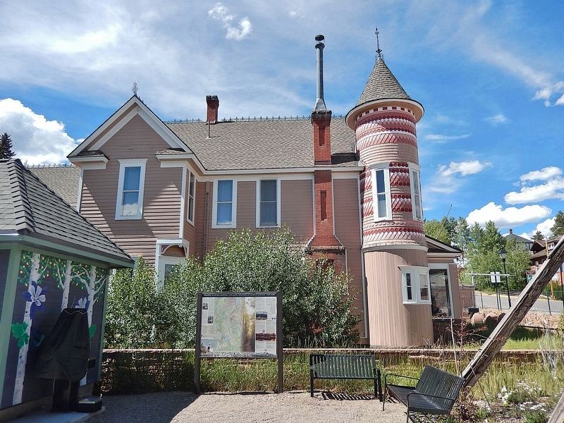
4. Welcome to Historic Leadville — Twin Lakes / Bienvenido a la histórico Leadville — Twin Lakes Marker
Looking north; there is an elaborate pink Victorian house behind the marker. Harrison Avenue is to the right of this photo.
For a fun and safe trip, and to protect all who live here, please:
• Check for and respect fire bans. Learn and practice campfire safety.
• Respect seasonal closures for wildlife and all "no trespassing" signs.
• Follow all Leave No Trace Principles.
• Always wear a life vest when on the water. Mountain waters are cold and unpredictable.
• Learn and use avalanche safety skills before entering the backcountry in winter.
Tierras Nativas
Reconocimiento:
Estas son las tierras ancestrales no cedidas de los Nuche (Ute) y otros que han llamado hogar al paisaje de la División Continental durante milenios, y todavía lo llaman hogar hoy. Estas comunidades indígenas fueron perseguidas y asesinadas a través del genocidio, y luego expulsadas por la fuerza de estas tierras. Honramos a todos los pueblos indígenas, pasados, presentes y futuros, que habitaron, administraron y consideran sagrada la tierra a lo largo de la división continental.
Historia Local:
Conocidos como "Yutas" por los españoles, los Utes o "Nuche" (Gente de la Sustancia) como se llamaban a sí mismos, eran personas de las montañas que se ganaban la vida cazando y recolectando en sus territorios de origen. En particular, la banda Taviwach (o Tabeguache como los llamaban los españoles) pasaba la mayor parte del año en la cuenca del río Gunnison, pero viajaba hacia el este sobre la división continental para cazar en el valle del río Arkansas durante los meses más cálidos. Un tratado realizado en 1868 reservó el tercio occidental de Colorado para los Utes, pero cuando se descubrió oro en las montañas de San Juan, muchos buscadores de fortuna ignoraron esos límites. Los cabilderos de la minería convencieron al gobierno de los EE. UU. de incumplir el tratado, alejando a los Utes de sus países de origen.
Las Reservas Indígenas Ute de hoy:
Los nuche, los Ute y otros pueblos indígenas todavía están aquí. Viven en el mundo moderno y continúan con sus tradiciones. Las tres Reservas Ute modernas y sus Centros de Gobierno Tribal incluyen Ute Mountain Utes (sede central en Towaoc, Colorado); la tribu india Ute de Utah, la reserva de Uintah y Ouray (sede central en Fort Duchesne, Utah); y la Tribu Ute del Sur (Ignacio, Colorado).
Continental Divide Trail
El Continental Divide National Scenic Trail (CDT) es uno de los sistemas de senderos de larga distancia más importantes del mundo Establecido por el Congreso en 1978, se extiende por 3,100 millas entre México y Canadá, atravesando cinco estados, incluidos Nuevo México, Colorado, Wyoming, Idaho y Montana. El CDT conecta muchas comunidades y culturas a lo largo de la columna vertebral de las Montañas Rocosas, que separa las cuencas hidrográficas que desembocan en los océanos Pacífico, Atlántico y Ártico. Lleno de paisajes dramáticos y salvajes, el CDT es el más alto, el más desafiante y el más remoto de los más de senderos panorámicos nacionales del país.
La Continental Divide Trail Coalition (CDTC) trabaja con voluntarios, comunidades y organizaciones para completar, promover y proteger el CDT. El CDTC se centra en la administración, la participación comunitaria, la educación y los programas de divulgación para construir una comunidad de senderos más fuerte y proteger el CDT como un tesoro nacional.
Las comunidades Gateway a lo largo del CDT, como Leadville y Twin Lakes, son destinos acogedores que brindan acceso al sendero a personas de todo el mundo. Los pueblos y condados designados a través del programa Gateway Community de CDTC ayudan a ampliar la conciencia del Sendero como un activo local y nacional importante. A partir de 2022, se designaron 20 comunidades desde Nuevo México hasta Montana, y el programa continúa creciendo cada año.
Históricos Pueblos Leadville y Twin Lakes, Colorado!
¡Bienvenido a la cima de las montañas rocosas (Top of the Rockies, en inglés)!
A 10,152 ', Leadville es la ciudad de mayor elevación en América del Norte. A solo 22 millas por la carretera, el pueblo de Twin Lakes tiene vista a grandes lagos glaciares resplandecientes. Los dos picos más altos de Colorado (Mt. Elbert y Mt. Massive) se elevan cerca, al igual que muchos otros "14ers", o picos de más de 14,000'. Grandes bosques, ríos y lagos hacen de la zona un paraíso para los amantes de la naturaleza.
Puerta de entrada a Camp Hale - Monumento Nacional de la División Continental:
Originalmente hogar de los pueblos indígenas antes de que fueran expulsados por la fuerza de estas tierras. Camp Hale se convirtió en 1942 en el único campamento del Ejército de los EE.UU. dedicado a entrenar soldados para la guerra de invierno y de montaña. Aproximadamente 15,000 soldados fueron entrenados para esquiar y luchar allí. La Décima División de Montaña ayudó a cambiar el rumbo de la Segunda Guerra Mundial, y los veteranos que regresaron abrieron estaciones de esquí en todo Estados Unidos, impulsando la industria de esquí actual. Sin embargo, durante la década de 1940, Camp Hale fue segregado, al igual que todas las operaciones militares estadounidenses contemporáneas. Este paisaje tiene una compleja historia de exclusión al mismo tiempo que capacita a personas que lucharon por la libertad. y su próxima fase como un Monumento Nacional se centrará en la inclusión y la colaboración.
Mantenga Leadville y Twin Lakes Hermosos
A los lugareños les encantan Leadville y Twin Lakes, y esperamos que a ti también! Ayúdenos a proteger los picos. los bosques y las aguas de la región mientras se muestra amable y respetuoso con los miembros de nuestra comunidad. Juntos, mantendremos esta área especial para las generaciones venideras! Para un viaje divertido y seguro, y para proteger a todos lo que viven aquí, por favor:
• Compruebe y respete las prohibiciones de incendios. Aprenda y practique la seguridad en las fogatas.
• Respete los cierres estacionales para la vida silvestre y todas las señales de "prohibido el paso".
• Siga todos los Principios de No Dejar Rastro.
• Siempre use un chaleco salvavidas cuando esté en el agua. Las aguas de las montañas son frías y impredecibles.
• Aprenda y use habilidades de seguridad contra avalanchas antes de ingresar al campo en invierno.
Topics. This historical marker is listed in these topic lists: Indigenous Peoples and Communities • Parks & Recreational Areas • Settlements & Settlers • War, World II.
Location. 39° 15.045′ N, 106° 17.576′ W. Marker is in Leadville, Colorado, in Lake County. It is on Harrison Avenue (U.S. 24) just south of West 9th Street, on the right when traveling south. Touch for map. Marker is at or near this postal address: 809 Harrison Avenue, Leadville CO 80461, United States of America. Touch for directions.

Regionally, this marker is in Colorado’s Arkansas River Valley, in the Colorado High Rockies and on the Continental Divide. It is also in the American Mountain West. Globally, it is in North America, the Rocky Mountains, the Western Hemisphere, the Western World, and the Anglosphere.
Other nearby markers. At least 8 other markers are within walking distance of this marker: Historic Mining Country (a few steps from this marker); Sounding the Alarm (a few steps from this marker); Leadville City Hall (within shouting distance of this marker); Side-Dumping Ore Car (within shouting distance of this marker); Carnegie Library (within shouting distance of this marker); Gravity Stamp Mill (about 300 feet away, measured in a direct line); Shaker Concentrating Table (about 300 feet away); Crib (about 300 feet away). Touch for a list and map of all markers in Leadville.
More about this marker. The marker stands perpendicular to Harrison Avenue, facing the small parking lot on the south side of the elaborate pink Victorian house.
Credits. This page was last revised on December 11, 2025. It was originally submitted on December 10, 2025, by Cosmos Mariner of Cape Canaveral, Florida. This page has been viewed 74 times since then and 34 times this year. Photos: 1, 2, 3, 4. submitted on December 11, 2025, by Cosmos Mariner of Cape Canaveral, Florida.
