Fort Walsh in Maple Creek No. 111, Saskatchewan — The Prairie Region (North America)
Cypress Hills Massacre National Historic Site
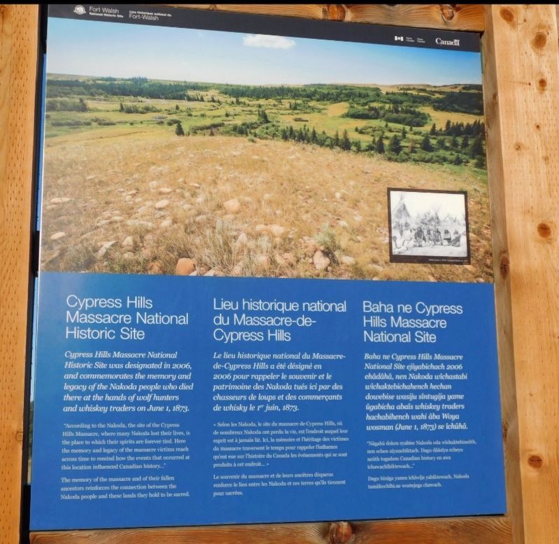
Photographed by Jimmy Emerson, September 30, 2024
1. Cypress Hills Massacre National Historic Site Marker

Cypress Hills Massacre National Historic Site
Cypress Hills Massacre National Historic Site was designated in 2006, and commemorates the memory and legacy of the Nakoda people who died there at the hands of wolf hunters and whiskey traders on June 1, 1873.
"According to the Nakoda, the site of the Cypress Hills Massacre, where many Nakoda lost their lives, is the place to which their spirits are forever tied. Here the memory and legacy of the massacre victims reach across time to remind how the events that occurred at this location influenced Canadian history…"
The memory of the massacre and of their fallen ancestors reinforces the connection between the Nakoda people and these lands they hold to be sacred.
Le lieu historique national du Massacre-de-Cypress Hills a été désigné en 2006 pour rappeler le souvenir et le patrimoine des Nakoda tués ici par des chasseurs de loups et des commerçants de whisky le r" juin, 1873.
« Selom les Nakoda, le she du massacre de Cypress Hills, de nombreux Nakeda ont pende la vie, est l'endroit auquel lur espritest à jamais lé, lei, la mémoire et Théritage des victimes do massacre traversent le temps pour rappeler The quisat eue sur l'histoire du Canada les événements qui se s produits à cet endroit… »
Click or scan to see
this page online
Le souvenir du massere et de leurs ancêtres disparas renfonce le lien entre les Naloda et ces terres qu'ils tiennent pour sacrées
Baha ne Cypress Hills Massacre National Site ejiyabichach 2006 ehadaha, nen Nakoda wichastabi wichaktebichahench hechan dowebise wasiju sintugija yame igabicha abais whiskey traders hachabihench wahi aba Woya wosman (June 1, 1873) se ichiha.
"Nigahi delen evabe Nalds isla wichinih nechen alamehiktach. Dags disyn echeys ith tagadam Canadian history en ava Ichawachibiwach…"
Dag hiniga yann ichiwa yabildewach, Nalds tamilochibine wotej chwach
Erected by Parks Canada.
Topics. This historical marker is listed in these topic lists: Indigenous Peoples and Communities • Industry & Commerce • Parks & Recreational Areas. A significant historical date for this entry is June 1, 1873.
Location. 49° 34.415′ N, 109° 52.811′ W. Marker is in Fort Walsh, Saskatchewan, in Maple Creek No. 111. It is on Saskatchewan Route 271 west of Highway 615, on the right when traveling west. The marker is located at the Fort Walsh National Historic Site Visitors Center. Touch for map. Marker is in this post office area: Fort Walsh SK S0N 0P0, Canada. Touch for directions.

Regionally, this marker is in Southwest Saskatchewan. It is also in the Prairies. Globally, it is in North America, the Western Hemisphere, the Western World, and the Anglosphere. Historically, it finds itself in what was once a British colony and also Rupert’s Land.
Other nearby markers. At least one other marker is within walking distance of this marker: James Morrow Walsh (within shouting distance of this marker).
Credits. This page was last revised on December 11, 2025. It was originally submitted on December 10, 2025, by Jimmy Emerson of Dalton, Georgia. This page has been viewed 78 times since then and 41 times this year. Photo 1. submitted on December 10, 2025, by Jimmy Emerson of Dalton, Georgia. • Devry Becker Jones was the editor who published this page.
