Near St. Francisville in Clark County, Missouri — The American Midwest (Upper Plains)
Archeology
Photographed by Connor Olson, October 17, 2025
1. Archeology Marker
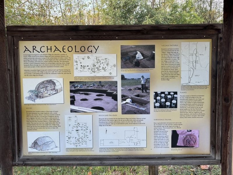
Archaeological investigations at the Iliniwek Village are critical for a number of reasons. While several known Illinois villages have been excavated, Iliniwek is the earliest and provides information unique to the earliest phases of culture contact. The assemblage from Iliniwek solidifies for archaeologists just what a seventeenth century Illinois assemblage, particularly the ceramics industry, looks like. This information provides a critical comparative baseline for archaeologists exploring culture change among the Illinois through time in the historic period and variation in the ways in which native peoples of other ethnicities responded to European contact.
Subsurface excavations began in 1993 and continued until 1998. Remote sensing was conducted in sections of the village in 1995 and in 1998. Since 1998, excavations have been sporadic. A fascinating picture of what the community looked like, and what life was like in the village has emerged.
Houses
Excavations have revealed evidence of four kinds of houses. The most substantial was a large longhouse with a central ridgeline. One of these (House 1) has been
this page online
Ditch and Palisade
Marquette did not mention the fact that Iliniwek Village was fortified. However, at least some portion of the western edge of the site was fortified with a ditch and palisade. Excavations have revealed a ditch about 5 meters (16.3 feet) wide with a loosely constructed palisade, made up of small diameter posts, erected adjacent to and on the village side of the ditch.
Village Pattern
Resistivity and hand excavation have demonstrated that the two "hilltop" villages that make up the Iliniwek Village State Historic Site are a long, linear settlement, stretching along the terrace edge for

Photographed by Connor Olson, October 17, 2025
2. Archeology Marker
Plants
The plant remains at Iliniwek are dominated by corn. A large percentage of all of the identified plant remains are corn. Beans and squash are present but in small numbers. There is also evidence of native domesticates including little barley, sunflower, knotweed and goosefoot. Watermelon, an Old World domesticate, is also present on the site and spread rapidly over the New World after introduction. Collected native species include American lotus, wild rice, raspberry, wild cherry, hawthorn, wild strawberry, persimmon, wild bean, hackberry and grape. Nuts include hickory, black walnut, hazelnut and acorns.
Subsistence Fauna
Bone is generally fairly well preserved in pits on the site. An analysis of 30 pits and their contents

Photographed by Connor Olson, October 17, 2025
3. Partially reconstructed Longhouse
Erected by Missouri Department of Natural Resources.
Topics. This historical marker is listed in these topic lists: Anthropology & Archaeology • Indigenous Peoples and Communities • Settlements & Settlers. A significant historical year for this entry is 1993.
Location. 40° 25.739′ N, 91° 33.453′ W. Marker is near St. Francisville, Missouri, in Clark County. It can be reached from County Road 188 north of County Road 200, on the right when traveling north. Touch for map. Marker is at or near this postal address: 22569 County Rd 188, Wayland MO 63472, United States of America. Touch for directions.

Regionally, this marker is in North Missouri. It is also in the American Lewis & Clark Corridor, in the Corn Belt, and in the Great River Road Region. Globally, it is in North America, the Western Hemisphere, the Western World, and the Anglosphere. Historically, it finds itself in what was once the territory of the Mississippian Culture, the Louisiana Purchase, and the Antebellum South.
Other nearby markers. At least 8 other markers are within 8 miles of this marker, measured as the crow flies: Daily Village Life (here, next to this marker); Iliniwek Village State Historic Site (here, next to this marker); Marquette and Joliet (here, next to this marker); Origins, Groups, and Encounters (here, next to this marker); The Illinois in History (here, next to this marker); The Longhouse (approx. 0.2 miles away); Fort Edwards (approx. 7.8 miles away in Illinois); Fort Edwards Monument (approx. 7.8 miles away in Illinois). Touch for a list and map of all markers in St. Francisville.
Credits. This page was last revised on December 28, 2025. It was originally submitted on December 27, 2025, by Connor Olson of Menomonee Falls, Wisconsin. This page has been viewed 71 times since then and 42 times this year. Photos: 1, 2, 3. submitted on December 27, 2025, by Connor Olson of Menomonee Falls, Wisconsin. • Devry Becker Jones was the editor who published this page.
