
Madison Mills in Madison County, Virginia — The American South (Mid-Atlantic)
Knights of the Golden Horseshoe
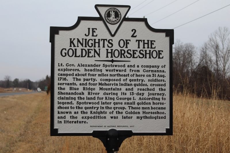
Photographed by Evan Dwyer, January 6, 2026
1. Knights of the Golden Horseshoe Marker
Erected 2017 by Virginia Department of Historic Resources. (Marker Number JE-2.)
Topics. This historical marker is listed in these topic lists: Arts, Letters, Music • Colonial Era • Exploration • Indigenous Peoples and Communities. A significant historical date for this entry is August 31, 1716.
Location. 38° 17.053′ N, 78° 8.364′ W. Marker is in Madison Mills, Virginia, in Madison County. It is on South James Madison Highway (U.S. 15) 0 miles north of Madison Mills Lane, on the right when traveling north. Touch for map. Marker is at or near this
this page online

Regionally, this marker is in Northern Virginia and in the Piedmont. It is also in the American South and specifically in the Upper South. Globally, it is in North America, the Western Hemisphere, the Western World, and the Anglosphere. Historically, it finds itself in what was once the territory of the Mississippian Culture, one of the original Thirteen Colonies, one of the Confederate States of America, and the Antebellum South.
Other nearby markers. At least 8 other markers are within 3 miles of this marker, measured as the crow flies: A different marker also named Knights of the Golden Horseshoe (within shouting distance of this marker); Orange County / Madison County (approx. 0.3 miles away); Grave of Gov. James Lawson Kemper (approx. 0.3 miles away); Fry's/Barnett's Ford Road (approx. one mile away); Woodberry Forest School (approx. 1.1 miles away); Peyton's Ford Road / Woodberry Perimeter Trail (approx. 2 miles away); World War II Memorial (approx. 3.1 miles away); Vietnam War Memorial (approx. 3.1 miles

circa 2025
2. Horseshoe Farm
The campground of the "Knights" has long been said in local retellings to have been on the land now known as Horseshoe Farm; this grand private residence, erected on the property in 1842 and much modified since, now dominates that farmland and sits 3.36 miles northeast of the marker, as the crow flies, just into Culpeper County.
Another marker is no longer nearby. Kemper's Grave (was approx. 0.3 miles away but has been replaced with another marker now near it).
Related marker. Click here for another marker that is related to this marker. This marker has replaced the linked marker.
Credits. This page was last revised on January 14, 2026. It was originally submitted on January 13, 2026, by Evan Dwyer of Richmond, Virginia. This page has been viewed 64 times since then. Photos: 1. submitted on January 13, 2026, by Evan Dwyer of Richmond, Virginia. 2. submitted on January 13, 2026. • Devry Becker Jones was the editor who published this page.
Editor’s want-list for this marker. A wide shot of the marker in context. • Can you help?
