
Wailuku in Maui County, Hawaii — Hawaiian Island Archipelago (Pacific Ocean)
Nā Wai 'Ehā - The Four Waters of Maui
Photographed by Darren Jefferson Clay, December 7, 2025
1. Na Wai 'Eha - The Four Waters of Maui Marker
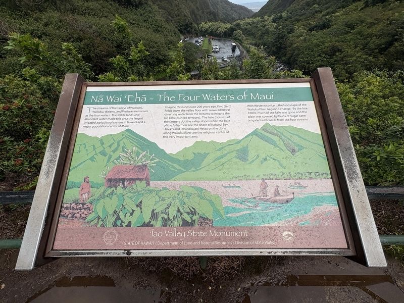
The steams of the valleys of Waikapu, Wailuku, Waiehuu, and Waihe'e are known as the four waters. The fertile lands and abundant water made this area the largest irrigated agricultural system in Hawai'i and a major population center of Maui.
Imagine this landscape 200 years ago, Kalo (taro) fields cover the valley floor with 'auwai (ditches) diverting water from the streams to irrigate the lo'i kalo (planted terraces). The hale (houses) of the farmers dot the valley slopes while the hale of the fishermen line the shore of Kahului Bay. Haleki'i and Pihanakalani Heiau on the dune along Wailuku River are the religious center of this very important area.
With Western contact, the landscape of the Wailuku Plain began to change. By the late 1800s, much of the kalo was gone and the plain was covered by fields of sugar cane irrigated with water from the four streams.
Topics. This historical marker is listed in these topic lists: Agriculture • Indigenous Peoples and Communities • Natural Resources • Religion & Religious Structures.
Location. 20° 52.827′ N, 156° 32.794′ W.
this page online

Regionally, this marker is in Lahaina and West Maui. Globally, it is in North America, Polynesia, the Pacific Ocean, North Pacific, the Pacific Rim, the Western Hemisphere, the Western World, and the Anglosphere.
Other nearby markers. At least 8 other markers are within walking distance of this marker: Kūka'emoku - 'Īao Needle (a few steps from this marker); Battle of Kepaniwai - Uniting the Islands (within shouting distance of this marker); Lā'au - The Plants of 'Īao (within shouting distance of this marker); Wahi Pana o Nā Ali'i (Sacred Place of the Chiefs) (about 400 feet away, measured in a direct line); Ka 'Ikena o 'Īao - Sites of 'Īao (about 400 feet away); Ka Wai Ola O Kāne (The Living Waters of Kāne) (about 400 feet away); Kūka‘emoku (about 400 feet away); Dedicated to the victims of the March 11, 2011 earthquake and tsunami in Japan
Photographed by Darren Jefferson Clay, December 7, 2025
2. Na Wai 'Eha - The Four Waters of Maui Marker
Credits. This page was last revised on February 5, 2026. It was originally submitted on February 1, 2026, by Darren Jefferson Clay of Duluth, Georgia. This page has been viewed 98 times since then. Photos: 1, 2. submitted on February 4, 2026, by Darren Jefferson Clay of Duluth, Georgia. • Devry Becker Jones was the editor who published this page.
