Madison in Dane County, Wisconsin — The American Midwest (Great Lakes)
The Madison Metropolitan Sewerage District Wildlife Observation Area
⎯⎯⎯
From Wastewater to Habitat
A Part of Capital Springs Recreation Area
| — | The environment is a beautiful thing, and we can all play a role in keeping it that way. | — |

Photographed by McGhiever, July 24, 2025
1. The Madison Metropolitan Sewerage District Wildlife Observation Area Marker
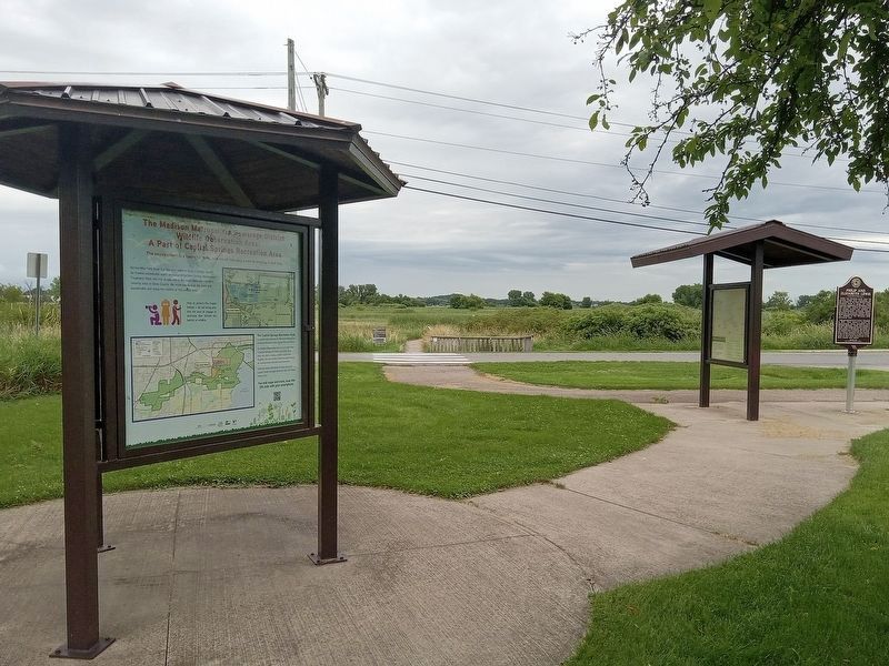
Across Moorland Road is a 140-acre wetland. Once a storage lagoon for treated wastewater solids produced at the Nine Springs Wastewater Treatment Plant, the area is now one of the most important shorebird viewing sites in Dane County. We invite you to walk the trails and boardwalks and enjoy the wildlife of this unique area.
The Capital Springs Recreation Area is a partnership between the Wisconsin Department of Natural Resources, Dane County Parks and others.
Our Wildlife Observation Unit is one of eight units in Capital Springs. At a little over 2,500 acres, each unit offers a unique outdoor experience. Together, the area creates numerous opportunities for environmental education and recreation.
Find even more information on each unit at the Lussier Family Heritage Center on Lake Farm Road (hours vary).
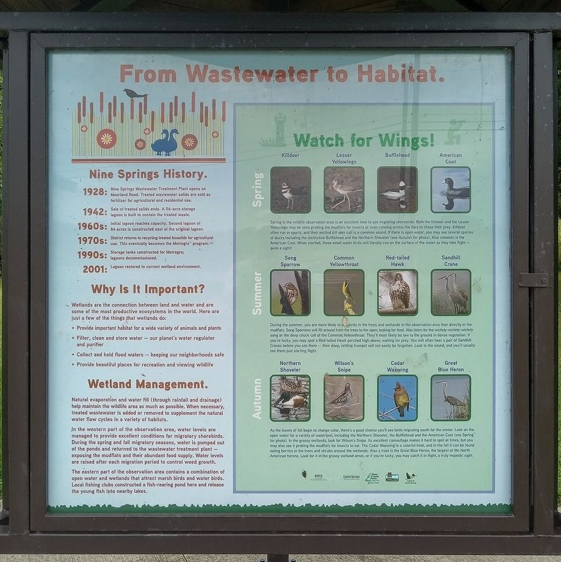
1942: Sale of treated solids ends. A 56-acre storage lagoon is built to contain the treated waste.
1960s: Initial lagoon reaches
this page online
1970s: District returns to recycling treated biosolids for agricultural use. This eventually becomes the Metrogro™ program.
1990s: Storage tanks constructed for Metrogro; lagoons decommissioned.
2001: Lagoon restored to current wetland environment.
• Provide important habitat for a wide variety of animals and plants
• Filter, clean and store water—our planet's water regulator and purifier
• Collect and hold flood waters—keeping our neighborhoods safe
• Provide beautiful places for recreation and viewing wildlife
In the western part of the observation area, water levels are managed to provide excellent
Photographed by McGhiever, July 24, 2025
2. From Wastewater to Habitat marker
The eastern part of the observation area contains a combination of open water and wetlands that attract marsh birds and water birds. Local fishing clubs constructed a fish-rearing pond here and release the young fish into nearby lakes.
Watch for Wings! Spring: Killdeer • Lesser • Yellowlegs • Bufflehead • American Coot
Spring in the wildlife observation area is an excellent time to see migrating shorebirds. Both the Killdeer and the Lesser Yellowlegs may be seen probing the mudflats for insects or even running across the flats to chase their prey. Killdeer often run in spurts, and their excited kill-deer call is a common sound. If there is open water, you may see several species of ducks including the distinctive Bufflehead and the Northern Shoveler (see Autumn for photo). Also common is the American Coot. When startled, these smallwater birds will literally run on the surface of the water as they take flight--quite a sight!Photographed by McGhiever, July 24, 20253. Marker kiosk across the road from the trail to the observation area
Summer: Song Sparrow • Common Yellowthroat • Red-tailed Hawk • Sandhill Crane
During the summer, you are more likely to see birds in the trees and wetlands in the observation area than directly in the mudflats. Song Sparrows will flit around from the trees to the open, looking for food. Also listen for the wichety-wichety-wichety song or the deep chuck call of the Common Yellowthroat. They'll most likely be low to the ground in dense vegetation. If you're lucky, you may spot a Red-tailed Hawk perched high above, waiting for prey. You will often hear a pair of Sandhill Cranes before you see them--their deep, rattling trumpet will not be easily forgotten. Look to the sound, and you'll usually see them just starting flight.
Autumn: Northern Shoveler • Wilson's Snipe • Cedar Waxwing • Great Blue Heron
As the leaves of fall begin to change color, there's a good chance you'll see birds migrating south for the winter. Look on the open water for a variety of waterfowl, including the Northern Shoveler, the Bufflehead and the American Coot (see Spring for photos). In the grassy wetlands, look for Wilson's Snipe. Its excellent camouflage makes it hard to spot at times, but you may also see it probing the mudflats for insects to eat. The Cedar Waxwing is a colorful treat, and in the fall it can be found eating berries in the trees and shrubs around the wetlands. Also a treat is the Great Blue Heron, the largest of the North American herons. Look for it in the grassy wetland areas, or if you're lucky, you may catch it in flight, a truly majestic sight.
Erected by Dane County Parks, Wisconsin Department of Natural Resources, et al.
Topics. This historical marker is listed in these topic lists: Industry & Commerce • Parks & Recreational Areas • Waterways & Vessels. A significant historical year for this entry is 1928.
Location. 43° 1.882′ N, 89° 20.952′ W. Marker is in Madison, Wisconsin, in Dane County. It is on Moorland Road, on the right when traveling east. The marker is at the Lewis Nine Springs E-Way parking lot. Touch for map. Marker is in this post office area: Madison WI 53713, United States of America. Touch for directions.

Regionally, this marker is in Southeast Wisconsin. It is also in the American Midwest and in the Corn Belt. Globally, it is in North America, the Western Hemisphere, the Western World, and the Anglosphere. Historically, it finds itself in what was once the territory of the Mississippian Culture and also the Northwest Territory.
Other nearby markers. At least 8 other markers are within walking distance of this marker: The Lewis Nine Springs E-Way / Philip and Elizabeth Lewis (a few steps from this marker); MMSD Wildlife Observation Area (a few steps from this marker); Lewis Nine Springs E-Way (within shouting distance of this marker); In Memory of Bud Morton 1907-1992 (approx. 0.2 miles away); The Gilman Mounds (approx. 0.4 miles away); Mounds for the Future (approx. 0.4 miles away); Destroying and Saving a Sacred Landscape (approx. 0.4 miles away); Carlos J. Martin Memorial Native American Interpretive Site (approx. 0.9 miles away). Touch for a list and map of all markers in Madison.
Credits. This page was last revised on February 21, 2026. It was originally submitted on February 4, 2026, by McGhiever of Minneapolis, Minnesota. This page has been viewed 42 times since then. Photos: 1, 2, 3. submitted on February 4, 2026, by McGhiever of Minneapolis, Minnesota.
