Norfolk Naval Shipyard in Portsmouth, Virginia — The American South (Mid-Atlantic)
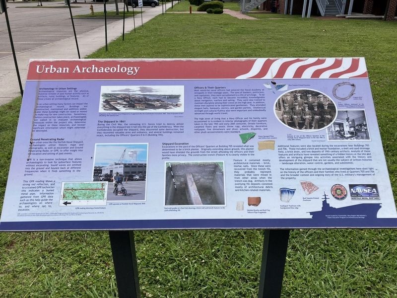
Urban Archaeology
circa 2024
1. Urban Archaeology Marker
Archaeological resources are the physical, material remains of past human activity such as artifacts, ruins, buildings, or features. All of these create an archaeological record.
In an urban setting many factors can impact the archaeological record. Buildings are constructed, maintained and additions added. Later these buildings might be razed or oved to make way for new construction. Sometimes, before construction takes place, archaeologists are called in to evaluate archaeological resources within the project site, determine the impact on these resources, and recover significant information which might otherwise be destroyed.
Ground Penetrating Radar
In an urban area like the Norfolk Naval Shipyard, archaeologists utilize historic maps and photographs, as well as excavation and Ground Penetrating Radar, or GPR, to offer insight into the location and setting of past events.
GPS is a non-invasive technique that allows archaeologists to look for subsurface features without excavating. Sound waves are emitted into the ground and bounce back at different frequencies when it finds something
this page online
This GPS reading shows a strong red reflection, and to a trained GPR technician this indicates a buried metal pipe. Information gathered from GPR data such as this help guide the archaeologists on where to, and where not to, excavate.
The Shipyard in 1861
During the Civl War, the retreating U.S. forces tried to destroy almost everything in the shipyard lest it fall into the use of the Confederacy. When the Confederates occupied the shipyard, they discovered some destruction, but they recovered valuable arms and ordnance, and several buildings remained intact, including the Officers' Quarters D & E (Building 705).
Officers & Their Quarters
Most would-be naval officers had entered the Naval Academy at Annapolis in their teenage years. The sons of bankers, politicians, and capitalists, they were accustomed to a life of privilege. To be a Navy Officer, each had to become incredibly knowledgeable about navigation, warfare and sailing. They were also trained to maintain discipline among the crews on the high seas. In addition, these men aspired to be sophisticated gentlemen. They attended elegant balls, banquets,

circa 2024
2. Quarters D & E
As referenced on the marker. The wing nearest appears to be a later addition.
The high level of living that a Navy Officer and his family were accustomed to is evident in interior photographs of their quarters taken in the late 19th and early 20th centuries. Ornate furniture, carpeted floors and exotic throw rugs, electricity, decorative wallpaper, fine dinnerware and silver, artwork, draperies, and other plush accoutrements were standard.
Shipyard Excavation
Excavations in the yard of the Officers' Quarters at Building 705 revealed what was determined to be a brick planter .Originally extending above ground, this planter would have shielded the grounds from the street affording the officers and their families more privacy. The construction trench (Feature 4) is clearly visible in the profile.
Feature 4 contained mostly architectural materials - brick, mortar, nails. Since these were recovered from the trench fill, they probably represent materials that were mixed in from other areas when the trench was dug. Artifacts in the overlying fill deposits consisted mostly

circa 2024
3. Quarters D & E
This view shows the original section of this Officers Quarters duplex, built in 1830.
Additional features were also located during the excavations near Buildings 705 and 706. These included a brick and mortar foundation, a shell and sand drainage field, a brick drain, and two deposits of 18th century artifacts. Analysis of these features and artifacts have revealed something of a hidden history at the site and offers an intriguing glimpse into activities associated with the history and development of the shipyard that are not usually the subject of written histories - landscape alteration, water control, gardens, and subsistence.
The information gained through the archaeological investigations here shed light on the history of the officers and their families who lived at Quarters 705 and 706 and the broader context and ongoing story of the U.S. military's management of the property.
(Photo Captions)
Depiction of the Norfolk Naval Shipyard as it appeared after the Confederate evacuation, 1861. Area of Quarters D & E (Building 705) noted in red.
GPR reading showing a buried feature.
GPR operator at Norfolk Naval Shipyard, 2010.
East wall profile of a Test Unit showing a brick wall and trench features in the yard at Building 705.
Interior of one of the Officers Quarters at the Norfolk Naval Shipyard taken in the late 19th or early 20th century.
Senior Officers stationed at the Norfolk Naval Shipyard in the 1920s.
(Artifacts)
Green Sponged Ware and Yellowware Ceramics
Molded Kaolin and Red Clay Tobacco Pipe Fragments
Scalloped pearlware with handpainted blue edge
Red Transfer Printed Pearlware
Blue Transfer Printed Porcelain
Copper alloy curtain ring
Erected by Commander, Navy Region Mid-Atlantic.
Topics. This historical marker is listed in these topic lists: Anthropology & Archaeology • War, US Civil.
Location. 36° 49.314′ N, 76° 17.687′ W. Marker is in Portsmouth, Virginia. It is in Norfolk Naval Shipyard. It is on Renshaw Avenue south of Breese Street, on the right when traveling south. Marker is within Norfolk Naval Shipyard and access is restricted to authorized personnel and their escorted guests. Touch for map. Marker is in this post office area: Portsmouth VA 23709, United States of America. Touch for directions.

Regionally, this marker is in Hampton Roads, specifically in Coastal Virginia, and in the Hampton Roads Metropolitan Area. It is also in the American South, specifically in the Upper South, in the Tidewater, and on the Eastern Seaboard. Globally, it is in the North Atlantic Region, North America, the Western Hemisphere, the Western World, and the Anglosphere. Historically, it finds itself in what was once the territory of the Mississippian Culture, one of the original Thirteen Colonies, one of the Confederate States of America, and the Antebellum South.
Other nearby markers. At least 8 other markers are within walking distance of this marker: Gosport Shipyard (about 500 feet away, measured in a direct line); Norfolk Naval Shipyard (about 600 feet away); Historical Marker (approx. 0.3 miles away); Commemorating 200th Anniversary Norfolk Naval Shipyard (approx. 0.3 miles away); The U.S. Shipyard (approx. 0.3 miles away); Drydock Number One (approx. 0.3 miles away); The Labor Force (approx. 0.3 miles away); Assisting Mariners with Navigation (approx. 0.4 miles away). Touch for a list and map of all markers in Portsmouth.
Additional commentary.
1. Confederate Evacuation
Note that it was the U.S., not the Confederacy, that evacuated the shipyard in 1861. The caption giving the Confederate evacuation as 1861 is in error. The Confederates evacuated in 1862.
— Submitted February 10, 2026, by Evan Dwyer of Richmond, Virginia.
Credits. This page was last revised on February 12, 2026. It was originally submitted on February 10, 2026. This page has been viewed 63 times since then. Photos: 1, 2, 3. submitted on February 10, 2026. • Bernard Fisher was the editor who published this page.
