Salida in Chaffee County, Colorado — The American Mountains (Southwest)
New Faces Along the River
| — | Collegiate Peaks Scenic and Historic Byway | — |

Photographed by Cosmos Mariner, July 23, 2025
1. New Faces Along the River Marker
Life changed rapidly in the Upper Arkansas River Valley with the arrival of European explorers and the United States settlers.
Spanish presence in the area and their interaction with local Utes was recorded as early as 1626, but official exploration of southwest Colorado by Spain did not begin for another 150 years.
In 1779 General Juan Bautista de Anza, then governor of New Mexico, set out on a campaign against the Comanche people. General de Anza's quest resulted in the first recorded crossing of Poncha Pass.
In 1801, after learning that Spain had ceded the Louisiana Territory back to France, United States President Thomas Jefferson sent James Monroe and Robert Livingston to Paris to negotiate the purchase of the port of New Orleans. To their great surprise, negotiators succeeded in acquiring not just New Orleans, but the entire 828,800 square miles of the territory in 1803.
The southern boundary of the Louisiana Purchase where it met New Spain was unclear at the time of purchase and, in 1806, Lieutenant Zebulon Montgomery Pike was sent west to seek more information about the United States' new southwestern boundary.
this page online
[photo captions]
• Juan Bautista de Anza, California State University photo.
• Zebulon Pike
Upper Arkansas Valley Timeline
1598 • Spanish settle in present day New Mexico
1626 • Earliest reference to Utes by Spanish
1670 • First treaty between Utes and Spanish
1765 • Juan Maria de Rivera leads first official Spanish expedition into southwest Colorado through Ute lands
1779 • Juan Bautista de Anza's campaign against the Comanche people brings him through present day Poncha Springs
1803 • French sell the Louisiana Territory to the United States
1806-07 • Zebulon Pike's expedition searches for the boundary of the Louisiana Purchase
1850 • G.A. Kelley discovers gold on the Arkansas four miles south of Granite
1860 • Abe Lee discovers gold in California Gulch near Leadville
1876 • Colorado becomes a state
Erected by Federal Highway Administration, National Scenic Byways, and Greater Arkansas River Association.
Topics. This historical marker is listed in these topic lists: Exploration • Hispanic Americans • Indigenous Peoples and Communities

courtesy iStock photo
2. Marker detail: Zebulon Pike
Location. 38° 35.528′ N, 106° 5.112′ W. Marker is in Salida, Colorado, in Chaffee County. It is on U.S. 285 5 miles north of U.S. 50, on the left when traveling north. The marker is located at the Christmas 1806 Picnic Ground wayside. Touch for map. Marker is at or near this postal address: 12025 US Highway 285, Salida CO, United States of America. Touch for directions.

Regionally, this marker is in the Arkansas River Valley, in the Colorado High Rockies and on the Continental Divide. It is also in the American Mountain West. Globally, it is in North America, the Rocky Mountains, the Western Hemisphere, the Western World, and the Anglosphere.
Other nearby markers. At least 8 other markers are within 5 miles of this marker, measured as the crow flies: Finding Our Roots (here, next to this marker); Pike Explores the Valley (here, next to this marker); Christmas 1806 (a few steps from this marker); The Faces of Industry (approx. 4.3 miles away); Remnant of an Era (approx. 4.3 miles away); A Valley Landmark (approx. 4.3 miles away); The Roof of the Rockies

3. Marker detail: Juan Bautista de Anza
August 15 – September 10, 1779
August 15 – September 10, 1779
Related markers. Click here for a list of markers that are related to this marker.
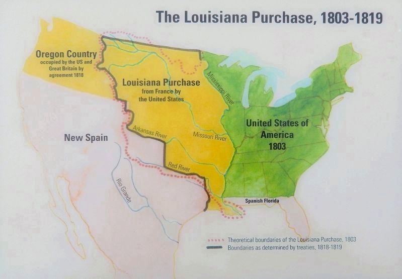
4. Marker detail: The Louisiana Purchase, 1803-1819
The boundary of the Louisiana Purchase changed during the years that followed its acquisition by the United States in 1803. Early agreements defined the boundary south of the Red River in what is now Texas, but through treaties in 1818-1819, the official line was drawn along portions of the Red River and the Arkansas River.

Photographed by Cosmos Mariner, July 23, 2025
5. New Faces Along the River Marker
This marker is the center one of three related interpretive panels at the Christmas 1806 Picnic Ground wayside.
Credits. This page was last revised on February 16, 2026. It was originally submitted on February 14, 2026, by Cosmos Mariner of Cape Canaveral, Florida. This page has been viewed 52 times since then. Photos: 1, 2, 3, 4, 5. submitted on February 16, 2026, by Cosmos Mariner of Cape Canaveral, Florida.
