Yorktown in York County, Virginia — The American South (Mid-Atlantic)
The Washington-Rochambeau Route to Victory
Yorktown Battlefield
| — | Colonial National Historical Park | — |
Photographed by Bill Coughlin, August 12, 2008
1. The Washington – Rochambeau Route to Victory Marker
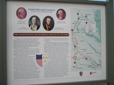
On August 14, 1781, Generals Washington and Rochambeau received news that a large French fleet under the command of Admiral de Grasse was headed for the Chesapeake Bay carrying 3,000 French soldiers. There the British general, Lord Cornwallis, was encamped with his army at Yorktown, Virginia. The two allied leaders promptly decided to lead their armies southward for 450 miles to engage Cornwallis at the siege which proved to be the pinnacle engagement of the Revolutionary War.
Their route started at White Plains, New York, and included a crossing of the Hudson River at Stony Point, New York. Stops were made at both Princeton and Philadelphia. At Chester, Pennsylvania, on September 5, Washington learned that de Grasse had reached Virginia and had landed the troops at Jamestown under the command of General Saint-Simon.
American watercraft managed to transport some of the allied foot soldiers down the Chesapeake from Head-of-Elk (now Elkton, Maryland) to Annapolis. The rest of the troops continued overland to Annapolis, where the infantry units halted to await boat lift further south. The allied field artillery, supply trains,
this page online
Washington and Rochambeau, accompanied by a few of their staff officers, took a different route from the main army. From Baltimore, they crossed the Potomac River at Georgetown (now part of Washington, D.C.), passed through Alexandria, Virginia, and then stopped briefly at Mount Vernon, Washington’s plantation home, which he had not visited for more than six years. To prepare for his French guests, Washington rode ahead of the party and covered a remarkable 60 miles in one day. Rochambeau and the staff officers arrived the next day. The allied commanders rested at Mount Vernon on September 10 and 11. On September 12, they rode on toward Fredericksburg.
When the allied commanders were passing near the village of Dumfries, a rider brought dispatches reporting that the British fleet of Admiral Graves had been sighted off the entrance to the Chesapeake Bay, and that Admiral de Grasse had sailed

Photographed by Evan Dwyer, January 5, 2026
2. The Washington – Rochambeau Route to Victory Marker
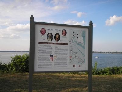
Times change; trees grow. The viewshed is obscured.
News of the naval battle led Generals Washington and Rochambeau to hasten to Williamsburg. After spending the night of September 12 in Fredericksburg, they rode through Hanover Court House and New Kent Court House, and arrived at Williamsburg on the fourteenth. There they met General Lafayette, who commanded the American forces in Virginia during the summer. The allied armies assembled supplies and equipment and, with the arrival of wagon trains and troops from the long march, moved forward on September 28 to start the
Photographed by Bill Coughlin, August 12, 2008
3. Marker on the Yorktown Battlefield
Erected by National Park Service, U.S. Department of the Interior; The Virginia Daughters of the American Revolution.
Topics and series. This historical marker is listed in these topic lists: Notable Events • Notable Places • War, US Revolutionary. In addition, it is included in the Daughters of the American Revolution (DAR), the Former U.S. Presidents: #01 George Washington, and the The Washington-Rochambeau Route series lists. A significant historical month for this entry is September 1638.
Location. 37° 14.455′ N, 76° 31.263′ W. Marker is in Yorktown, Virginia, in York County. It is on Fusiliers Redoubt ramp east of Colonial National Historical Pkwy, on the left when traveling east. Touch for map. Marker is at or near this postal address: 100C Water St, Yorktown
Photographed by Bill Coughlin, August 12, 2008
4. Marker on the York River

Regionally, this marker is on Virginia’s Peninsula, in Coastal Virginia, and in the Hampton Roads Metropolitan Area. It is also in the American South, specifically in the Upper South, in the Tidewater, and on the Eastern Seaboard. Globally, it is in the North Atlantic Region, North America, the Western Hemisphere, the Western World, and the Anglosphere. Historically, it finds itself in what was once the territory of the Mississippian Culture, one of the original Thirteen Colonies, one of the Confederate States of America, and the Antebellum South.
Other nearby markers. At least 8 other markers are within walking distance of this marker: French Trench (a few steps from this marker); French Forces Memorial (within shouting distance of this marker); Yorktown French Memorial (within shouting distance of this marker); a different marker also named French Trench (within shouting distance of this marker); Fusiliers Redoubt (within shouting distance of this marker); Washington-Rochambeau Route (about 800 feet away, measured in a direct line); Massachusetts (approx. 0.2
Photographed by Bill Coughlin, August 10, 2008
5. Route to Victory Marker at Mount Vernon
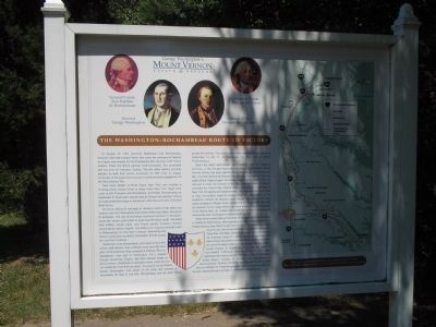
This similar marker is located in Mount Vernon, VA.
More about this marker. A shield of the American and French flags appears in the center of the marker. The top of the marker features portraits of two American and two French leaders at Yorktown. A map showing the route taken by Washington and Rochambeau from Mount Vernon to Yorktown appears on the right of the marker.
Related markers. Click here for a list of markers that are related to this marker. 'Sister' displays in Virginia commemorating the route taken by Generals Washington and Rochambeau, to Yorktown in September 1781.
Also see . . .
1. Yorktown Battlefield. National Park Service. (Submitted on September 2, 2008, by Bill Coughlin of Woodland Park, New Jersey.)
2. The Battle of Yorktown. The Patriot Resource website. (Submitted on September 2, 2008, by Bill Coughlin of Woodland Park, New Jersey.)
3. The Battle of Yorktown 1781. A British perspective of the Battle of Yorktown from BritishBattles.com. (Submitted on September 2, 2008, by Bill Coughlin of Woodland Park, New Jersey.)
Credits. This page was last revised on February 16, 2026. It was originally submitted on September 2, 2008, by Bill Coughlin of Woodland Park, New Jersey. This page has been viewed 2,184 times since then and 87 times this year. Last updated on February 15, 2026, by Evan Dwyer of Richmond, Virginia. Photos: 1. submitted on September 2, 2008, by Bill Coughlin of Woodland Park, New Jersey. 2. submitted on February 15, 2026, by Evan Dwyer of Richmond, Virginia. 3, 4, 5. submitted on September 2, 2008, by Bill Coughlin of Woodland Park, New Jersey. • Devry Becker Jones was the editor who published this page.
