
San Luis in Costilla County, Colorado — The American Mountains (Southwest)
Oldest Town in Colorado
Photographed by Cosmos Mariner, July 12, 2025
1. Oldest Town in Colorado Marker
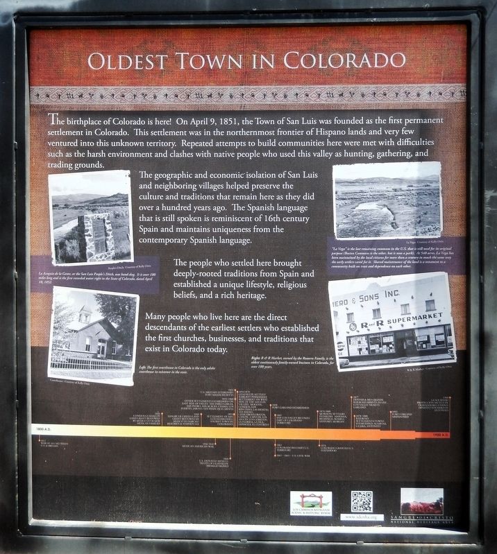
The birthplace of Colorado is here! On April 9, 1851, the Town of San Luis was founded as the first permanent settlement in Colorado. This settlement was in the northernmost frontier of Hispano lands and very few ventured into this unknown territory. Repeated attempts to build communities here were met with difficulties such as the harsh environment and clashes with native people who used this valley as hunting, gathering, and trading grounds.
The geographic and economic' isolation of San Luis and neighboring villages helped preserve the culture and traditions that remain here as they did over a hundred years ago. The Spanish language that is still spoken is reminiscent of 16th century Spain and maintains uniqueness from the contemporary Spanish language.
The people who settled here brought deeply-rooted traditions from Spain and established a unique lifestyle, religious beliefs, and a rich heritage.
Many people who live here are the direct descendants of the earliest settlers who established the first churches, businesses, and traditions that exist in Colorado today.
[photo captions]
• La Acequia de la Gente, or the San
this page online
• The first courthouse in Colorado is the only adobe courthouse in existence in the state.
• “La Vega” is the last remaining commons in the U.S. that is still used for its original purpose (Boston Commons is the other, but is now a park). At 540 acres, La Vega has been maintained by the local citizens for more than a century in much the same way the early settlers cared for it. Shared maintenance of the land is a testament to a community built on trust and dependence on each other.
• R & R Market, owned by the Romero Family, is the oldest continuously family-owned business in Colorado, for over 100 years.
Timeline [across bottom of interpretive panel]
1812 • War of 1812 between U.S. & Britain
1832 • Conejos Guadalupe Land Grant bestowed by Mexico to 50 New Mexican families
1843 • Sangre de Cristo Land Grant bestowed by Mexico to Narcisco Beaubien & Stephen Lee
1846-1848 • Mexican American War
1848 • U.S. defeated Mexico, Treaty of Guadalupe Hidalgo signed
1851 • Settlement of San Luis established
Photographed by Cosmos Mariner, July 12, 2025
2. Oldest Town in Colorado Marker
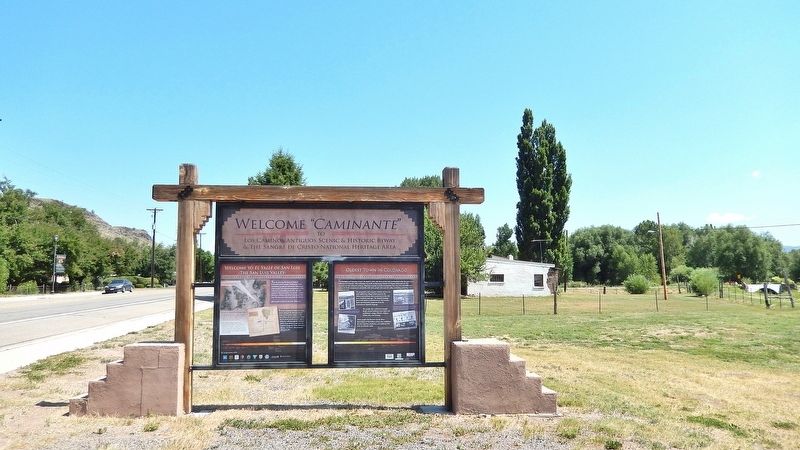
Welcome “Caminante” — to Los Caminos Antiguos Scenic & Historic Byway and The Sangre de Cristo National Heritage Area
Looking north. This marker is the rightmost of two interpretive panels on the south side of the Los Caminos Antiguos Scenic & Historic Byway kiosk in San Luis. Main Street (Colorado Highway 159) is on the left.
Looking north. This marker is the rightmost of two interpretive panels on the south side of the Los Caminos Antiguos Scenic & Historic Byway kiosk in San Luis. Main Street (Colorado Highway 159) is on the left.
1852 • U.S. military establishes Fort Massachusetts
1852-1860 • Other settlements established on east side of valley: San Pablo Garcia, San Pedro, San Acacio, Chama, Los Fuertes, Jaroso, San Francisco, Mesita
1854-1870 • Guadalupe settled (earliest permanent settlement on west side of the San Luis Valley): Mogote, Conejos, Los Rincones, Las Mesitas, San Rafael, Ceniceros/Lobatos, Cañon, Capulin, Los Sauces, Los Cerritos, La Florida, La Isla, Espinoza, El Centrito
1858 • Fort Garland established
1861 • San Luis Valley becomes part of Colorado Territory
1861 • Colorado becomes U.S. Territory
1861-1865 • U.S. Civil War
1874-1888 • Mormon settlers establish: Manassa, Richfield, Romeo, Sanford, Morgan
1876 • Colorado granted U.S. statehood
1877 • Denver & Rio Grande Railroad arrives in San Luis Valley near Fort Garland
1878-1880 • Railroad settlements/towns established: Alamosa, La Jara, Antonito
1883 • Fort Garland abandoned
1900 • La Sociedad Protección Mutua de Trabajadores Unidos (SPMDTU) founded in Antonito
Erected by Colorado Scenic and Historic Byways Commission, Colorado Historical Society, Colorado Department of

Photographed by Cosmos Mariner, July 12, 2025
3. San Luis People’s Ditch
It crosses Main Street (Colorado Highway 159) ½-mile south of this historical marker.
Topics. This historical marker is listed in these topic lists: Hispanic Americans • Indigenous Peoples and Communities • Settlements & Settlers. A significant historical date for this entry is April 9, 1851.
Location. 37° 12.135′ N, 105° 25.525′ W. Marker is in San Luis, Colorado, in Costilla County. It is on Main Street (State Highway 159) just north of 6th Street, on the right when traveling north. The marker is near the sidewalk on the west side of San Luis Community Park. Touch for map. Marker is at or near this postal address: 650 Main Street, San Luis CO 81152, United States of America. Touch for directions.

Regionally, this marker is in Colorado’s San Juan Mountains and in the San Luis Valley. It is also in the American Mountain West. Globally, it is in North America, the Rocky Mountains, the Western Hemisphere, the Western World, and the Anglosphere. Historically, it finds itself in what was once New Spain and also the Republic of Texas.
Other nearby markers. At least 8 other markers are within walking distance of this marker: Welcome to El Valle de San Luis (here,

Photographed by Cosmos Mariner, July 12, 2025
4. Costilla County Courthouse
It is on Main Street (Colorado Highway 159) 0.3 miles south of this historical marker.
Related markers. Click here for a list of markers that are related to this marker. San Luis, Colorado
Also see . . . San Luis, Colorado (Wikipedia).
Excerpt: Armed traders traveled the Old Spanish Trail through the area in the early 19th century. San Luis was in the Sangre de Cristo Land Grant awarded by the government of New Mexico to the Carlos Beaubien family in 1843. Hispanic settlers from the Taos Valley established several small villages along the Rio Culebra in the San Luis Valley and officially took possession of this portion of the Sangre de Cristo Land Grant on April 9, 1851. The settlers built a church in the central village of La Plaza Medio. They dedicated it on the Feast of Saint Louis,(Submitted on March 2, 2026, by Cosmos Mariner of Cape Canaveral, Florida.)June 21, 1851, renaming the village San Luis de la Culebra in honor of the saint. The village of San Luis remained part of the Territory of New Mexico until 1861 when the Territory of Colorado was established. Colorado became a state in 1876 and the Town of San Luis was incorporated in 1885. Today, San Luis is the oldest continuously inhabited town in the State of Colorado.Photographed by Cosmos Mariner, July 12, 20255. R & R MarketIt is on Main Street (Colorado Highway 159) ¼-mile south of this historical marker.

Credits. This page was last revised on March 2, 2026. It was originally submitted on February 26, 2026, by Cosmos Mariner of Cape Canaveral, Florida. This page has been viewed 39 times since then. Photos: 1, 2, 3, 4, 5. submitted on March 2, 2026, by Cosmos Mariner of Cape Canaveral, Florida.
