Bertrand in Phelps County, Nebraska — The American Midwest (Upper Plains)
Sarepta Gore Fly

Photographed by Susan Van Den Bosch, February 24, 2026
1. Sarepta Gore Fly Marker
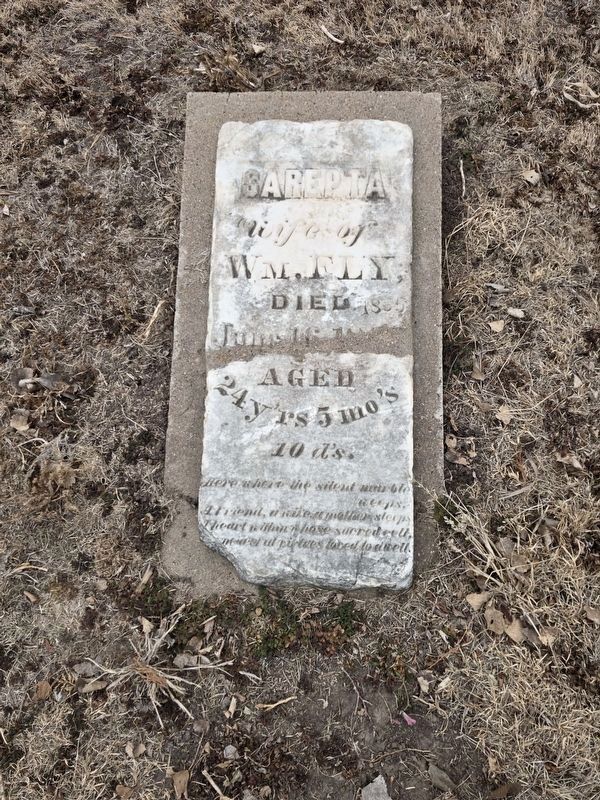
The exact location of the Sarepta Fly grace is unknown. The headstone marking her grave was discovered early this century by children playing in a field on the old Dilworth Ranch, not far from this location. It had been covered by prairie grasses and was found half-buried in an animal burrow.
Sarepta Gore, the daughter of Jame Gore of Andrew County, Missouri, was born January 6, 1841. In 1857 she married William Fly, a twenty-seven-year-old native of Howard County, Missouri. Fly went to the California gold mines in 1852 and remained there for five years. Sarepta and William were married upon his return to Missouri. The Flys soon took up farming in Kansas, but after three years there they joined the Colorado gold rush and crossed the Plains to a Rocky Mountain mining town.
In 1865 the Fly family decided to return to Missouri. By this time William and Sarepta were the parents of three children: Carey B., born December 14, 1858; John Davis, born October 12, 1860; and James M., born April 21, 1863. When the family reached the Plum Creek area, Sarepta died. According to family tradition, her death was sudden and unexpected,
this page online
William Fly settled in Montana, where he again took up mining and later ranching. He remarried in 1872 and became a prominent citizen of the Bozeman area, where he died in December 1887.
The Sarepta Fly headstone was moved to this location in 1930 in preparation for the dedication of the Plum Creek Massacre marker and cemetery. The only actual burial within this cemetery plot, however, is that of a small, unidentified child whose remains were discovered on a farm near Loomis, Nebraska. The reinterment took place in 1963.
Erected 1995 by Oregon-California Trails Association; research for the sign by the Dawson County Historical Society.
Topics. This historical marker is listed in these topic lists: Cemeteries & Burial Sites

Photographed by Susan Van Den Bosch, February 24, 2026
2. View of Cemetery
Location. 40° 40.361′ N, 99° 36.349′ W. Marker is in Bertrand, Nebraska, in Phelps County. It is on B Road north of Local Road 748, on the left when traveling north. The marker stands within the Historic Plum Creek Cemetery at the Plum Creek Massacre Site. Touch for map. Marker is at or near this postal address: 10263 B Rd, Bertrand NE 68927, United States of America. Touch for directions.

Regionally, this marker is in Eastern Nebraska. It is also in the American Midwest, in the Corn Belt, and on the prairies. Globally, it is in North America, the Western Hemisphere, the Western World, and the Anglosphere. Historically, it finds itself in what was once the Louisiana Purchase.
Other nearby markers. At least 8 other markers are within 9 miles of this marker, measured as the crow flies: A different marker also named The Plum Creek Massacre (a few steps from this marker); Oregon Trail (a few steps from this marker); Pony Express (a few steps from this marker); Historic Plum Creek History (a few steps from this marker); Historic Plum Creek Cemetery Information & Directory
Photographed by Susan Van Den Bosch, February 24, 2026
3. Sarepta Gore Fly Headstone
Other markers no longer nearby. The Plum Creek Massacre (was here, next to this marker but has been replaced with another marker now near it); Plum Creek Massacre Site (was here, next to this marker but has been replaced with another marker now near it).
Credits. This page was last revised on March 10, 2026. It was originally submitted on March 3, 2026, by Susan Van Den Bosch of Almond, Wisconsin. This page has been viewed 69 times since then. Photos: 1, 2, 3. submitted on March 3, 2026, by Susan Van Den Bosch of Almond, Wisconsin. • Devry Becker Jones was the editor who published this page.
