
Merritton in St. Catharines in Niagara Region, Ontario — Central Canada (North America)
The 2nd Welland Canal Locks 14 and 15
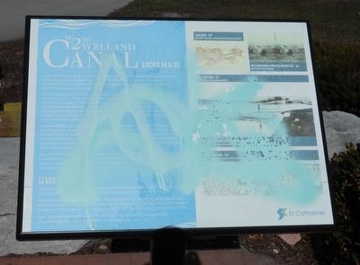
Photographed by Kevin Westell, March 9, 2026
1. The 2nd Welland Canal Locks 14 and 15 - Marker
The First Welland Canal (1829) was made of 40 wooden locks that were labouriously dug out by hand. The locks were 110 feet (33.5 metres) long by 22 feet (6.7 metres) wide and 8 feet (2.4 metres) deep, and were large enough to accommodate a sloop or small schooner. By 1841, the wooden locks had started to deteriorate, and larger steamboats were becoming more common. This led to the rebuilding and enlarging of the canal. The Second Welland Canal (1845) was hand dug with the assistance of dredges. It was made up of 27 limestone locks which were 150 feet (45.72 metres) long by 26.5 feet (80.77 metres) wide and 9 feet (2.75 metres) deep.
Merritton Bill Wiley Memorial Parkette sits over a buried channel of the Second Welland Canal between Lock 14 (buried at the north of the park) and Lock
this page online
After the Third Welland Canal (1881) was built to accommodate larger vessels, the Second Welland Canal remained in operation in order to service local mills. Much of the Second Welland Canal in this area was drained in 1961, leaving only the green spaces and stone locks as a reminder of the former navigation route.
Leveraging Bar
Quarrying limestone in the Niagara Peninsula has been an important industry for over two hundred years. Cut and crushed stone was in demand for roads, canal works and other infrastructure.
During the 19th century, this iron bar was used by quarry men as a lever to help move and position large limestone blocks. There is a shackle located at the balance point of the bar, and another located at the smaller end of the

Photographed by Kevin Westell, March 9, 2026
2. The 2nd Welland Canal Locks 14 and 15 - Marker in context
Photo faces north-west from near Glendale Ave. The marker (centre right) is at the handlebar of that bike.
Walker Industries donated the bar in 1983 to enhance the "Walker Mile of the Merritt Trail" which follows the First and Second Welland Canals through the city.
Erected by City of St. Catharines.
Topics and series. This historical marker is listed in these topic lists: Colonial Era • Waterways & Vessels. In addition, it is included in the The Welland Canals series list. A significant historical year for this entry is 1841.
Location. 43° 8.175′ N, 79° 12.99′ W. Marker has been reported unreadable. Marker is in St. Catharines, Ontario, in Niagara Region. It is in Merritton. It is at the intersection of Glendale Ave (Route 89) and Mountain St, on the right when traveling west on Glendale Ave. Touch for map. Marker is at or near this postal address: 320 Glendale Ave, St Catharines ON L2T 2S3, Canada. Touch for directions.

Regionally, this marker is on Ontario’s Golden Horseshoe and in Niagara Canada. It is also in Central Canada. Globally, it is in North America, on the Great Lakes, in the Western Hemisphere, in the Western

Photographed by Kevin Westell, March 9, 2026
3. Lock 13 and the south end of "Canal Valley"
The 2nd Welland canal's Lock 13 is 400 metres north of the marker. Photo looks north along the length of the lock. "Canal Valley" and its paved walking/biking trail (extreme left) start here and runs north for 1.5 miles (2.5 km), passing 8 locks (in various states of decay) along the way.
Other nearby markers. At least 8 other markers are within walking distance of this location: Merritton Bill Wiley Memorial Parkette (here, next to this marker); Johansson's Bar (a few steps from this marker); The Mountain Locks (about 180 meters away, measured in a direct line); Jacob Ball U.E.L. circa 1824 (approx. half a kilometer away); Merritton Town Hall 1879 (approx. half a kilometer away); Merritton Volunteer Fire Department (approx. half a kilometer away); Merritt Street at CNR Crossing (approx. 0.6 kilometers away); Lock 24 - First Welland Canal (approx. 0.6 kilometers away). Touch for a list and map of all markers in St. Catharines.
More about this marker. 1. Correction in the inscription: the width should say: "...26.5 feet (8.08 metres)..." . (Metric conversion slipped a decimal place).
2. List of images
- Lock map. Image Credit: Archives and Special Collections, Brock University
- Welland Canal through Merritton. Image credit:
Photographed by Kevin Westell, March 9, 2026
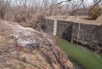
4. Lock 13's east wall, and the recess for the lower lock gate door
Photo looks north-east, across Lock 13. Water is flowing from right to left. In spite of some erosion of the rock, the 180-year-old stone work remains exquisite.
- You are here. Merritton Bill Wiley Memorial Parkette
- Second Welland Canal: Locks 14 and 15. Image credit: John Burtniak Postcard Collection, Map Data & GIS Library, Brock University
- Leveraging Bar. Image credit: Historical Atlas of Lincoln and Welland, Ontario, H.R. Page, 1876 [*Correction: Last title should be: Illustrated Historical Atlas of Lincoln and Welland, Ontario]
Regarding The 2nd Welland Canal Locks 14 and 15. This was the second of the four Welland Canals (the fourth being the current, operational canal). Its path followed close to the path of the first canal.
To clarify this from the inscription, "... the Second Welland Canal remained in operation in order to service local mills":
- Both the 1st and 2nd Welland canals supplied water power to mills; seventy years before electric power became available. In the 1870s, over a dozen mills were in Merritton, near this marker; and over a dozen downstream in St. Catharines.
- The current (4th) canal is similarly multi-purpose: ship traffic, electric power, drinking water, farm irrigation water.
Also see . . .
1. Exploring The Old Welland Canals - MyMaps. This shows the former paths of the 1st, 2nd and 3rd Welland canals. The 4th (current) Welland canal is also plainly visible. (Submitted on March 9, 2026, by Kevin Westell of St. Catharines, Ontario.)
2. Historic Welland Canals Mapping Project (HWCMP) - ARCGIS. This shows the former paths of the 1st, 2nd and 3rd Welland canals. The 4th (current) Welland canal is also plainly visible. (Submitted on March 9, 2026, by Kevin Westell of St. Catharines, Ontario.)
Credits. This page was last revised on March 9, 2026. It was originally submitted on March 9, 2026, by Kevin Westell of St. Catharines, Ontario. This page has been viewed 18 times since then. Photos: 1, 2, 3, 4. submitted on March 9, 2026, by Kevin Westell of St. Catharines, Ontario.
