Antonito in Archuleta County, Colorado — The American Mountains (Southwest)
Who Owns This Land?

Photographed by Cosmos Mariner, July 13, 2025
1. Who Owns This Land? Marker
Long before anyone claimed this land as their own, it was used for hunting, gathering, and spiritual pursuits by various groups of indigenous people. Navajos, Utes, Apaches, Pueblos, and other tribal groups migrated to and through the area.
Spanish explorers claimed the territory in the sixteenth century on behalf of the Spanish crown.
In 1821, the land became part of Mexico when that country gained independence from Spain. To develop and secure its northern territory, Mexico granted large plots of land to citizens. Much of this forest and the San Luis Valley to the east became the Conejos Land Grant.
When the United States defeated Mexico in 1848, the Treaty of Guadalupe Hidalgo guaranteed that all Mexican land grants would be honored. This was not to be the case. Grantees lost most, if not all, of their land. Land was divided into homesteads and other private land ownerships. Later, large pieces became federally managed lands.
[photo captions]
• Indian woman baking bread
• Original text of the treaty of Guadalupe Hidalgo
• Horno — Outdoor Oven
• Corn Stalk
Erected by Colorado Scenic and Historic Byways Commission,
this page online
Topics. This historical marker is listed in these topic lists: Hispanic Americans • Indigenous Peoples and Communities • Settlements & Settlers • War, Mexican-American. A significant historical year for this entry is 1821.
Location. 36° 59.947′ N, 106° 29.421′ W. Marker is in Antonito, Colorado, in Archuleta County. It is on State Highway 17 at milepost 0.7, on the left when traveling south. The marker is 0.7 miles north of the Colorado/New Mexico state line. Touch for map. Marker is in this post office area: Antonito CO 81120, United States of America. Touch for directions.

Regionally, this marker is on the Continental Divide. It is also in the American Mountain West and at the Four Corners. Globally, it is in North America, the Rocky Mountains, the Western Hemisphere, the Western World, and the Anglosphere. Historically, it finds itself in what was once the territory of the Ancestral Puebloans.
Other nearby markers. At least 8 other markers are within 4 miles of this marker, measured as the crow flies: Nurturing Forest
Photographed by Cosmos Mariner, July 13, 2025
2. Who Owns This Land? Marker
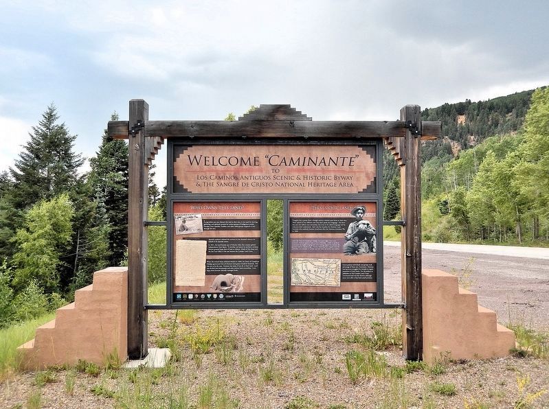
Welcome “Caminante” — to Los Caminos Antiguos Scenic & Historic Byway and The Sangre de Cristo National Heritage Area
This marker is the leftmost of two interpretive panels on the north side of the Los Caminos Antiguos Scenic & Historic Byway kiosk just north of the Colorado/New Mexico state line.
Looking south; Colorado Highway 17 is on the right.
This marker is the leftmost of two interpretive panels on the north side of the Los Caminos Antiguos Scenic & Historic Byway kiosk just north of the Colorado/New Mexico state line.
Looking south; Colorado Highway 17 is on the right.
Also see . . .
1. Land grants in New Mexico and Colorado (Wikipedia).
Excerpt: Land grants in New Mexico and Colorado were awarded to individuals and communities by the Spanish and Mexican governments to encourage settlement and expansion of the Territorio de Nuevo Mexico, which included southern Colorado. Land grants by the Spanish and Mexicans between 1692 and 1846 numbered 291 in New Mexico, four partly in New Mexico and partly in Colorado, and three in Colorado. The land area of grants totaled tens of thousands of square miles. The two major types of land grants were private grants made to individuals, and communal grants made to groups of people for the purpose of establishing settlements. Communal land grants were also made to Pueblos for the lands they inhabited. The principal objectives of the land grants were to encourage the foundation of new communities and to expand the settled area on the frontiers of New Mexico for defense from Native American raids.(Submitted on March 19, 2026, by Cosmos Mariner of Cape Canaveral, Florida.)After its conquest of New Mexico in 1846, the United States adjudicated the grants and confirmed 157 as valid. The peace treaty between the U.S. and Mexico in 1848 guaranteed the right of former Mexican citizens to their land, but the adherence to that language was inconsistent and compromised by U.S. legal actions which were often corrupt and biased in favor of White claimants and White land practices. By the early 20th century, the Hispano grantees and their descendants had lost a large percentage of the grant land to Whites and public domain national forests. Hispano protests, legal action, and occasional violence to regain or retain their traditional rights to usage of grant lands continued into the 21st century.
2. Mexican Land Grants and Disputed Territory–1830-1848 (SangreHeritage.org).
Excerpt: The Conejos Grant boundaries covered most of present-day Conejos and Rio Grande counties. It was described as “extending north to La Garita Mountains, east to the Rio Grande, south to San Antonio Peak, and west to Sierra Montosa.” The Conejos Grant was originally made not to an individual but rather to a group of 50 families on the condition that they affect a settlement on the grant. However, Indian hostility prevented them from beginning any attempts to settle the land until 1842.(Submitted on March 20, 2026, by Cosmos Mariner of Cape Canaveral, Florida.)
Credits. This page was last revised on March 20, 2026. It was originally submitted on March 19, 2026, by Cosmos Mariner of Cape Canaveral, Florida. This page has been viewed 22 times since then. Photos: 1, 2. submitted on March 19, 2026, by Cosmos Mariner of Cape Canaveral, Florida.
