North Quincy in Norfolk County, Massachusetts — The American Northeast (New England)
Moswetuset Hummock
1630 - 1930
Photographed by Russell C. Bixby, September 26, 2011
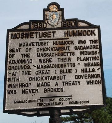
1. Moswetuset Hummock Marker
Moswetuset Hummock was the seat of Chickatawbut, Sagamore of the Massachusetts Indians; adjoining were their planting grounds. "Massachusetts" means "at the Great (Blue) Hills." With Chickatawbut Governor Winthrop made a treaty which was never broken.
Erected 1930 by Massachusetts Bay Colony-Tercentenary Commission.
Topics and series. This historical marker is listed in these topic lists: Colonial Era • Government & Politics • Indigenous Peoples and Communities • Settlements & Settlers. In addition, it is included in the Massachusetts Bay Colony—Tercentenary Commission Markers series list.
Location. 42° 17.254′ N, 71° 1.377′ W. Marker is in Quincy, Massachusetts, in Norfolk County. It is in North Quincy. It is on Quincy Shore Drive just east of East Squantum Street, on the right when traveling west. Touch for map. Marker is at or near this postal address: 321 Quincy Shore Dr, Quincy MA 02171, United States of America. Touch for directions.

Regionally, this marker is in Historic Boston and specifically in Greater Boston. It is also in the
this page online
Other nearby markers. At least 8 other markers are within one mile of this marker, measured as the crow flies: South of Boston Discovery Area (a few steps from this marker); a different marker also named Moswetuset Hummock (about 600 feet away, measured in a direct line); a different marker also named Moswetuset Hummock (about 700 feet away); WWII Paratroopers and Veterans Memorial (approx. 0.2 miles away); Squantum Point Through Time (approx. one mile away); Maloney Circle (approx. one mile away); New England's First Aero Meet (approx. one mile away); Harriet Quimby's Last Flight (approx. one mile away). Touch for a list and map of all markers in Quincy.
Related markers. Click here for a list of markers that are related to this marker. To better understand the relationship, study each marker in the order shown.
Also see . . .
1. Historical Markers Erected by Massachusetts Bay Colony Tercentenary Commission (1930).

Photographed by Conrad Ward, November 17, 2024
2. Moswetuset Hummock Marker
2. Quincy Historical Society. Website homepage:
Founded in 1893 by local citizens led by Charles Francis Adams, Jr., Quincy Historical Society is dedicated to preserving and promoting knowledge about the full range of Quincy history. It remains a community-based organization even as it deals with topics of national and international, as well as local, interest. (Submitted on September 10, 2011, by Russell Chaffee Bixby of Bernardston, Massachusetts.)
3. Chickatawbut - Wikipedia.
Chickatawbut (died 1633; also known as Cicatabut and possibly as Oktabiest before 1622) was the sachem, or leader, of a large group of Indigenous people known as the Massachusett tribe in what is now eastern Massachusetts, United States . . .(Submitted on March 21, 2026, by G.W.Bartlett of Hingham, Massachusetts.)

Photographed by Conrad Ward, November 17, 2024
3. Moswetuset Hummock Marker

Photographed by G.W.Bartlett, March 24, 2026
4. Moswetuset Hummock
View of Moswetuset Hummock from Quincy Shore Drive near marker.

Photographed by G.W.Bartlett, March 24, 2026
5. Moswetuset Hummock
Boulder and entrance to Moswetuset Hummock on East Squantum Road
Credits. This page was last revised on April 8, 2026. It was originally submitted on September 10, 2011, by Russell Chaffee Bixby of Bernardston, Massachusetts. This page has been viewed 1,541 times since then and 128 times this year. Last updated on March 23, 2026, by G.W.Bartlett of Hingham, Massachusetts. Photos: 1. submitted on September 26, 2011, by Russell Chaffee Bixby of Bernardston, Massachusetts. 2, 3. submitted on April 17, 2025, by Conrad Ward of Guilford, Connecticut. 4, 5. submitted on March 24, 2026, by G.W.Bartlett of Hingham, Massachusetts. • Devry Becker Jones was the editor who published this page.
