
Marlborough in Middlesex County, Massachusetts — The American Northeast (New England)
The Praying Indians
Marlborough, Massachusetts
| — | The Museum in the Streets | — |
Photographed by Duane and Tracy Marsteller, September 30, 2024
1. The Praying Indians Marker
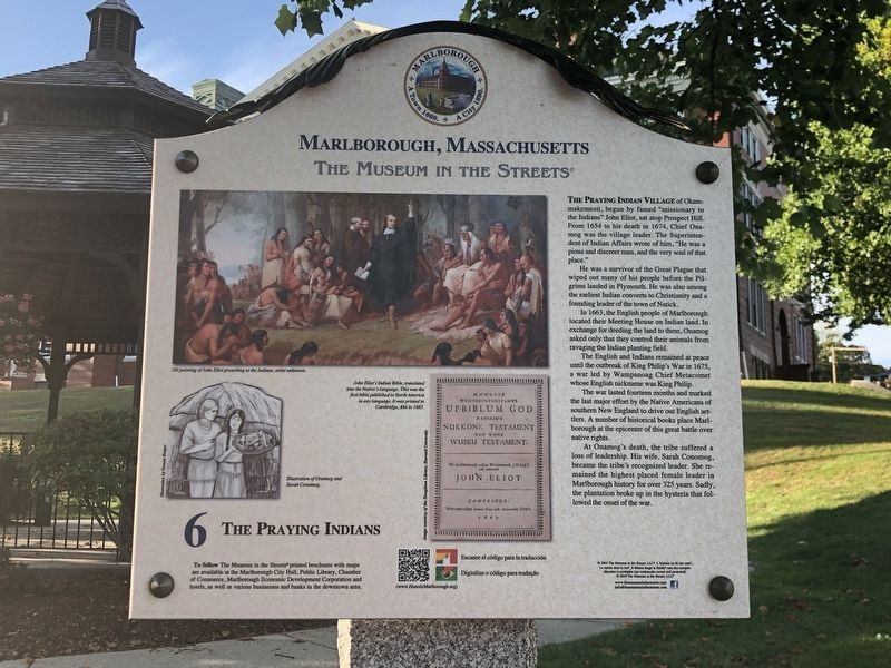
The Praying Indian village of Okammakemesit, began by famed “missionary to the Indians” John Eliot, sat atop Prospect Hill. From 1654 to his death in 1674, Chief Onamog was the village leader. The Superintendent of Indian Affairs wrote of him, “He was a pious and discreet man, and the very soul of that place.”
He was a survivor of the Great Plague that wiped out many of his people before the Pilgrims landed in Plymouth. He was also among the earliest Indian converts to Christianity and a founding leader of the town of Natick.
In 1663, the English people of Marlborough located their Meeting House on Indian land. In exchange for deeding the land to them, Onamog asked only that they control their animals from ravaging the Indian planting field.
The English and Indians remained at peace until the outbreak of King Philip's War in 1675, a war led by Wampanoag Chief Metacomet whose English nickname was King Philip.
The war lasted fourteen months and marked the last major effort by the Native Americans of southern New England to drive out English settlers. A number of historical books place Marlborough
this page online
At Onamog's death, the tribe suffered a loss of leadership. His wife, Sarah Conomog, became the tribe's recognized leader. She remained the highest placed female leader in Marlborough history for over 325 years. Sadly, the plantation broke up in the hysteria that followed the onset of the war.
[Captions:]
Oil painting of John Eliot preaching to the Indians, artist unknown.
Illustration of Onamog and Sarah Conomog.
John Eliot's Indian Bible, translated into the Natives' language. This was the first bible published in North America in any language. It was printed in Cambridge, MA in 1663.
Erected by The Museum in the Streets. (Marker Number 6.)
Topics and series. This historical marker is listed in these topic lists: Indigenous Peoples and Communities • Religion & Religious Structures • Wars, US Indian. In addition, it is included in the King Philip's War 1675-1676 series list. A significant historical year for this entry is 1654.
Location. 42° 20.806′ N, 71° 33.103′ W. Marker is in Marlborough, Massachusetts, in Middlesex County. It is at the intersection
Photographed by Duane and Tracy Marsteller, September 30, 2024
2. The Praying Indians Marker

Regionally, this marker is in Greater Boston. It is also in the American Northeast, in New England, and on the Eastern Seaboard. Globally, it is in the North Atlantic Region, North America, the Western Hemisphere, the Western World, and the Anglosphere. Historically, it finds itself in what was once one of the original Thirteen Colonies.
Other nearby markers. At least 8 other markers are within walking distance of this marker: Doughboy Monument (a few steps from this marker); A Noble Train of Artillery (within shouting distance of this marker); Gen. Henry Knox Trail (within shouting distance of this marker); The Parade of Colonial History (within shouting distance of this marker); Artemas Ward Park (within shouting distance of this marker); High School Common (within shouting distance of this marker); The First Meeting House & The Old Common (within shouting distance of this marker); When the Locals Beat the Pros (about 300 feet away, measured in a direct line). Touch for a list and map of all markers in Marlborough.
Related markers. Click here for a list of markers that are related to this marker.
Also see . . .
1. City of Marlborough - Museum in the Streets - English. Collection of links to more information about the subjects of each panel, including this one. (Marlborough Historical Society) (Submitted on November 9, 2024, by Duane and Tracy Marsteller of Murfreesboro, Tennessee.)
2. Eliot Indian Bible. Wikipedia entry on the book, also known as the Algonquian Bible. (Submitted on November 9, 2024, by Duane and Tracy Marsteller of Murfreesboro, Tennessee.)
3. Praying town - Wikipedia.
Praying towns were settlements established by English colonial governments in New England from 1646 to 1675 in an effort to convert local Native Americans to Christianity. The Native people who moved into the towns were known as Praying Indians.(Submitted on March 23, 2026, by G.W.Bartlett of Hingham, Massachusetts.)
Credits. This page was last revised on April 17, 2026. It was originally submitted on November 7, 2024, by Duane and Tracy Marsteller of Murfreesboro, Tennessee. This page has been viewed 457 times since then and 69 times this year. Last updated on March 23, 2026, by G.W.Bartlett of Hingham, Massachusetts. Photos: 1, 2. submitted on November 7, 2024, by Duane and Tracy Marsteller of Murfreesboro, Tennessee. • Devry Becker Jones was the editor who published this page.
