Near Conway in Webster County, Missouri — The American Midwest (Upper Plains)
Wardens Station
Wardens Station and Camp Gravely
Photographed by Gregory William Wadley
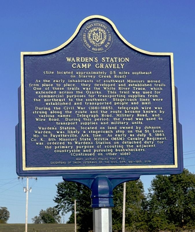
1. Wardens Station Marker
As the early inhabitants of southwest Missouri moved from place to place. They developed and established trails. One of these trails was the White River Trace, which extended across the Ozarks. This trail was used for commercial purposes for transporting supplies from the northeast to the southwest. Stagecoach lines were established and transported people and mail. During the Civil War (1861-1865) telegraph wire was strung along the route and the route became known by various names. Telegraph Road. Military Road. and Wire Road. During this time period the road was used to transport supplies and military units. Wardens Station located on land owned by Johnson Warden was likely a stagecoach stop on the St Louis Mo. to Fayetteville Ark. line. As early as July, 5, 1863 Co. K 8th Missouri State Militia (MSM) Cavalry Regiment was ordered to Wardens station on detached duty for the primary purpose of scouting the adjacent countryside and pursuing bushwhackers.
Erected 2019.
Topics. This historical marker is listed in these topic lists: Roads & Vehicles • Settlements & Settlers • War, US Civil. A significant historical date for this entry is July 5, 1863.
Location. 37° 29.046′ N,
this page online

Regionally, this marker is in Southwest Missouri and in Greater Springfield. It is also in the American Ozarks, in the Lewis & Clark Corridor, and in the Corn Belt. Globally, it is in North America, the Western Hemisphere, the Western World, and the Anglosphere. Historically, it finds itself in what was once the territory of the Mississippian Culture, the Louisiana Purchase, and the Antebellum South.
Other nearby markers. At least 8 other markers are within 11 miles of this marker, measured as the crow flies: Carter & Lawson's - Underpass Cafe and Service Station (approx. 7.8 miles away); Trail of Tears (approx. 10 miles away); Webster County (approx. 10.1 miles away); In Remembrance of Those Who Helped Shape Our Community (approx. 10.1 miles away); Edwin Hubble (approx. 10.1 miles away); Marshfield Hand Dug Well (approx.
Photographed by Gregory William Wadley, March 22, 2026
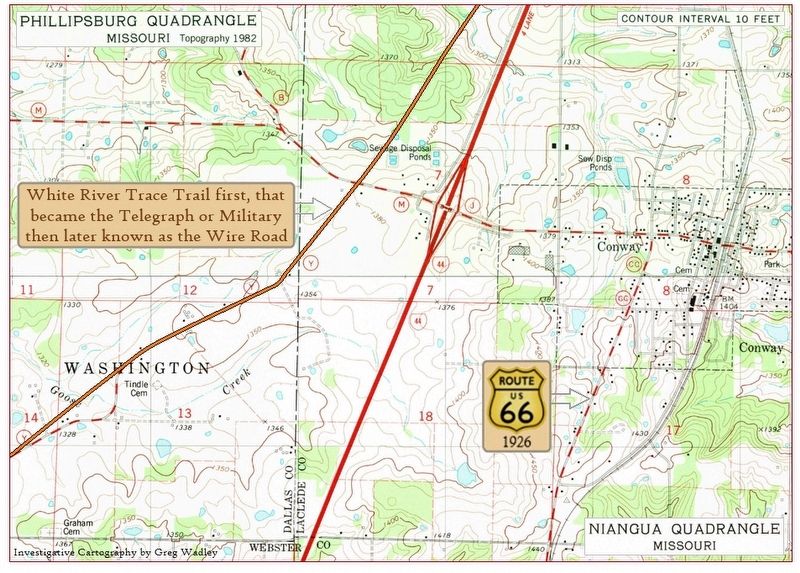
2. Next map north of Wardens Station Marker
Now entering Dallas and Laclede Co. at Conway Missouri getting close to Route 66 showing the historic Road on a modern Topographical Map.
Photographed by Gregory William Wadley, March 22, 2026
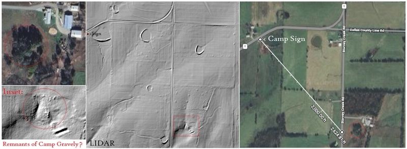
3. Wardens Station Marker
Sign states Camp Gravely was 0.5mi to the southeast. Shown here is the probable location based on distance and LIDAR scan of the area.

courtesy U.S. Geological Survey, U.S. Department of the Interior, 1946
4. White River Trace Trail also know as the Old Wire Road
Road began as a Indian Trail then improved by the Spanish and Pioneers becoming the main Road from Saint Louis Mo. to Fayetteville Ark.
Credits. This page was last revised on March 23, 2026. It was originally submitted on March 22, 2026, by Gregory William Wadley of Fremont Hills, Missouri. This page has been viewed 26 times since then. Last updated on March 23, 2026, by Gregory William Wadley of Fremont Hills, Missouri. Photos: 1, 2, 3, 4. submitted on March 22, 2026, by Gregory William Wadley of Fremont Hills, Missouri. • Devry Becker Jones was the editor who published this page.
Editor’s want-list for this marker. wide shot of the marker in context • Can you help?
