Menomonee Falls in Waukesha County, Wisconsin — The American Midwest (Great Lakes)
Fussville
Photographed by Greta Schassler, May 31, 2025
1. Fussville Marker
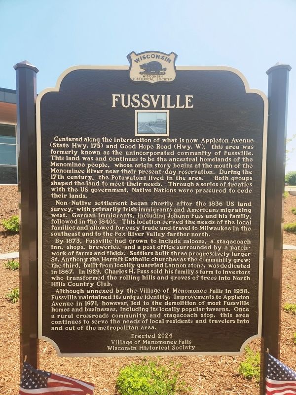
Centered along the intersection of what is now Appleton Avenue (State Hwy. 175) and Good Hope Road (Hwy. W), this area was formerly known as the unincorporated community of Fussville. This land was and continues to be the ancestral homelands of the Menominee people, whose origin story begins at the mouth of the Menominee River near their present-day reservation. During the 17th century, the Potawatomi lived in the area. Both groups shaped the land to meet their needs. Through a series of treaties with the US government, Native Nations were pressured to cede their lands.
Non-Native settlement began shortly after the 1836 US land survey, with primarily Irish immigrants and Americans migrating west. German immigrants, including Johann Fuss and his family, followed in the 1840s. This location served the needs of the local families and allowed for easy trade and travel to Milwaukee in the southeast and to the Fox River Valley farther north.
By 1873, Fussville had grown to include saloons, a stagecoach inn, shops, breweries, and a post office surrounded by a patchwork of farm and fields. Settlers built three progressively
this page online
Although annexed by the village of Menomonee Falls in 1958, Fussville maintained its unique identity. Improvements to Appleton Avenue in 1971, however, led to the demolition of most Fussville homes and businesses, including its locally popular taverns. Once a rural crossroads community and stagecoach stop, this area continues to serve the needs of local residents and travelers into and out of the metropolitan area.
Erected 2025 by Villiage of Menomonee Falls, Wisconsin Historical Society. (Marker Number 621.)
Topics. This historical marker is listed in these topic lists: Indigenous Peoples and Communities • Religion & Religious Structures • Roads & Vehicles • Settlements & Settlers. A significant historical year for this entry is 1836.
Location. 43° 8.876′ N, 88° 4.389′ W. Marker is in Menomonee Falls, Wisconsin, in Waukesha
Photographed by Paul Fehrenbach, June 2, 2025
2. Fussville Marker
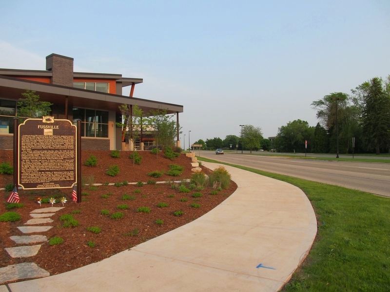
Looking southeast along Appleton Avenue

Regionally, this marker is in Southeast Wisconsin and in Greater Milwaukee. It is also in the American Midwest and in the Corn Belt. Globally, it is in North America, the Western Hemisphere, the Western World, and the Anglosphere. Historically, it finds itself in what was once the Viceroyalty of New France, the territory of the Mississippian Culture, and the Northwest Territory.
Other nearby markers. At least 8 other markers are within 4 miles of this marker, measured as the crow flies: Birthplace of the Wisconsin Evangelical Lutheran Synod (approx. 1½ miles away); Menomonee River and Lower Falls (approx. 2.8 miles away); Frederick Nehs Mill and Mill Dam (approx. 3 miles away); Mill Pond Park (approx. 3.1 miles away); Third Street Bridge (approx. 3.1 miles away); Steichen House (approx. 3.4 miles away); Sunnyside School Bell Tower Replica (approx. 3.4

Photographed by Paul Fehrenbach, June 2, 2025
3. Fussville Marker
Looking east along Good Hope Road
Another marker is no longer nearby. George L. Clarke House (was approx. 3 miles away but has been confirmed missing).
Credits. This page was last revised on March 30, 2026. It was originally submitted on May 31, 2025, by Greta Mulder of Milwaukee, Wisconsin. This page has been viewed 785 times since then and 227 times this year. Last updated on March 28, 2026, by Devon Polzar of Port Washington, Wisconsin. Photos: 1. submitted on May 31, 2025, by Greta Mulder of Milwaukee, Wisconsin. 2, 3. submitted on June 3, 2025, by Paul Fehrenbach of Richfield, Wisconsin. • Devry Becker Jones was the editor who published this page.
